
FCCInfo.com
A Service of Cavell, Mertz & Associates, Inc.
(855) FCC-INFO
|
|
KDOR-TV from 01/03/1983 |
Post-repack Channel 36 Virtual Channel 17 |  |
|
|||||||||||||||
|
|
Repacking Information: Pre-Repack Channel: 17 Post-Repack Channel: 36 Post-Repack ERP: 1000 kW Phase: 2 Completion Deadline: 4/12/2019 Upstream/Downstream Dependencies Other Linked Stations Find nearby TV Facilities Status: License Application Accepted: 02/11/2019 License Expires: 06/01/2022 File Number: -0000067842 FCC Website Links: LMS Facility Details This Application Other KDOR-TV Applications Including Superseded Applications Mailing Address Correspondence for KDOR-TV Correspondence related to application -0000067842 Service Contour - Open Street Map or USGS Map (41 dBu) Service Contour - KML / Google Earth (41 dBu) Public Inspection Files Rabbit Ears Info Search for KDOR-TV Site Location: 36-30-56.6 N 95-46-15.3 W (NAD 83) Site Location: 36-30-56.3 N 95-46-14.4 W (Converted to NAD 27) ERP: 1000 kW Polarization: Horizontally polarized HAAT: 315.4 m (1035 ft.) Electrical Beam Tilt: 1 degree R/C AGL: 322 m (1056 ft.) R/C AMSL: 520.5 m (1708 ft.) Site Elevation: 198.5 m. (651 ft.) Height Overall*: 326.5 m (1071 ft.) (* As Filed In This Application, may differ from ASR Data, Below.) Directional Antenna - Antenna Make/Model: Electronics Research Inc. ATW22H4-HTC1-36H Antenna ID: 1004629 Polarization: Horizontally polarized | ||||||||||||||||||
| Antenna Data for Antenna Id: 1004629 KDOR-TV DT File: -0000067842 Electronics Research Inc. - ATW22H4-HTC1-36H Service: DT Standard Pattern: N | 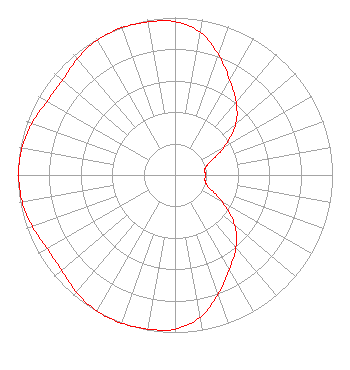 | ||||||||||||||||||
| Azimuth | Ratio | Azimuth | Ratio | Azimuth | Ratio | Azimuth | Ratio | ||||||||||||
| 0 | 0.974 | 10 | 0.921 | 20 | 0.811 | 30 | 0.695 | ||||||||||||
| 40 | 0.604 | 50 | 0.504 | 60 | 0.363 | 70 | 0.235 | ||||||||||||
| 80 | 0.190 | 90 | 0.195 | 100 | 0.193 | 110 | 0.228 | ||||||||||||
| 120 | 0.348 | 130 | 0.495 | 140 | 0.602 | 150 | 0.691 | ||||||||||||
| 160 | 0.803 | 170 | 0.917 | 180 | 0.979 | 190 | 0.993 | ||||||||||||
| 200 | 1.000 | 210 | 0.996 | 220 | 0.972 | 230 | 0.941 | ||||||||||||
| 240 | 0.937 | 250 | 0.963 | 260 | 0.985 | 270 | 0.992 | ||||||||||||
| 280 | 0.987 | 290 | 0.966 | 300 | 0.938 | 310 | 0.935 | ||||||||||||
| 320 | 0.963 | 330 | 0.989 | 340 | 0.994 | 350 | 0.987 | ||||||||||||
Structure Registration Number 1201051 Structure Type: GTOWER Registered To: TRINITY CHRISTIAN CENTER OF SANTA ANA DBA = TRINITY BROADCASTING NETWORK INC Structure Address: 6.8 Km. Wsw Talala, OK County Name: Rogers County ASR Issued: 03/11/2014 Date Built: 10/01/2014 Site Elevation: 198.5 m (651 ft.) Structure Height: 310 m (1017 ft.) Height Overall: 326.5 m (1071 ft.) Overall Height AMSL: 525 m (1722 ft.) FAA Determination: 03/07/2014 FAA Study #: 2013-ASW-7625-OE FAA Circular #: 70/7460-1K Paint & Light FAA Chapters: 4, 7, 12 PRIOR STUDY 1984-ASW-2736-OE 36-30-56.6 N 95-46-15.3 W (NAD 83) 36-30-56.3 N 95-46-14.4 W (Converted to NAD 27) |
13600 Heritage Parkway Suite 200 Fort Worth, TX 76177 Phone: 855-826-2255 Not-for-Profit | Title: Assistant Secretary Date: 02/11/2019 Application Certifier TRINITY BROADCASTING NETWORK Trinity Christian Center Of Santa Ana, Inc. P.o. Box C-11949 Santa Ana, CA 92711 Phone: 000-000-0000 Applicant Kevin T Fisher Smith & Fisher 4791 Wintergreen Court Woodbridge, VA 22192 Consultant Colby M. May, Esq. Colby M. May, Esq., P.c. P. O. Box 15473 Washington, DC 20003 Attorney | |||||||||||||||||