
FCCInfo.com
A Service of Cavell, Mertz & Associates, Inc.
(855) FCC-INFO
|
|
KUEN from 07/10/1986 KUEN from 06/08/1984 KUEN from 05/16/1984 |
Virtual Channel 9 |
|
|||||||||||||||||||||||||||||||||||||||||||||||||||||||||||||||||||||||||||||||||||||||||||||||||||||||||||||||||||||||||||||||||||||||||||||||||||||||||||||||||||||||||||||||||||||||||||||||||||||||||||||||||||||||||||||||||||||
|
|
Repacking Information: No changes Status: License Application Accepted: 02/12/2019 License Expires: 10/01/2022 File Number: -0000067867 FCC Website Links: LMS Facility Details This Application Other KUEN Applications Including Superseded Applications Mailing Address Correspondence for KUEN Correspondence related to application -0000067867 Service Contour - Open Street Map or USGS Map (41 dBu) Service Contour - KML / Google Earth (41 dBu) Public Inspection Files Rabbit Ears Info Search for KUEN Site Location: 40-39-33.0 N 112-12-10.0 W (NAD 83) Site Location: 40-39-33.2 N 112-12-07.2 W (Converted to NAD 27) ERP: 200 kW Polarization: Horizontally polarized HAAT: 1247 m (4091 ft.) Electrical Beam Tilt: 1.7 degrees R/C AGL: 77.2 m (253 ft.) R/C AMSL: 2831.2 m (9289 ft.) Site Elevation: 2754 m. (9035 ft.) Height Overall*: 94 m (308 ft.) (* As Filed In This Application, may differ from ASR Data, Below.) Directional Antenna - Antenna Make/Model: KATHREIN 759 25063 Antenna ID: 1004634 Polarization: Horizontally polarized
| |||||||||||||||||||||||||||||||||||||||||||||||||||||||||||||||||||||||||||||||||||||||||||||||||||||||||||||||||||||||||||||||||||||||||||||||||||||||||||||||||||||||||||||||||||||||||||||||||||||||||||||||||||||||||||||||||||||||
| Antenna Data for Antenna Id: 1004634 KUEN DT File: -0000067867 KATHREIN - 759 25063 Service: DT Standard Pattern: N | 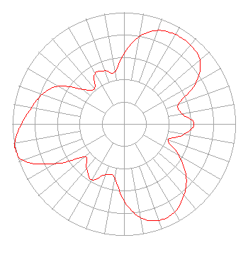 | |||||||||||||||||||||||||||||||||||||||||||||||||||||||||||||||||||||||||||||||||||||||||||||||||||||||||||||||||||||||||||||||||||||||||||||||||||||||||||||||||||||||||||||||||||||||||||||||||||||||||||||||||||||||||||||||||||||||
| Azimuth | Ratio | Azimuth | Ratio | Azimuth | Ratio | Azimuth | Ratio | |||||||||||||||||||||||||||||||||||||||||||||||||||||||||||||||||||||||||||||||||||||||||||||||||||||||||||||||||||||||||||||||||||||||||||||||||||||||||||||||||||||||||||||||||||||||||||||||||||||||||||||||||||||||||||||||||
| 0 | 0.631 | 10 | 0.797 | 20 | 0.892 | 30 | 0.925 | |||||||||||||||||||||||||||||||||||||||||||||||||||||||||||||||||||||||||||||||||||||||||||||||||||||||||||||||||||||||||||||||||||||||||||||||||||||||||||||||||||||||||||||||||||||||||||||||||||||||||||||||||||||||||||||||||
| 40 | 0.925 | 50 | 0.889 | 60 | 0.747 | 70 | 0.522 | |||||||||||||||||||||||||||||||||||||||||||||||||||||||||||||||||||||||||||||||||||||||||||||||||||||||||||||||||||||||||||||||||||||||||||||||||||||||||||||||||||||||||||||||||||||||||||||||||||||||||||||||||||||||||||||||||
| 80 | 0.528 | 90 | 0.628 | 100 | 0.545 | 110 | 0.419 | |||||||||||||||||||||||||||||||||||||||||||||||||||||||||||||||||||||||||||||||||||||||||||||||||||||||||||||||||||||||||||||||||||||||||||||||||||||||||||||||||||||||||||||||||||||||||||||||||||||||||||||||||||||||||||||||||
| 120 | 0.568 | 130 | 0.727 | 140 | 0.835 | 150 | 0.912 | |||||||||||||||||||||||||||||||||||||||||||||||||||||||||||||||||||||||||||||||||||||||||||||||||||||||||||||||||||||||||||||||||||||||||||||||||||||||||||||||||||||||||||||||||||||||||||||||||||||||||||||||||||||||||||||||||
| 160 | 0.920 | 170 | 0.853 | 180 | 0.690 | 190 | 0.488 | |||||||||||||||||||||||||||||||||||||||||||||||||||||||||||||||||||||||||||||||||||||||||||||||||||||||||||||||||||||||||||||||||||||||||||||||||||||||||||||||||||||||||||||||||||||||||||||||||||||||||||||||||||||||||||||||||
| 200 | 0.485 | 210 | 0.578 | 220 | 0.520 | 230 | 0.460 | |||||||||||||||||||||||||||||||||||||||||||||||||||||||||||||||||||||||||||||||||||||||||||||||||||||||||||||||||||||||||||||||||||||||||||||||||||||||||||||||||||||||||||||||||||||||||||||||||||||||||||||||||||||||||||||||||
| 240 | 0.715 | 250 | 0.959 | 257 | 1.000 | 260 | 0.993 | |||||||||||||||||||||||||||||||||||||||||||||||||||||||||||||||||||||||||||||||||||||||||||||||||||||||||||||||||||||||||||||||||||||||||||||||||||||||||||||||||||||||||||||||||||||||||||||||||||||||||||||||||||||||||||||||||
| 270 | 0.919 | 280 | 0.841 | 290 | 0.778 | 300 | 0.677 | |||||||||||||||||||||||||||||||||||||||||||||||||||||||||||||||||||||||||||||||||||||||||||||||||||||||||||||||||||||||||||||||||||||||||||||||||||||||||||||||||||||||||||||||||||||||||||||||||||||||||||||||||||||||||||||||||
| 310 | 0.481 | 320 | 0.411 | 330 | 0.520 | 340 | 0.507 | |||||||||||||||||||||||||||||||||||||||||||||||||||||||||||||||||||||||||||||||||||||||||||||||||||||||||||||||||||||||||||||||||||||||||||||||||||||||||||||||||||||||||||||||||||||||||||||||||||||||||||||||||||||||||||||||||
| 350 | 0.471 | |||||||||||||||||||||||||||||||||||||||||||||||||||||||||||||||||||||||||||||||||||||||||||||||||||||||||||||||||||||||||||||||||||||||||||||||||||||||||||||||||||||||||||||||||||||||||||||||||||||||||||||||||||||||||||||||||||||||
Structure Registration Number 1062408 Structure Type: TOWER Registered To: DTV Utah, LC Structure Address: Farnsworth Peak, 10 Kilometers Sw Of Magna Salt Lake City, UT County Name: Salt Lake County ASR Issued: 11/05/2020 Date Built: 10/28/1999 Site Elevation: 2754 m (9035 ft.) Structure Height: 94 m (308 ft.) Height Overall: 94 m (308 ft.) Overall Height AMSL: 2848 m (9344 ft.) FAA Determination: 03/11/1999 FAA Study #: 99-ANM-0178-OE FAA Circular #: 70/7460-1J Paint & Light FAA Chapters: 4, 8, 13 Removed expiration date from determination. Scenario 1./jjs/case#635066 40-39-33.0 N 112-12-10.0 W (NAD 83) 40-39-33.2 N 112-12-07.2 W (Converted to NAD 27) |
101 S. Wasatch Drive Room 215 Salt Lake City, UT 84112 Phone: 501-585-1601 Government Entity | Title: Director Of Engineering Kued/kuen Date: 02/12/2019 Application Certifier UTAH STATE BOARD OF REGENTS Utah State Board Of Regents 101 S. Wasatch Drive Room 215 Salt Lake City, UT 84112 Applicant Ann West Bobeck, Esq Covington & Burling Llp One Citycenter 850 Tenth Street Nw Washington, DC 20001 William Meintel Meintel, Sgrignoli & Wallace, Llc Warrenton, VA 20187 Senior Partner Philip Titus Kuew / Utah State Board Of Regents 101 S. Wasatch Drive Salt Lake City, UT 84112 DIRECTOR OF ENGINEERING | ||||||||||||||||||||||||||||||||||||||||||||||||||||||||||||||||||||||||||||||||||||||||||||||||||||||||||||||||||||||||||||||||||||||||||||||||||||||||||||||||||||||||||||||||||||||||||||||||||||||||||||||||||||||||||||||||||||||
| ||||||||||||||||||||||||||||||||||||||||||||||||||||||||||||||||||||||||||||||||||||||||||||||||||||||||||||||||||||||||||||||||||||||||||||||||||||||||||||||||||||||||||||||||||||||||||||||||||||||||||||||||||||||||||||||||||||||||