
FCCInfo.com
A Service of Cavell, Mertz & Associates, Inc.
(855) FCC-INFO
|
|
WLWC from 05/15/1991 WLWC from 03/25/1987 WLWC from 12/22/1982 |
RF spectrum relinquished in the spectrum auction Virtual Channel 28 |  |
|
|||||||||||||||
|
|
WLWC is a channel sharing guest of WPXQ-TV, Newport, Rhode Island Repacking Information: Channel 22 was relinquished in the spectrum auction Status: License Application Accepted: 02/28/2019 License Expires: 04/01/2023 File Number: -0000068160 FCC Website Links: LMS Facility Details This Application Other WLWC Applications Including Superseded Applications Mailing Address Correspondence for WLWC Correspondence related to application -0000068160 Service Contour - Open Street Map or USGS Map (41 dBu) Service Contour - KML / Google Earth (41 dBu) Public Inspection Files Rabbit Ears Info Search for WLWC Site Location: 41-29-41.7 N 71-47-04.7 W (NAD 83) Site Location: 41-29-41.3 N 71-47-06.5 W (Converted to NAD 27) ERP: 1000 kW Polarization: Horizontally polarized HAAT: 228 m (748 ft.) Electrical Beam Tilt: 0.6 degrees R/C AGL: 179.5 m (589 ft.) R/C AMSL: 298 m (978 ft.) Site Elevation: 118.5 m. (389 ft.) Height Overall*: 201.1 m (660 ft.) (* As Filed In This Application, may differ from ASR Data, Below.) Directional Antenna - Antenna Make/Model: DIELECTRIC TFU-15JTH-R CT170 SP Antenna ID: 67093 Polarization: Horizontally polarized | ||||||||||||||||||
| Antenna Data for Antenna Id: 67093 WLWC DT File: -0000068160 DIELECTRIC - TFU-15JTH-R CT170 SP Service: DT Standard Pattern: Y | 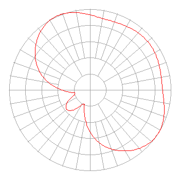 | ||||||||||||||||||
| Azimuth | Ratio | Azimuth | Ratio | Azimuth | Ratio | Azimuth | Ratio | ||||||||||||
| 0 | 0.927 | 10 | 0.896 | 20 | 0.893 | 30 | 0.907 | ||||||||||||
| 40 | 0.923 | 50 | 0.929 | 60 | 0.923 | 70 | 0.907 | ||||||||||||
| 80 | 0.893 | 90 | 0.896 | 100 | 0.927 | 110 | 0.970 | ||||||||||||
| 120 | 0.998 | 123 | 1.000 | 130 | 0.991 | 140 | 0.945 | ||||||||||||
| 150 | 0.872 | 160 | 0.780 | 170 | 0.665 | 180 | 0.522 | ||||||||||||
| 190 | 0.354 | 200 | 0.210 | 204 | 0.191 | 210 | 0.224 | ||||||||||||
| 220 | 0.329 | 230 | 0.376 | 240 | 0.329 | 250 | 0.224 | ||||||||||||
| 256 | 0.191 | 260 | 0.210 | 270 | 0.354 | 280 | 0.522 | ||||||||||||
| 290 | 0.665 | 300 | 0.780 | 310 | 0.872 | 320 | 0.945 | ||||||||||||
| 330 | 0.991 | 337 | 1.000 | 340 | 0.998 | 350 | 0.970 | ||||||||||||
Structure Registration Number 1022425 Structure Type: GTOWER Registered To: Industrial Tower and Wireless, LLC Structure Address: 245 North Road (champlin Hill) Hopkinton, RI County Name: Washington County ASR Issued: 09/14/2017 Date Built: 12/28/2004 Site Elevation: 118.5 m (389 ft.) Structure Height: 182.2 m (598 ft.) Height Overall: 201.1 m (660 ft.) Overall Height AMSL: 319.6 m (1049 ft.) FAA Determination: 03/27/2017 FAA Study #: 2017-ANE-1070-OE FAA Circular #: 70/7460-1L Paint & Light FAA Chapters: 3, 4, 5, 12 PRIOR STUDY 2003-ANE-538-OE 41-29-41.7 N 71-47-04.7 W (NAD 83) 41-29-41.3 N 71-47-06.5 W (Converted to NAD 27) |
3110 W California Avenue, Suite C Salt Lake City, UT 84098 Phone: 435-414-1338 Limited Liability Company | Application Certifier OTA BROADCASTING (PVD), LLC Ota Broadcasting (pvd), Llc 11710 Plaza America Drive Suite 2000 Reston, VA 20190 Applicant David Sanderford Marsand, Inc. 1957 Reynolds Dr Azle, TX 76020 | |||||||||||||||||