
FCCInfo.com
A Service of Cavell, Mertz & Associates, Inc.
(855) FCC-INFO
|
|
KSKT-CD from 08/20/2001 KSKT-CD from 12/04/1990 |
Virtual Channel 43 |
|
||||||||||||||||
|
|
Repacking Information: No changes Status: License Application Accepted: 04/01/2019 License Expires: 12/01/2022 File Number: -0000068950 FCC Website Links: LMS Facility Details This Application Other KSKT-CD Applications Including Superseded Applications Mailing Address Correspondence for KSKT-CD Correspondence related to application -0000068950 Service Contour - Open Street Map or USGS Map (51 dBu) Service Contour - KML / Google Earth (51 dBu) Public Inspection Files Rabbit Ears Info Search for KSKT-CD Site Location: 33-00-32.0 N 116-58-19.0 W (NAD 83) Site Location: 33-00-31.8 N 116-58-15.9 W (Converted to NAD 27) ERP: 15 kW Polarization: Elliptically polarized Electrical Beam Tilt: 1.5 degrees R/C AGL: 15 m (49 ft.) R/C AMSL: 895 m (2936 ft.) Emission Mask: Stringent Site Elevation: 880 m. (2887 ft.) Height Overall*: 28 m (92 ft.) (* As Filed In This Application, may differ from ASR Data, Below.) Directional Antenna - Antenna Make/Model: ATC BPE4C2-U Antenna ID: 1004790 Polarization: Elliptically polarized | ||||||||||||||||||
| Antenna Data for Antenna Id: 1004790 KSKT-CD DC File: -0000068950 ATC - BPE4C2-U Service: DC Standard Pattern: N Pattern and Field Values Include a 185° Clockwise Rotation | 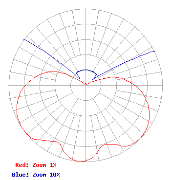 | ||||||||||||||||||
| Azimuth | Ratio | Azimuth | Ratio | Azimuth | Ratio | Azimuth | Ratio | ||||||||||||
| 5 | 0.020 | 15 | 0.020 | 25 | 0.020 | 35 | 0.020 | ||||||||||||
| 45 | 0.020 | 55 | 0.020 | 65 | 0.130 | 75 | 0.395 | ||||||||||||
| 85 | 0.560 | 95 | 0.710 | 105 | 0.825 | 115 | 0.915 | ||||||||||||
| 125 | 0.975 | 135 | 0.990 | 145 | 0.968 | 155 | 0.855 | ||||||||||||
| 165 | 0.827 | 175 | 0.955 | 185 | 1.000 | 195 | 0.945 | ||||||||||||
| 205 | 0.830 | 215 | 0.885 | 225 | 0.979 | 235 | 0.995 | ||||||||||||
| 245 | 0.975 | 255 | 0.920 | 265 | 0.835 | 275 | 0.715 | ||||||||||||
| 285 | 0.580 | 295 | 0.410 | 305 | 0.135 | 315 | 0.020 | ||||||||||||
| 325 | 0.020 | 335 | 0.020 | 345 | 0.020 | 355 | 0.020 | ||||||||||||
Structure Registration Number 1026468 Structure Type: TOWER Registered To: Palomar Communications, Inc. Structure Address: Woodson Mountain Near Poway, CA County Name: San Diego County ASR Issued: 11/30/2022 Date Built: 01/01/1980 Site Elevation: 880 m (2887 ft.) Structure Height: 28 m (92 ft.) Height Overall: 28 m (92 ft.) Overall Height AMSL: 908 m (2979 ft.) FAA Determination: 08/14/1997 FAA Study #: 97-AWP-1915-OE Paint & Light FAA Chapters: NONE Removed expiration date from determination. Scenario 1./jjs/case#635066 33-00-32.0 N 116-58-19.0 W (NAD 83) 33-00-31.8 N 116-58-15.9 W (Converted to NAD 27) |
295 Madison Avenue, 12th Floor New York, NY 10017 Phone: 954-606-5486 Corporation | Title: Chief Operating Officer Date: 04/01/2019 Application Certifier Hc2 Station Group, Inc. 450 Park Avenue 30th Floor New York, NY 10022 Applicant PAUL A. CICELSKI Lerman Senter Pllc 2001 L Street, Nw Suite 400 Washington, DC 20036 LEGAL REPRESENTATIVE KURT HANSON Hc2 Broadcasting Holdings Inc. 450 Park Avenue 30th Floor New York, NY 10022 CHIEF TECHNICAL OFFICER REBECCA HANSON Hc2 Broadcasting Holdings Inc. 450 Park Avenue 30th Floor New York, NY 10022 EVP AND GENERAL COUNSEL RENEE ILHARDT Hc2 Broadcasting Holdings Inc. 450 Park Avenue 30th Floor New York, NY 10022 CORPORATE REPRESENTATIVE | |||||||||||||||||