
FCCInfo.com
A Service of Cavell, Mertz & Associates, Inc.
(855) FCC-INFO
|
|
K20NB-D from 12/13/2010 |
|
|
||||||||||||||||
|
|
Status: License Application Accepted: 05/07/2019 License Expires: 10/03/2022 File Number: -0000072467 FCC Website Links: LMS Facility Details This Application Other K20NB-D Applications Including Superseded Applications Mailing Address Correspondence for K20NB-D Correspondence related to application -0000072467 Service Contour - Open Street Map or USGS Map (51 dBu) Service Contour - KML / Google Earth (51 dBu) Rabbit Ears Info Search for K20NB-D Site Location: 38-12-40.8 N 112-14-04.1 W (NAD 83) Site Location: 38-12-40.9 N 112-14-01.4 W (Converted to NAD 27) ERP: 0.045 kW Polarization: Horizontally polarized R/C AGL: 5.5 m (18 ft.) R/C AMSL: 1985.5 m (6514 ft.) Emission Mask: Simple Site Elevation: 1980 m. (6496 ft.) Height Overall*: 10.3 m (34 ft.) (* As Filed In This Application, may differ from ASR Data, Below.) Directional Antenna - Antenna Make/Model: Kathrein 1X2 750-10210 Antenna ID: 1004988 Polarization: Horizontally polarized
| ||||||||||||||||||
| Antenna Data for Antenna Id: 1004988 K20NB-D LD File: -0000072467 Kathrein - 1X2 750-10210 Service: LD Standard Pattern: N Pattern and Field Values Include a 120° Clockwise Rotation | 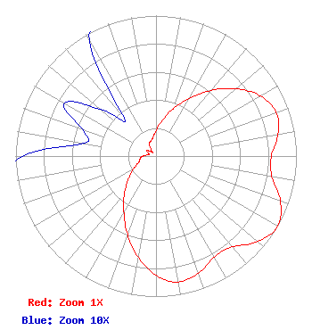 | ||||||||||||||||||
| Azimuth | Ratio | Azimuth | Ratio | Azimuth | Ratio | Azimuth | Ratio | ||||||||||||
| 0 | 0.183 | 10 | 0.258 | 20 | 0.357 | 30 | 0.473 | ||||||||||||
| 40 | 0.610 | 50 | 0.745 | 60 | 0.857 | 70 | 0.911 | ||||||||||||
| 80 | 0.882 | 90 | 0.822 | 100 | 0.838 | 110 | 0.944 | ||||||||||||
| 120 | 1.000 | 130 | 0.946 | 140 | 0.844 | 150 | 0.829 | ||||||||||||
| 160 | 0.887 | 170 | 0.910 | 180 | 0.850 | 190 | 0.731 | ||||||||||||
| 200 | 0.594 | 210 | 0.459 | 220 | 0.349 | 230 | 0.257 | ||||||||||||
| 240 | 0.187 | 250 | 0.132 | 260 | 0.116 | 270 | 0.095 | ||||||||||||
| 280 | 0.052 | 290 | 0.056 | 300 | 0.075 | 310 | 0.052 | ||||||||||||
| 320 | 0.035 | 330 | 0.095 | 340 | 0.112 | 350 | 0.131 | ||||||||||||
Structure Registration Number 1273462 Structure Type: TOWER Registered To: Piute County Structure Address: Approx. 2 Miles Sw Of Junction, Utah. Junction, UT County Name: Piute County ASR Issued: 03/10/2010 Date Built: 11/10/2008 Site Elevation: 1980 m (6496 ft.) Structure Height: 10.3 m (34 ft.) Height Overall: 10.3 m (34 ft.) Overall Height AMSL: 1990.3 m (6530 ft.) FAA Determination: 02/23/2010 FAA Study #: 2010-ANM-152-OE Paint & Light FAA Chapters: NONE PRIOR STUDY 2008-ANM-231-OE 38-12-40.8 N 112-14-04.1 W (NAD 83) 38-12-40.9 N 112-14-01.4 W (Converted to NAD 27) |
550 North Main Street Courthouse Building Junction, UT 84740 Phone: 435-577-2840 Government Entity | Title: Technical Representative Date: 05/07/2019 Application Certifier PIUTE COUNTY Piute County 550 North Main Street Courthouse Building Junction, UT 84740 Applicant Kali Gleave Piute County 550 North Main Street Courthouse Building Junction, UT 84740 Auditor/Clerk MAURI KENT PARSONS Piute County 371 South 460 East Monroe, UT 84754 Technical Representative | |||||||||||||||||