
FCCInfo.com
A Service of Cavell, Mertz & Associates, Inc.
(855) FCC-INFO
|
|
WIPL from 08/01/1997 WIPL from 10/02/1989 |
Post-repack Channel 24 Virtual Channel 35 |  |
|
|||||||||||||||
|
|
Repacking Information: Pre-Repack Channel: 35 Post-Repack Channel: 24 Post-Repack ERP: 11.4 kW Phase: 3 Completion Deadline: 6/21/2019 Find nearby TV Facilities Status: License Application Accepted: 06/28/2019 License Expires: 04/01/2023 File Number: -0000075152 FCC Website Links: LMS Facility Details This Application Other WIPL Applications Including Superseded Applications Mailing Address Correspondence for WIPL Correspondence related to application -0000075152 Service Contour - Open Street Map or USGS Map (41 dBu) Service Contour - KML / Google Earth (41 dBu) Public Inspection Files Rabbit Ears Info Search for WIPL Site Location: 43-50-44.0 N 70-45-41.0 W (NAD 83) Site Location: 43-50-43.7 N 70-45-42.8 W (Converted to NAD 27) ERP: 16 kW Polarization: Elliptically polarized HAAT: 542.25 m (1779 ft.) Electrical Beam Tilt: 1.00 degree R/C AGL: 426.8 m (1400 ft.) R/C AMSL: 695.8 m (2283 ft.) Site Elevation: 269 m. (883 ft.) Height Overall*: 508 m (1667 ft.) (* As Filed In This Application, may differ from ASR Data, Below.) Directional Antenna - Antenna Make/Model: DIELECTRIC TLP-8C/VP-R Antenna ID: 1005176 Polarization: Elliptically polarized | ||||||||||||||||||
| Antenna Data for Antenna Id: 1005176 WIPL DT File: -0000075152 DIELECTRIC - TLP-8C/VP-R Service: DT Standard Pattern: N | 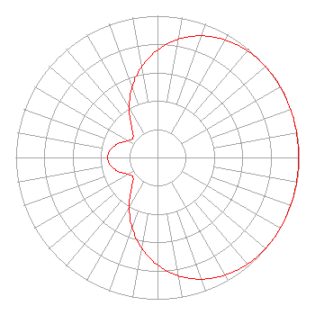 | ||||||||||||||||||
| Azimuth | Ratio | Azimuth | Ratio | Azimuth | Ratio | Azimuth | Ratio | ||||||||||||
| 0 | 0.758 | 10 | 0.847 | 20 | 0.913 | 30 | 0.958 | ||||||||||||
| 40 | 0.984 | 50 | 0.997 | 60 | 1.000 | 70 | 0.999 | ||||||||||||
| 80 | 0.996 | 90 | 0.995 | 100 | 0.996 | 110 | 0.999 | ||||||||||||
| 120 | 1.000 | 130 | 0.997 | 140 | 0.984 | 150 | 0.958 | ||||||||||||
| 160 | 0.913 | 170 | 0.847 | 180 | 0.758 | 190 | 0.650 | ||||||||||||
| 200 | 0.526 | 210 | 0.398 | 220 | 0.286 | 230 | 0.224 | ||||||||||||
| 240 | 0.238 | 250 | 0.291 | 260 | 0.335 | 270 | 0.352 | ||||||||||||
| 280 | 0.335 | 290 | 0.291 | 300 | 0.238 | 310 | 0.224 | ||||||||||||
| 320 | 0.286 | 330 | 0.398 | 340 | 0.526 | 350 | 0.650 | ||||||||||||
Structure Registration Number 1045602 Structure Type: TOWER Registered To: Hearst Properties Inc. Structure Address: Western Peak Of Bald Mountain Baldwin, ME County Name: Cumberland County ASR Issued: 08/27/2015 Date Built: 02/01/2003 Site Elevation: 269 m (883 ft.) Structure Height: 474 m (1555 ft.) Height Overall: 508 m (1667 ft.) Overall Height AMSL: 777 m (2549 ft.) FAA Determination: 03/30/1998 FAA Study #: 98-ANE-0062-OE FAA Circular #: 70/7460-1J Paint & Light FAA Chapters: 3, 4, 9, 13 Removed expiration and final dates from determination. Scenario 2./jjs/case#635066 43-50-44.0 N 70-45-41.0 W (NAD 83) 43-50-43.7 N 70-45-42.8 W (Converted to NAD 27) |
312 Walnut Street 28th Floor Cincinnati, OH 45202 Phone: 513-977-3000 Limited Liability Company | Title: Vp, Engineering Date: 06/28/2019 Application Certifier Ion Media License Company, Llc 601 Clearwater Park Road West Palm Beach, FL 33401 Applicant Shea Clark Ion Media Networks 14444 66th Street N Clearwater, FL 33764 VP, Engineering Bianca Frye Ion Media Networks, Inc. 601 Clearwater Park Road West Palm Beach, FL 33401 | |||||||||||||||||