
FCCInfo.com
A Service of Cavell, Mertz & Associates, Inc.
(855) FCC-INFO
|
|
K33OH-D from 12/08/2009 |
|
|
||||||||||||||||
|
|
Status: License Application Accepted: 07/08/2019 License Expires: 04/01/2022 File Number: -0000076200 FCC Website Links: LMS Facility Details This Application Other K33OH-D Applications Including Superseded Applications Mailing Address Correspondence for K33OH-D Correspondence related to application -0000076200 Service Contour - Open Street Map or USGS Map (51 dBu) Service Contour - KML / Google Earth (51 dBu) Rabbit Ears Info Search for K33OH-D Site Location: 48-04-04.3 N 114-02-19.3 W (NAD 83) Site Location: 48-04-04.5 N 114-02-15.9 W (Converted to NAD 27) ERP: 0.112 kW Polarization: Horizontally polarized R/C AGL: 32.4 m (106 ft.) R/C AMSL: 1163.2 m (3816 ft.) Emission Mask: Simple Site Elevation: 1130.8 m. (3710 ft.) Height Overall*: 32.9 m (108 ft.) (* As Filed In This Application, may differ from ASR Data, Below.) Directional Antenna - Antenna Make/Model: Scala 1X2KBBU ARRAY Antenna ID: 94893 Polarization: Horizontally polarized
| ||||||||||||||||||
| Antenna Data for Antenna Id: 94893 K33OH-D LD File: -0000076200 Scala - 1X2KBBU ARRAY Service: LD Standard Pattern: Y | 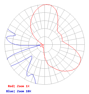 | ||||||||||||||||||
| Azimuth | Ratio | Azimuth | Ratio | Azimuth | Ratio | Azimuth | Ratio | ||||||||||||
| 0 | 0.994 | 10 | 0.986 | 20 | 0.879 | 30 | 0.668 | ||||||||||||
| 40 | 0.497 | 50 | 0.460 | 60 | 0.477 | 70 | 0.467 | ||||||||||||
| 80 | 0.460 | 90 | 0.582 | 100 | 0.770 | 110 | 0.953 | ||||||||||||
| 120 | 1.000 | 130 | 0.965 | 140 | 0.868 | 150 | 0.750 | ||||||||||||
| 160 | 0.611 | 170 | 0.499 | 180 | 0.289 | 190 | 0.123 | ||||||||||||
| 200 | 0.082 | 210 | 0.088 | 220 | 0.053 | 230 | 0.048 | ||||||||||||
| 240 | 0.115 | 250 | 0.095 | 260 | 0.011 | 270 | 0.073 | ||||||||||||
| 280 | 0.096 | 290 | 0.082 | 300 | 0.202 | 310 | 0.372 | ||||||||||||
| 320 | 0.531 | 330 | 0.680 | 340 | 0.809 | 350 | 0.921 | ||||||||||||
Structure Registration Number 1253697 Structure Type: TOWER Registered To: Swan Hill TV District Structure Address: Swan Hill Communications Site Bigfork, MT County Name: Flathead County ASR Issued: 03/09/2010 Site Elevation: 1130.8 m (3710 ft.) Structure Height: 32.9 m (108 ft.) Height Overall: 32.9 m (108 ft.) Overall Height AMSL: 1163.7 m (3818 ft.) FAA Determination: 05/08/2006 FAA Study #: 2006-ANM-771-OE Paint & Light FAA Chapters: NONE 48-04-04.3 N 114-02-19.3 W (NAD 83) 48-04-04.5 N 114-02-15.9 W (Converted to NAD 27) |
P.o. Box 530 Bigfork, MT 59911 Phone: 406-837-4132 Government Entity | Title: President Date: 07/08/2019 Application Certifier SWAN HILL TV DIST Swan Hill Tv Dist P.o. Box 530 Bigfork, MT 59911 Applicant CHARLIE CANNALIATO Canyon Tv 200 Evans Avenue Missoula, MT 59801 CONSULTING ENGINEER Susan Hansen B. W. St. Clair 2305 Vida Shaw Rd New Iberia, LA 70563 Consultant | |||||||||||||||||