FCCInfo.com
A Service of Cavell, Mertz & Associates, Inc.
(855) FCC-INFO
|
|
WDLI from 04/25/1983 WJAN-TV from 04/13/1982 WJAN from ??? |
Virtual Channel 17 |  |
|
|||||||||||||||||
|
|
WDLI-TV is a channel sharing guest of WVPX-TV, Akron, Ohio Status: LIC Application Accepted: 08/09/2019 License Expires: 10/01/2029 File Number: 0000080216 FCC Website Links: LMS Facility Details This Application Other WDLI-TV Applications Including Superseded Applications Service Contour - Open Street Map or USGS Map (41 dBu) Service Contour - KML / Google Earth (41 dBu) Public Inspection Files Rabbit Ears Info Search for WDLI-TV Site Location: 41-03-20.0 N 81-35-37.0 W (NAD 83) Site Location: 41-03-19.8 N 81-35-37.6 W (Converted to NAD 27) ERP: 950 kW Polarization: Elliptically polarized HAAT: 290.32 m (952 ft.) Electrical Beam Tilt: 0.75 degrees R/C AGL: 315.2 m (1034 ft.) R/C AMSL: 612.2 m (2009 ft.) Emission Mask: Simple Site Elevation: 297 m. (974 ft.) Height Overall*: 326 m (1070 ft.) (* As Filed In This Application, may differ from ASR Data, Below.) Directional Antenna - Antenna Make/Model: Electronics Research Inc. ATW29H3-ESC170-22H Antenna ID: 1005374 Polarization: Elliptically polarized | ||||||||||||||||||||
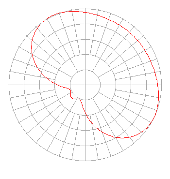
| Antenna Data for Antenna Id: 1005374 WDLI-TV DT File: -0000080216 Electronics Research Inc. - ATW29H3-ESC170-22H Service: DT Standard Pattern: N |  | ||||||||||||||||||||
| Azimuth | Ratio | Azimuth | Ratio | Azimuth | Ratio | Azimuth | Ratio | ||||||||||||||
| 0 | 0.949 | 10 | 0.926 | 20 | 0.910 | 30 | 0.902 | ||||||||||||||
| 40 | 0.900 | 50 | 0.900 | 60 | 0.902 | 70 | 0.910 | ||||||||||||||
| 80 | 0.926 | 90 | 0.949 | 100 | 0.976 | 110 | 0.996 | ||||||||||||||
| 114 | 1.000 | 120 | 0.997 | 130 | 0.968 | 140 | 0.901 | ||||||||||||||
| 150 | 0.797 | 160 | 0.663 | 170 | 0.512 | 180 | 0.365 | ||||||||||||||
| 190 | 0.251 | 200 | 0.204 | 210 | 0.219 | 220 | 0.241 | ||||||||||||||
| 230 | 0.241 | 240 | 0.219 | 250 | 0.204 | 260 | 0.251 | ||||||||||||||
| 270 | 0.365 | 280 | 0.512 | 290 | 0.663 | 300 | 0.797 | ||||||||||||||
| 310 | 0.901 | 320 | 0.968 | 330 | 0.997 | 334 | 1.000 | ||||||||||||||
| 340 | 0.996 | 350 | 0.976 | ||||||||||||||||||
Structure Registration Number 1063363 [ASR Heights Differ from WDLI-TV Application] Structure Type: GTOWER Registered To: ION Station Properties, LLC Structure Address: Sr 261, 1.1 Km. West Of Romig Rd. Norton, OH County Name: Summit County ASR Issued: 07/12/2024 Date Built: 06/17/2024 Site Elevation: 296 m (971 ft.) Structure Height: 326.1 m (1070 ft.) Height Overall: 326.1 m (1070 ft.) Overall Height AMSL: 622.1 m (2041 ft.) FAA Determination: 06/24/2024 FAA Study #: 2024-AGL-8869-OE FAA Circular #: 70/7460-1M Paint & Light FAA Chapters: 3, 4, 5, 15 PRIOR STUDY 2019-AGL-14612-OE 41-03-20.5 N 81-35-37.0 W (NAD 83) 41-03-20.3 N 81-35-37.6 W (Converted to NAD 27) |
2037 South 4130 West Suite D-E Salt Lake City, UT 84104 Phone: 435-414-1338 Limited Liability Company | Application Certifier Trinity Broadcasting Network Trinity Christian Center of Santa Ana, Inc. P.O. Box C11949 Santa Ana, CA 92711 Applicant Colby M May, Esq. Colby M. May, Esq., P.C. P. O. Box 15473 Washington, DC 20003 Attorney | |||||||||||||||||||