
FCCInfo.com
A Service of Cavell, Mertz & Associates, Inc.
(855) FCC-INFO
|
|
|
Post-repack Channel 17 Virtual Channel 46 |  |
|
|||||||||||||||||||||
|
|
Repacking Information: Pre-Repack Channel: 46 Post-Repack Channel: 17 Post-Repack ERP: 272 kW Phase: 6 Completion Deadline: 10/18/2019 Find nearby TV Facilities Status: License Application Accepted: 10/17/2019 License Expires: 08/01/2022 File Number: -0000086804 FCC Website Links: LMS Facility Details This Application Other KNCT Applications Including Superseded Applications Mailing Address Correspondence for KNCT Correspondence related to application -0000086804 Service Contour - Open Street Map or USGS Map (41 dBu) Service Contour - KML / Google Earth (41 dBu) Public Inspection Files History Cards for KNCT Rabbit Ears Info Search for KNCT Site Location: 31-19-19.2 N 97-19-03.0 W (NAD 83) Site Location: 31-19-18.6 N 97-19-02.0 W (Converted to NAD 27) ERP: 1000 kW Polarization: Elliptically polarized HAAT: 505.7 m (1659 ft.) Electrical Beam Tilt: 0.75 degrees R/C AGL: 451.1 m (1480 ft.) R/C AMSL: 711.1 m (2333 ft.) Site Elevation: 260 m. (853 ft.) Height Overall*: 508.1 m (1667 ft.) (* As Filed In This Application, may differ from ASR Data, Below.) Directional Antenna - Antenna Make/Model: DIELECTRIC TFU-28DSC/VP-R C170 Antenna ID: 1005782 Polarization: Elliptically polarized | ||||||||||||||||||||||||
| Antenna Data for Antenna Id: 1005782 KNCT DT File: -0000086804 DIELECTRIC - TFU-28DSC/VP-R C170 Service: DT Standard Pattern: N | 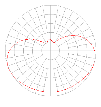 | ||||||||||||||||||||||||
| Azimuth | Ratio | Azimuth | Ratio | Azimuth | Ratio | Azimuth | Ratio | ||||||||||||||||||
| 0 | 0.238 | 10 | 0.209 | 20 | 0.184 | 30 | 0.226 | ||||||||||||||||||
| 40 | 0.346 | 50 | 0.499 | 60 | 0.655 | 70 | 0.794 | ||||||||||||||||||
| 80 | 0.900 | 90 | 0.968 | 100 | 0.997 | 104 | 1.000 | ||||||||||||||||||
| 110 | 0.996 | 120 | 0.977 | 130 | 0.952 | 140 | 0.931 | ||||||||||||||||||
| 150 | 0.920 | 160 | 0.915 | 170 | 0.914 | 180 | 0.914 | ||||||||||||||||||
| 190 | 0.915 | 200 | 0.920 | 210 | 0.931 | 220 | 0.952 | ||||||||||||||||||
| 230 | 0.977 | 240 | 0.996 | 246 | 1.000 | 250 | 0.997 | ||||||||||||||||||
| 260 | 0.968 | 270 | 0.900 | 280 | 0.794 | 290 | 0.655 | ||||||||||||||||||
| 300 | 0.499 | 310 | 0.346 | 320 | 0.226 | 330 | 0.184 | ||||||||||||||||||
| 340 | 0.209 | 350 | 0.238 | 355 | 0.242 | ||||||||||||||||||||
Structure Registration Number 1046229 Structure Type: TOWER Registered To: Gray Media Group, Inc. Structure Address: 2.8 Miles E-ne Of Moody, Texas Moody, TX County Name: McLennan County ASR Issued: 09/09/2020 Date Built: 03/10/2010 Site Elevation: 260 m (853 ft.) Structure Height: 482.8 m (1584 ft.) Height Overall: 508.1 m (1667 ft.) Overall Height AMSL: 768.1 m (2520 ft.) FAA Determination: 05/02/2008 FAA Study #: 2008-ASW-2090-OE Paint & Light FAA Chapters: B, F, H PRIOR STUDY 1998-ASW-2713-OE 31-19-19.2 N 97-19-03.0 W (NAD 83) 31-19-18.6 N 97-19-02.0 W (Converted to NAD 27) |
4370 Peachtree Road, Ne Atlanta, GA 30319 Phone: 404-504-9828 Limited Liability Company | Title: Assistant Secretary Date: 10/17/2019 Application Certifier Gray Television Licensee, Llc 4370 Peachtree Road Atlanta, GA 30319 Applicant Joseph M. Davis, P.E. Chesapeake Rf Consultants, Llc 207 Old Dominion Road Yorktown, VA 23692 Consulting Engineer Joan Stewart Wiley Rein Llp 1776 K Street Nw Washington, DC 20006 | |||||||||||||||||||||||
|
| ||||||||||||||||||||||||