
FCCInfo.com
A Service of Cavell, Mertz & Associates, Inc.
(855) FCC-INFO
|
|
W34FH-D from 02/18/2010 |
|
|
|||||||||||||||||
|
|
Status: License Application Accepted: 10/17/2019 License Expires: 12/01/2020 File Number: -0000086808 FCC Website Links: LMS Facility Details This Application Other W34FH-D Applications Including Superseded Applications Mailing Address Correspondence for W34FH-D Correspondence related to application -0000086808 Service Contour - Open Street Map or USGS Map (51 dBu) Service Contour - KML / Google Earth (51 dBu) Rabbit Ears Info Search for W34FH-D Site Location: 35-42-33.0 N 81-31-31.9 W (NAD 83) Site Location: 35-42-32.5 N 81-31-32.6 W (Converted to NAD 27) ERP: 11.5 kW Polarization: Horizontally polarized R/C AGL: 62.4 m (205 ft.) R/C AMSL: 703.4 m (2308 ft.) Emission Mask: Full Service Site Elevation: 641 m. (2103 ft.) Height Overall*: 106.1 m (348 ft.) (* As Filed In This Application, may differ from ASR Data, Below.) Directional Antenna - Antenna Make/Model: MICRO COMMUNICATIONS INC 955314 Antenna ID: 20059 Polarization: Horizontally polarized
| |||||||||||||||||||
| Antenna Data for Antenna Id: 20059 W34FH-D LD File: -0000086808 MICRO COMMUNICATIONS INC - 955314 Service: LD Standard Pattern: Y Pattern and Field Values Include a 315° Clockwise Rotation | 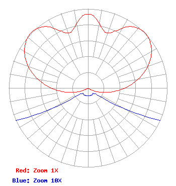 | |||||||||||||||||||
| Azimuth | Ratio | Azimuth | Ratio | Azimuth | Ratio | Azimuth | Ratio | |||||||||||||
| 0 | 0.933 | 5 | 0.902 | 15 | 0.756 | 20 | 0.740 | |||||||||||||
| 25 | 0.793 | 35 | 0.947 | 45 | 1.000 | 55 | 0.967 | |||||||||||||
| 65 | 0.872 | 75 | 0.729 | 85 | 0.556 | 95 | 0.378 | |||||||||||||
| 105 | 0.218 | 115 | 0.094 | 125 | 0.021 | 135 | 0.010 | |||||||||||||
| 145 | 0.010 | 155 | 0.010 | 165 | 0.010 | 175 | 0.010 | |||||||||||||
| 185 | 0.010 | 195 | 0.010 | 205 | 0.010 | 215 | 0.010 | |||||||||||||
| 225 | 0.010 | 235 | 0.021 | 245 | 0.094 | 255 | 0.218 | |||||||||||||
| 265 | 0.378 | 275 | 0.556 | 285 | 0.729 | 295 | 0.872 | |||||||||||||
| 305 | 0.967 | 315 | 1.000 | 325 | 0.947 | 335 | 0.793 | |||||||||||||
| 340 | 0.740 | 345 | 0.756 | 355 | 0.902 | |||||||||||||||
Structure Registration Number 1008484 Structure Type: TOWER Registered To: Pinnacle Towers LLC Structure Address: End Of Coldwater St Valdese, NC County Name: Burke County ASR Issued: 05/06/2016 Date Built: 02/01/1985 Site Elevation: 641 m (2103 ft.) Structure Height: 103.6 m (340 ft.) Height Overall: 106.1 m (348 ft.) Overall Height AMSL: 747.1 m (2451 ft.) FAA Determination: 12/16/2009 FAA Study #: 2009-ASO-6342-OE FAA Circular #: 70/7460-1K Paint & Light FAA Chapters: 4, 6, 12 PRIOR STUDY 2009-ASO-3519-OE 35-42-33.0 N 81-31-31.9 W (NAD 83) 35-42-32.5 N 81-31-32.6 W (Converted to NAD 27) |
C/o Amy Elizabeth Pittenger One Television Place Charlotte, NC 28205 Phone: 704-632-7227 General Partnership | Title: President Of Managing Partner Of North Carolina Broadcasting Partners Date: 10/17/2019 Application Certifier North Carolina Broadcasting Partners C/o Amy Elizabeth Pittenger One Television Place Charlotte, NC 28205 Applicant Louis R duTreil, Jr Dutreil Lundin & Rackley Inc 3135 Southgate Circle Sarasota, FL 34239 Technical Consultant M. Anne Swanson Wilkinson Barker Knauer, Llp 1800 M Street, Nw Suite 800n Washington, DC 20036 | ||||||||||||||||||