
FCCInfo.com
A Service of Cavell, Mertz & Associates, Inc.
(855) FCC-INFO
|
|
WQWQ-LD from 04/11/2000 WQWQ-LD from 11/10/1999 WQWQ-LD from 09/09/1998 |
|
|
||||||||||||||||
|
|
Status: STA – Special Temporary Authority Application Accepted: 12/16/2019 STA Expires: 12/25/2019 File Number: -0000093437 FCC Website Links: LMS Facility Details This Application Other WQWQ-LD Applications Including Superseded Applications Mailing Address Correspondence for WQWQ-LD Correspondence related to application -0000093437 Service Contour - Open Street Map or USGS Map (68 dBu) Service Contour - KML / Google Earth (68 dBu) Rabbit Ears Info Search for WQWQ-LD Site Location: 37-02-54.5 N 88-35-41.4 W (NAD 83) Site Location: 37-02-54.3 N 88-35-41.2 W (Converted to NAD 27) ERP: 3 kW R/C AGL: 95.6 m (314 ft.) R/C AMSL: 198 m (650 ft.) Site Elevation: 102.4 m. (336 ft.) Height Overall*: 103.6 m (340 ft.) (* As Filed In This Application, may differ from ASR Data, Below.) Directional Antenna - Antenna Make/Model: Propagation System Inc ODDWQWQ-LP Antenna ID: 38405 | ||||||||||||||||||
| Antenna Data for Antenna Id: 38405 WQWQ-LD TX File: -0000093437 Propagation System Inc - ODDWQWQ-LP Service: TX Standard Pattern: Y | 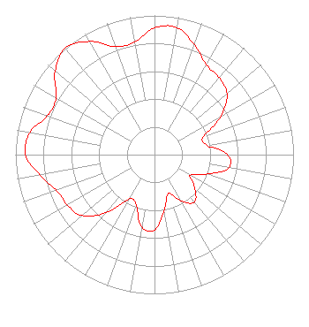 | ||||||||||||||||||
| Azimuth | Ratio | Azimuth | Ratio | Azimuth | Ratio | Azimuth | Ratio | ||||||||||||
| 0 | 0.910 | 10 | 0.928 | 20 | 0.839 | 30 | 0.747 | ||||||||||||
| 40 | 0.722 | 50 | 0.681 | 60 | 0.551 | 70 | 0.373 | ||||||||||||
| 80 | 0.383 | 90 | 0.524 | 100 | 0.543 | 110 | 0.408 | ||||||||||||
| 120 | 0.295 | 130 | 0.379 | 140 | 0.446 | 150 | 0.383 | ||||||||||||
| 160 | 0.296 | 170 | 0.403 | 180 | 0.541 | 190 | 0.527 | ||||||||||||
| 200 | 0.385 | 210 | 0.369 | 220 | 0.546 | 230 | 0.681 | ||||||||||||
| 240 | 0.725 | 250 | 0.750 | 260 | 0.839 | 270 | 0.928 | ||||||||||||
| 280 | 0.910 | 290 | 0.818 | 300 | 0.818 | 310 | 0.933 | ||||||||||||
| 320 | 1.000 | 330 | 0.939 | 340 | 0.825 | 350 | 0.821 | ||||||||||||
Structure Registration Number 1215850 Structure Type: TOWER Registered To: SBA Properties, LLC Structure Address: 2030 W Hovekamp Rd Paducah, KY County Name: McCracken County ASR Issued: 04/25/2013 Date Built: 09/07/2000 Site Elevation: 102.4 m (336 ft.) Structure Height: 103.6 m (340 ft.) Height Overall: 103.6 m (340 ft.) Overall Height AMSL: 206 m (676 ft.) FAA Determination: 07/07/2000 FAA Study #: 00-ASO-3649-OE FAA Circular #: 70/7460-1K Paint & Light FAA Chapters: 4, 8, 12 Removed expiration date from determination. Scenario 1./jjs/case#635066 37-02-54.5 N 88-35-41.4 W (NAD 83) 37-02-54.3 N 88-35-41.2 W (Converted to NAD 27) |
4370 Peachtree Road, Ne Atlanta, GA 30319 Phone: 404-504-9828 Limited Liability Company | Title: Assistant Secretary Date: 12/16/2019 Application Certifier Gray Television Licensee, Llc 4370 Peachtree Road, Ne Atlanta, GA 30319 Applicant Joan Stewart Wiley Rein Llp 1776 K Street, Nw Washington, DC 20006 | |||||||||||||||||