
FCCInfo.com
A Service of Cavell, Mertz & Associates, Inc.
(855) FCC-INFO
|
|
WQXT-CD from 07/22/2002 WQXT-CD from 01/14/1988 |
Post-repack Channel 29 |
|
||||||||||||||||
|
|
Repacking Information: Pre-Repack Channel: 28 Post-Repack Channel: 29 Post-Repack ERP: 15 kW Phase: 7 Completion Deadline: 1/17/2020 Upstream/Downstream Dependencies Other Linked Stations Find nearby TV Facilities Status: License Application Accepted: 01/21/2020 License Expires: 02/01/2021 File Number: -0000098976 FCC Website Links: LMS Facility Details This Application Other WQXT-CD Applications Including Superseded Applications Mailing Address Correspondence for WQXT-CD Correspondence related to application -0000098976 Service Contour - Open Street Map or USGS Map (51 dBu) Service Contour - KML / Google Earth (51 dBu) Public Inspection Files Rabbit Ears Info Search for WQXT-CD Site Location: 29-54-14.7 N 81-22-55.9 W (NAD 83) Site Location: 29-54-13.8 N 81-22-56.6 W (Converted to NAD 27) ERP: 15 kW Polarization: Horizontally polarized R/C AGL: 117.8 m (386 ft.) R/C AMSL: 128.5 m (422 ft.) Emission Mask: Stringent Site Elevation: 11 m. (36 ft.) Height Overall*: 120.4 m (395 ft.) (* As Filed In This Application, may differ from ASR Data, Below.) Directional Antenna - Antenna Make/Model: DIELECTRIC TUAM-6/12-C2SP Antenna ID: 1006267 Polarization: Horizontally polarized | ||||||||||||||||||
| Antenna Data for Antenna Id: 1006267 WQXT-CD DC File: -0000098976 DIELECTRIC - TUAM-6/12-C2SP Service: DC Standard Pattern: N Pattern and Field Values Include a 340° Clockwise Rotation | 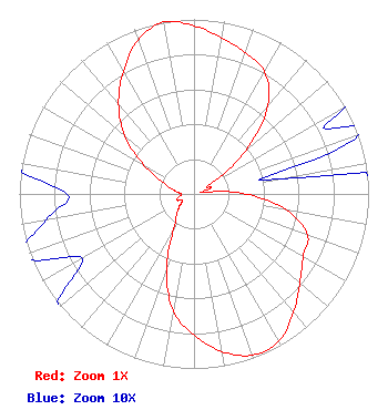 | ||||||||||||||||||
| Azimuth | Ratio | Azimuth | Ratio | Azimuth | Ratio | Azimuth | Ratio | ||||||||||||
| 0 | 0.963 | 10 | 0.908 | 20 | 0.861 | 30 | 0.808 | ||||||||||||
| 40 | 0.659 | 50 | 0.392 | 60 | 0.107 | 70 | 0.101 | ||||||||||||
| 80 | 0.049 | 90 | 0.299 | 100 | 0.539 | 110 | 0.691 | ||||||||||||
| 120 | 0.721 | 130 | 0.791 | 140 | 0.885 | 150 | 0.974 | ||||||||||||
| 160 | 0.983 | 170 | 0.917 | 180 | 0.808 | 190 | 0.683 | ||||||||||||
| 200 | 0.461 | 210 | 0.234 | 220 | 0.158 | 230 | 0.108 | ||||||||||||
| 240 | 0.074 | 250 | 0.104 | 260 | 0.086 | 270 | 0.073 | ||||||||||||
| 280 | 0.116 | 290 | 0.188 | 300 | 0.330 | 310 | 0.517 | ||||||||||||
| 320 | 0.672 | 330 | 0.811 | 340 | 0.938 | 350 | 1.000 | ||||||||||||
Structure Registration Number 1034197 Structure Type: GTOWER Registered To: SBA Towers II LLC Structure Address: 3050 Industry Center Rd (fl12271-a) St. Augustine, FL County Name: St. Johns County ASR Issued: 04/15/2019 Date Built: 01/01/1987 Site Elevation: 11 m (36 ft.) Structure Height: 118.9 m (390 ft.) Height Overall: 120.4 m (395 ft.) Overall Height AMSL: 131.4 m (431 ft.) FAA Determination: 04/14/2019 FAA Study #: 2018-ASO-21477-OE FAA Circular #: 70/7460-1L Paint & Light FAA Chapters: 4, 8, 12 PRIOR STUDY 1987-ASO-810-OE 29-54-14.7 N 81-22-55.9 W (NAD 83) 29-54-13.8 N 81-22-56.6 W (Converted to NAD 27) |
126 Hercules Road St. Augustine, FL 32086 Phone: 904-794-6774 Corporation | Title: President Date: 01/21/2020 Application Certifier A1A TV, INC. A1a Tv, Inc. 126 Hercules Road St. Augustine, FL 32086 Applicant Benjamin Perez Abacus Communications Company 514 Chautauqua Street Pittsburgh, PA 15214 Davina Sashkin Fletcher, Heald & Hildreth, P.l.c. 1300 N. 17th St. 11th Floor Arlington, VA 22209 Legal Counsel | |||||||||||||||||
| |||||||||||||||||||