
FCCInfo.com
A Service of Cavell, Mertz & Associates, Inc.
(855) FCC-INFO
|
|
WKDC-LD from 10/13/2010 WKDC-LD from 06/02/2008 WKDC-LD from 04/26/2002 WKDC-LD from 08/21/1990 |
|
|
|||||||||||||||||
|
|
Status: License Application Accepted: 02/19/2020 License Expires: 12/01/2020 File Number: -0000106264 FCC Website Links: LMS Facility Details This Application Other WKDC-LD Applications Including Superseded Applications Mailing Address Correspondence for WKDC-LD Correspondence related to application -0000106264 Service Contour - Open Street Map or USGS Map (51 dBu) Service Contour - KML / Google Earth (51 dBu) Rabbit Ears Info Search for WKDC-LD Site Location: 34-06-58.4 N 80-45-49.9 W (NAD 83) Site Location: 34-06-57.9 N 80-45-50.6 W (Converted to NAD 27) ERP: 15 kW Polarization: Horizontally polarized Electrical Beam Tilt: 1 degree R/C AGL: 122 m (400 ft.) R/C AMSL: 208.8 m (685 ft.) Emission Mask: Stringent Site Elevation: 86.8 m. (285 ft.) Height Overall*: 537.7 m (1764 ft.) (* As Filed In This Application, may differ from ASR Data, Below.) Directional Antenna - Antenna Make/Model: Systems With Reliability Inc. SWLP8WC Antenna ID: 68000 Polarization: Horizontally polarized
| |||||||||||||||||||
| Antenna Data for Antenna Id: 68000 WKDC-LD LD File: -0000106264 Systems With Reliability Inc. - SWLP8WC Service: LD Standard Pattern: Y Pattern and Field Values Include a 195° Clockwise Rotation | 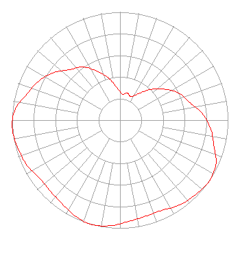 | |||||||||||||||||||
| Azimuth | Ratio | Azimuth | Ratio | Azimuth | Ratio | Azimuth | Ratio | |||||||||||||
| 5 | 0.240 | 15 | 0.260 | 25 | 0.240 | 35 | 0.300 | |||||||||||||
| 45 | 0.400 | 55 | 0.500 | 65 | 0.600 | 75 | 0.660 | |||||||||||||
| 85 | 0.760 | 95 | 0.840 | 105 | 0.900 | 115 | 0.980 | |||||||||||||
| 125 | 1.000 | 135 | 0.980 | 145 | 0.960 | 155 | 0.920 | |||||||||||||
| 165 | 0.920 | 175 | 0.940 | 185 | 0.980 | 195 | 1.000 | |||||||||||||
| 205 | 0.980 | 215 | 0.940 | 225 | 0.920 | 235 | 0.920 | |||||||||||||
| 245 | 0.960 | 255 | 0.980 | 265 | 1.000 | 275 | 0.980 | |||||||||||||
| 285 | 0.900 | 295 | 0.840 | 305 | 0.760 | 315 | 0.660 | |||||||||||||
| 325 | 0.600 | 335 | 0.500 | 345 | 0.400 | 355 | 0.300 | |||||||||||||
Structure Registration Number 1055358 Structure Type: GTOWER Registered To: American Towers LLC Structure Address: 1811 Rush Rd (#023657) Elgin, SC County Name: Kershaw County ASR Issued: 08/23/2023 Date Built: 03/05/2001 Site Elevation: 86.8 m (285 ft.) Structure Height: 516.9 m (1696 ft.) Height Overall: 537.7 m (1764 ft.) Overall Height AMSL: 624.5 m (2049 ft.) FAA Determination: 04/07/2023 FAA Study #: 2022-ASO-44876-OE FAA Circular #: 70/7460-1M Paint & Light FAA Chapters: 4, 9, 15 PRIOR STUDY 2006-ASO-728-OE 34-06-58.4 N 80-45-49.9 W (NAD 83) 34-06-57.9 N 80-45-50.6 W (Converted to NAD 27) |
3901 Highway 121 Bedford, TX 76021 Phone: 817-571-1229 Not-for-Profit | Title: President Date: 02/19/2020 Application Certifier Word Of God Fellowship, Inc. 3901 Highway 121 Bedford, TX 76021 Applicant Ari Meltzer, Esq Wiley Rein Llp 1776 K Street, N.w. Washington, DC 20006 RICHARD C. GOETZ R & L Media Systems 135 N. Country Club Dr. Hendersonville, TN 37075 BROADCAST CONSULTANT | ||||||||||||||||||