
FCCInfo.com
A Service of Cavell, Mertz & Associates, Inc.
(855) FCC-INFO
|
|
KRHD-CD from 11/14/1997 KRHD-CD from 06/15/1990 |
Post-repack Channel 15 Virtual Channel 40 |
|
||||||||||||||||
|
|
Repacking Information: Pre-Repack Channel: 40 Post-Repack Channel: 15 Post-Repack ERP: 8.69 kW Phase: 8 Completion Deadline: 3/13/2020 Find nearby TV Facilities Status: License Application Accepted: 03/16/2020 License Expires: 08/01/2022 File Number: -0000108095 FCC Website Links: LMS Facility Details This Application Other KRHD-CD Applications Including Superseded Applications Mailing Address Correspondence for KRHD-CD Correspondence related to application -0000108095 Service Contour - Open Street Map or USGS Map (51 dBu) Service Contour - KML / Google Earth (51 dBu) Public Inspection Files Rabbit Ears Info Search for KRHD-CD Site Location: 30-45-26.8 N 96-28-04.6 W (NAD 83) Site Location: 30-45-26.1 N 96-28-03.7 W (Converted to NAD 27) ERP: 12 kW Polarization: Elliptically polarized Electrical Beam Tilt: 1 degree R/C AGL: 127.7 m (419 ft.) R/C AMSL: 240.2 m (788 ft.) Emission Mask: Stringent Site Elevation: 112.5 m. (369 ft.) Height Overall*: 152 m (499 ft.) (* As Filed In This Application, may differ from ASR Data, Below.) Directional Antenna - Antenna Make/Model: DIELECTRIC TLP12C/VP Antenna ID: 1006564 Polarization: Elliptically polarized | ||||||||||||||||||
| Antenna Data for Antenna Id: 1006564 KRHD-CD DC File: -0000108095 DIELECTRIC - TLP12C/VP Service: DC Standard Pattern: N Pattern and Field Values Include a 172° Clockwise Rotation | 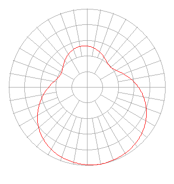 | ||||||||||||||||||
| Azimuth | Ratio | Azimuth | Ratio | Azimuth | Ratio | Azimuth | Ratio | ||||||||||||
| 2 | 0.522 | 12 | 0.500 | 22 | 0.467 | 32 | 0.430 | ||||||||||||
| 42 | 0.400 | 52 | 0.398 | 62 | 0.440 | 72 | 0.510 | ||||||||||||
| 82 | 0.590 | 92 | 0.671 | 102 | 0.748 | 112 | 0.818 | ||||||||||||
| 122 | 0.877 | 132 | 0.924 | 142 | 0.958 | 152 | 0.980 | ||||||||||||
| 162 | 0.994 | 172 | 1.000 | 182 | 0.990 | 192 | 0.973 | ||||||||||||
| 202 | 0.946 | 212 | 0.907 | 222 | 0.857 | 232 | 0.792 | ||||||||||||
| 242 | 0.713 | 252 | 0.628 | 262 | 0.547 | 272 | 0.474 | ||||||||||||
| 282 | 0.414 | 292 | 0.378 | 302 | 0.378 | 312 | 0.408 | ||||||||||||
| 322 | 0.449 | 332 | 0.487 | 342 | 0.515 | 352 | 0.527 | ||||||||||||
Structure Registration Number 1044896 Structure Type: GTOWER Registered To: American Towers LLC Structure Address: Hwy 6 Benchley (374768) Bryan, TX County Name: Robertson County ASR Issued: 05/12/2017 Date Built: 01/25/1983 Site Elevation: 112.5 m (369 ft.) Structure Height: 146 m (479 ft.) Height Overall: 152 m (499 ft.) Overall Height AMSL: 264.5 m (868 ft.) FAA Determination: 05/01/2017 FAA Study #: 2017-ASW-5119-OE FAA Circular #: 70/7460-1K Paint & Light FAA Chapters: 4, 6, 12 PRIOR STUDY 2015-ASW-712-OE 30-45-26.8 N 96-28-04.6 W (NAD 83) 30-45-26.1 N 96-28-03.7 W (Converted to NAD 27) |
312 Walnut Street 28th Floor Cincinnati, OH 45202 Phone: 513-977-3000 Limited Liability Company | Title: Vice President/engineering Date: 03/16/2020 Application Certifier SCRIPPS BROADCASTING HOLDINGS LLC Scripps Broadcasting Holdings Llc 312 Walnut Street 28th Floor Cincinnati, OH 45202 Applicant KENNETH HOWARD, JR Baker & Hostetler Llp 1050 Connecticut Avenue N.w. Suite 1100 Washington, DC 20036 Legal Representative BENJAMIN PIDEK, P.E. Mid-state Consultants 6197 Miller Rd Suite 1 Swartz Creek, MI 48473 CONSULTING ENGINEER | |||||||||||||||||
| |||||||||||||||||||