
FCCInfo.com
A Service of Cavell, Mertz & Associates, Inc.
(855) FCC-INFO
|
|
KCKS-LD from 12/13/2011 |
Virtual Channel 25 |
|
||||||||||||||||
|
|
Status: License (Licensed And Reduced Power) Application Accepted: 04/22/2020 License Expires: 06/01/2022 File Number: -0000112569 FCC Website Links: LMS Facility Details This Application Other KCKS-LD Applications Including Superseded Applications Mailing Address Correspondence for KCKS-LD Correspondence related to application -0000112569 Service Contour - Open Street Map or USGS Map (51 dBu) Service Contour - KML / Google Earth (51 dBu) Rabbit Ears Info Search for KCKS-LD Site Location: 39-08-58.0 N 94-56-45.0 W (NAD 83) Site Location: 39-08-58.0 N 94-56-44.1 W (Converted to NAD 27) ERP: 15 kW Polarization: Horizontally polarized R/C AGL: 274 m (899 ft.) R/C AMSL: 566.6 m (1859 ft.) Emission Mask: Full Service Site Elevation: 292.6 m. (960 ft.) Height Overall*: 301.8 m (990 ft.) (* As Filed In This Application, may differ from ASR Data, Below.) Directional Antenna - Antenna Make/Model: Systems With Reliability Inc. SWLP18OI Antenna ID: 1006706 Polarization: Horizontally polarized | ||||||||||||||||||
| Antenna Data for Antenna Id: 1006706 KCKS-LD LD File: -0000112569 Systems With Reliability Inc. - SWLP18OI Service: LD Standard Pattern: N Pattern and Field Values Include a 90° Clockwise Rotation | 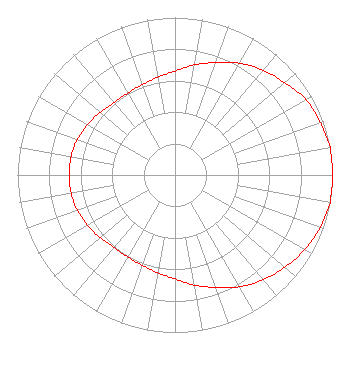 | ||||||||||||||||||
| Azimuth | Ratio | Azimuth | Ratio | Azimuth | Ratio | Azimuth | Ratio | ||||||||||||
| 0 | 0.660 | 10 | 0.710 | 20 | 0.760 | 30 | 0.820 | ||||||||||||
| 40 | 0.870 | 50 | 0.910 | 60 | 0.960 | 70 | 0.980 | ||||||||||||
| 80 | 1.000 | 90 | 1.000 | 100 | 1.000 | 110 | 0.980 | ||||||||||||
| 120 | 0.950 | 130 | 0.910 | 140 | 0.870 | 150 | 0.820 | ||||||||||||
| 160 | 0.760 | 170 | 0.710 | 180 | 0.660 | 190 | 0.630 | ||||||||||||
| 200 | 0.610 | 210 | 0.600 | 220 | 0.600 | 230 | 0.620 | ||||||||||||
| 240 | 0.640 | 250 | 0.660 | 260 | 0.670 | 270 | 0.670 | ||||||||||||
| 280 | 0.670 | 290 | 0.660 | 300 | 0.640 | 310 | 0.620 | ||||||||||||
| 320 | 0.600 | 330 | 0.600 | 340 | 0.610 | 350 | 0.630 | ||||||||||||
Structure Registration Number 1033284 Structure Type: TOWER Registered To: Lyons Wireless Group, LLC Structure Address: Near 155th & Leavenworth Rd Basehor, KS County Name: Leavenworth County ASR Issued: 02/04/2022 Date Built: 01/01/1981 Site Elevation: 292.6 m (960 ft.) Structure Height: 301.8 m (990 ft.) Height Overall: 301.8 m (990 ft.) Overall Height AMSL: 594.4 m (1950 ft.) FAA Determination: 10/12/1982 FAA Study #: 81-ACE-968-OE FAA Circular #: 70/7460-1F Paint & Light FAA Chapters: 3, 4, 5, 6, 9 PAINT WITH DUAL HIGH INTENSITY WHITE STROBES AND RED LIGHTS. 39-08-58.0 N 94-56-45.0 W (NAD 83) 39-08-58.0 N 94-56-44.1 W (Converted to NAD 27) |
Po Box 5307 Topeka, KS 66605 Phone: 785-266-3999 Limited Liability Company | Title: President Date: 04/22/2020 Application Certifier HEARTLAND BROADCASTING LLC Heartland Broadcasting Llc Po Box 5307 Topeka, KS 66605 Applicant Robert C. Nall Heartland Broadcasting, Llc Po Box 5307 Topeka, KS 66605 CEO | |||||||||||||||||