
FCCInfo.com
A Service of Cavell, Mertz & Associates, Inc.
(855) FCC-INFO
|
|
KPIF from 02/16/2011 KPIF from 12/17/2003 |
Virtual Channel 15 |  |
|
|||||||||||||||
|
|
Repacking Information: No changes Status: License Application Accepted: 04/28/2020 License Expires: 07/10/2019 File Number: -0000112831 FCC Website Links: LMS Facility Details This Application Other KPIF Applications Including Superseded Applications Mailing Address Correspondence for KPIF Correspondence related to application -0000112831 Service Contour - Open Street Map or USGS Map (41 dBu) Service Contour - KML / Google Earth (41 dBu) Public Inspection Files Rabbit Ears Info Search for KPIF Site Location: 42-51-50.1 N 112-31-13.3 W (NAD 83) Site Location: 42-51-50.4 N 112-31-10.4 W (Converted to NAD 27) ERP: 288 kW Polarization: Elliptically polarized HAAT: 331.1 m (1086 ft.) Electrical Beam Tilt: 1.0 degree R/C AGL: 86.4 m (283 ft.) R/C AMSL: 1857 m (6093 ft.) Site Elevation: 1770.6 m. (5809 ft.) Height Overall*: 92.4 m (303 ft.) (* As Filed In This Application, may differ from ASR Data, Below.) Directional Antenna - Antenna Make/Model: Alive ATC-BCSE20C2S-U Antenna ID: 1002145 Polarization: Elliptically polarized | ||||||||||||||||||
| Antenna Data for Antenna Id: 1002145 KPIF DT File: -0000112831 Alive - ATC-BCSE20C2S-U Service: DT Standard Pattern: Y | 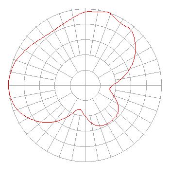 | ||||||||||||||||||
| Azimuth | Ratio | Azimuth | Ratio | Azimuth | Ratio | Azimuth | Ratio | ||||||||||||
| 0 | 0.954 | 10 | 0.968 | 19 | 1.000 | 20 | 0.982 | ||||||||||||
| 30 | 0.934 | 40 | 0.934 | 50 | 0.856 | 60 | 0.751 | ||||||||||||
| 70 | 0.624 | 80 | 0.487 | 90 | 0.367 | 98 | 0.325 | ||||||||||||
| 100 | 0.327 | 110 | 0.393 | 120 | 0.494 | 130 | 0.562 | ||||||||||||
| 140 | 0.580 | 150 | 0.582 | 160 | 0.565 | 170 | 0.503 | ||||||||||||
| 180 | 0.402 | 190 | 0.329 | 192 | 0.325 | 200 | 0.358 | ||||||||||||
| 210 | 0.486 | 220 | 0.624 | 230 | 0.750 | 240 | 0.855 | ||||||||||||
| 250 | 0.940 | 260 | 0.985 | 270 | 1.000 | 280 | 0.985 | ||||||||||||
| 290 | 0.954 | 300 | 0.903 | 310 | 0.859 | 320 | 0.827 | ||||||||||||
| 330 | 0.820 | 340 | 0.846 | 350 | 0.893 | ||||||||||||||
Structure Registration Number 1239956 Structure Type: TOWER Registered To: MM Shirin Properties, LLC Structure Address: Howard Mt. Lot 12, Power County Pocatello, ID County Name: Power County ASR Issued: 03/12/2019 Date Built: 11/06/2003 Site Elevation: 1770.6 m (5809 ft.) Structure Height: 91.4 m (300 ft.) Height Overall: 92.4 m (303 ft.) Overall Height AMSL: 1863 m (6112 ft.) FAA Determination: 06/30/2003 FAA Study #: 2003-ANM-1166-OE FAA Circular #: 70/7460-1K Paint & Light FAA Chapters: 3, 4, 5, 12 42-51-50.1 N 112-31-13.3 W (NAD 83) 42-51-50.4 N 112-31-10.4 W (Converted to NAD 27) |
Fresno, CA 93702 Phone: 866-436-6388 Limited Liability Company | Title: Vice President Date: 04/28/2020 Application Certifier VENTURA MEDIA COMMUNICATIONS, L.L.C Ventura Media Communications, L.l.c. Fresno, CA 93702 Applicant W. JEFFREY REYNOLDS Du Treil, Lundin & Rackley, Inc. 3135 Southgate Circle Sarasota, FL 34293 TECHNICAL CONSULTANT KATHLEEN VICTORY Fletcher Heald & Hildreth, Plc 1300 N. 17th Street Sutie 1100 Arlington, VA 22209 FCC COUNSEL | |||||||||||||||||
| |||||||||||||||||||