
FCCInfo.com
A Service of Cavell, Mertz & Associates, Inc.
(855) FCC-INFO
|
|
KUTU-CD from 01/10/2005 KUTU-CD from 12/20/1996 KUTU-CD from 12/30/1994 |
Post-repack Channel 17 |
|
||||||||||||||||
|
|
Repacking Information: Pre-Repack Channel: 25 Post-Repack Channel: 17 Post-Repack ERP: 6.55 kW Phase: 9 Completion Deadline: 5/1/2020 Upstream/Downstream Dependencies Other Linked Stations Find nearby TV Facilities Status: License Application Accepted: 07/17/2020 License Expires: 06/01/2022 File Number: -0000117970 FCC Website Links: LMS Facility Details This Application Other KUTU-CD Applications Including Superseded Applications Mailing Address Correspondence for KUTU-CD Correspondence related to application -0000117970 Service Contour - Open Street Map or USGS Map (51 dBu) Service Contour - KML / Google Earth (51 dBu) Public Inspection Files Rabbit Ears Info Search for KUTU-CD Site Location: 36-09-01.0 N 95-59-26.1 W (NAD 83) Site Location: 36-09-00.7 N 95-59-25.1 W (Converted to NAD 27) ERP: 6.55 kW Polarization: Horizontally polarized Electrical Beam Tilt: 1 degree R/C AGL: 132.7 m (435 ft.) R/C AMSL: 355.9 m (1168 ft.) Emission Mask: Stringent Site Elevation: 223.2 m. (732 ft.) Height Overall*: 135.7 m (445 ft.) (* As Filed In This Application, may differ from ASR Data, Below.) Directional Antenna - Antenna Make/Model: Systems With Reliability Inc. SWEDL8WC/17 Antenna ID: 1007094 Polarization: Horizontally polarized | ||||||||||||||||||
| Antenna Data for Antenna Id: 1007094 KUTU-CD DC File: -0000117970 Systems With Reliability Inc. - SWEDL8WC/17 Service: DC Standard Pattern: N Pattern and Field Values Include a 70° Clockwise Rotation | 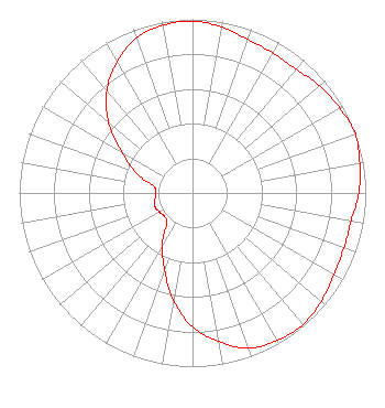 | ||||||||||||||||||
| Azimuth | Ratio | Azimuth | Ratio | Azimuth | Ratio | Azimuth | Ratio | ||||||||||||
| 0 | 0.990 | 10 | 0.970 | 20 | 0.940 | 30 | 0.930 | ||||||||||||
| 40 | 0.930 | 50 | 0.960 | 60 | 0.980 | 70 | 1.000 | ||||||||||||
| 80 | 0.980 | 90 | 0.960 | 100 | 0.930 | 110 | 0.930 | ||||||||||||
| 120 | 0.940 | 130 | 0.970 | 140 | 0.990 | 150 | 0.980 | ||||||||||||
| 160 | 0.950 | 170 | 0.870 | 180 | 0.770 | 190 | 0.630 | ||||||||||||
| 200 | 0.470 | 210 | 0.350 | 220 | 0.230 | 230 | 0.210 | ||||||||||||
| 240 | 0.220 | 250 | 0.230 | 260 | 0.220 | 270 | 0.210 | ||||||||||||
| 280 | 0.230 | 290 | 0.350 | 300 | 0.470 | 310 | 0.630 | ||||||||||||
| 320 | 0.770 | 330 | 0.870 | 340 | 0.950 | 350 | 0.980 | ||||||||||||
Structure Registration Number 1277286 Structure Type: B Registered To: BOA Building (LLC) Structure Address: 15 W 6th Street Tulsa, OK County Name: Tulsa County ASR Issued: 01/06/2011 Site Elevation: 223.2 m (732 ft.) Structure Height: 125.5 m (412 ft.) Height Overall: 135.7 m (445 ft.) Overall Height AMSL: 358.9 m (1177 ft.) FAA Determination: 12/14/2010 FAA Study #: 2010-ASW-6068-OE FAA Circular #: Paint & Light FAA Chapters: NONE 36-09-01.0 N 95-59-26.1 W (NAD 83) 36-09-00.7 N 95-59-25.1 W (Converted to NAD 27) |
5101 S. Shields Blvd. Oklahoma City, OK 73129 Phone: 405-616-5500 Limited Liability Company | Title: Manager Date: 07/17/2020 Application Certifier TYLER MEDIA LLC Tyler Media Llc 5101 S. Shields Blvd. Oklahoma City, OK 73129 Applicant SCOTT BENTON Tyler Media, L.l.c. 5101 S. Shields Blvd. Oklahoma City, OK 73129 Chief Engineer JOHN CHARLES TRENT, ESQ Putbrese Hunsaker & Trent, P.c. Putbrese Hunsaker & Trent, P.c. 200 South Church Street Woodstock, VA 22664 COUNSEL | |||||||||||||||||