
FCCInfo.com
A Service of Cavell, Mertz & Associates, Inc.
(855) FCC-INFO
|
|
|
Virtual Channel 10 |  |
|
||||||||||||||||||
|
|
Repacking Information: No changes Status: License Application Accepted: 10/13/2015 License Expires: 10/01/2021 File Number: -0000004980 FCC Website Links: LMS Facility Details This Application Other WBUP Applications Including Superseded Applications Mailing Address Correspondence for WBUP Correspondence related to application -0000004980 Service Contour - Open Street Map or USGS Map (36 dBu) Service Contour - KML / Google Earth (36 dBu) Public Inspection Files Rabbit Ears Info Search for WBUP Site Location: 46-29-26.1 N 87-53-36.5 W (NAD 83) Site Location: 46-29-26.3 N 87-53-36.0 W (Converted to NAD 27) ERP: 9 kW Polarization: Horizontally polarized HAAT: 235 m (771 ft.) Electrical Beam Tilt: 0.5 degrees R/C AGL: 179 m (587 ft.) R/C AMSL: 715.8 m (2348 ft.) Site Elevation: 536.8 m. (1761 ft.) Height Overall*: 184.4 m (605 ft.) (* As Filed In This Application, may differ from ASR Data, Below.) Directional Antenna - Antenna Make/Model: R.F. Systems B4VA(M) Antenna ID: 117005 Polarization: Horizontally polarized | |||||||||||||||||||||
| Antenna Data for Antenna Id: 117005 WBUP DT File: -0000004980 R.F. Systems - B4VA(M) Service: DT Standard Pattern: Y Pattern and Field Values Include a 140° Clockwise Rotation | 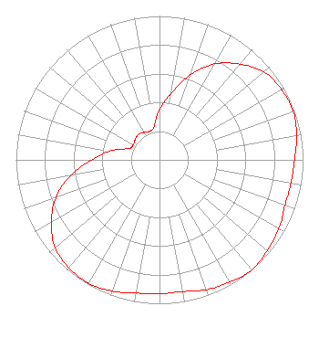 | |||||||||||||||||||||
| Azimuth | Ratio | Azimuth | Ratio | Azimuth | Ratio | Azimuth | Ratio | |||||||||||||||
| 0 | 0.350 | 10 | 0.470 | 20 | 0.630 | 30 | 0.770 | |||||||||||||||
| 40 | 0.870 | 50 | 0.950 | 60 | 0.980 | 70 | 0.990 | |||||||||||||||
| 80 | 0.970 | 90 | 0.940 | 100 | 0.930 | 110 | 0.930 | |||||||||||||||
| 120 | 0.960 | 130 | 0.980 | 140 | 1.000 | 150 | 0.980 | |||||||||||||||
| 160 | 0.960 | 170 | 0.930 | 180 | 0.930 | 190 | 0.940 | |||||||||||||||
| 200 | 0.970 | 210 | 0.990 | 220 | 0.980 | 230 | 0.950 | |||||||||||||||
| 240 | 0.870 | 250 | 0.770 | 260 | 0.630 | 270 | 0.470 | |||||||||||||||
| 280 | 0.350 | 290 | 0.230 | 300 | 0.210 | 310 | 0.220 | |||||||||||||||
| 320 | 0.230 | 330 | 0.220 | 340 | 0.210 | 350 | 0.230 | |||||||||||||||
Structure Registration Number 1270843 Structure Type: TOWER Registered To: Queen Bee's Knees, LLC Structure Address: Humboldt Humboldt, MI County Name: Marquette County ASR Issued: 12/13/2023 Site Elevation: 536.8 m (1761 ft.) Structure Height: 182 m (597 ft.) Height Overall: 184.4 m (605 ft.) Overall Height AMSL: 721.2 m (2366 ft.) FAA Determination: 03/13/2009 FAA Study #: 2009-AGL-818-OE FAA Circular #: 70/7460-1K Paint & Light FAA Chapters: 4, 9, 12 Removed expiration date from determination. Scenario 1./jjs/case#635066 46-29-26.1 N 87-53-36.5 W (NAD 83) 46-29-26.3 N 87-53-36.0 W (Converted to NAD 27) |
7025 Raymond Road Madison, WI 53719 Phone: 608-271-4321 Limited Liability Company | Title: President Date: 10/13/2015 Application Certifier LAKE SUPERIOR COMMUNITY BROADCASTING CORPORATION Lake Superior Community Broadcasting Corporation 1390 Bagley Street Alpena, MI 49707 Applicant David D. Oxenford Wilkinson Barker Knauer, Llp 1800 M Street Suite 800n Washington, DC 20036 Jeremy D. Ruck Jeremy Ruck & Associates, Inc. P.o. Box 415 Canton, IL 61520 CONSULTING ENGINEER | ||||||||||||||||||||
| ||||||||||||||||||||||