
FCCInfo.com
A Service of Cavell, Mertz & Associates, Inc.
(855) FCC-INFO
|
|
KAUO-LD from 02/25/2010 |
|
|
||||||||||||||||
|
|
Status: License Application Accepted: 06/20/2016 License Expires: 08/01/2022 File Number: -0000011234 FCC Website Links: LMS Facility Details This Application Other KAUO-LD Applications Including Superseded Applications Mailing Address Correspondence for KAUO-LD Correspondence related to application -0000011234 Service Contour - Open Street Map or USGS Map (51 dBu) Service Contour - KML / Google Earth (51 dBu) Rabbit Ears Info Search for KAUO-LD Site Location: 35-10-25.9 N 101-57-14.5 W (NAD 83) Site Location: 35-10-25.7 N 101-57-12.8 W (Converted to NAD 27) ERP: 3 kW Polarization: Horizontally polarized R/C AGL: 103.6 m (340 ft.) R/C AMSL: 1254.5 m (4116 ft.) Emission Mask: Full Service Site Elevation: 1150.9 m. (3776 ft.) Height Overall*: 128 m (420 ft.) (* As Filed In This Application, may differ from ASR Data, Below.) Directional Antenna - Antenna Make/Model: DIELECTRIC TUA-C2-1/2M-1-K Antenna ID: 117899 Polarization: Horizontally polarized | ||||||||||||||||||
| Antenna Data for Antenna Id: 117899 KAUO-LD LD File: -0000011234 DIELECTRIC - TUA-C2-1/2M-1-K Service: LD Standard Pattern: Y Pattern and Field Values Include a 45° Clockwise Rotation | 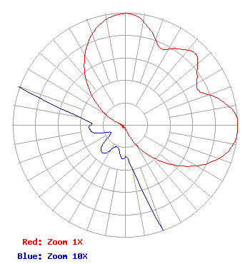 | ||||||||||||||||||
| Azimuth | Ratio | Azimuth | Ratio | Azimuth | Ratio | Azimuth | Ratio | ||||||||||||
| 5 | 0.981 | 15 | 0.874 | 25 | 0.753 | 35 | 0.826 | ||||||||||||
| 45 | 0.889 | 55 | 0.782 | 65 | 0.722 | 75 | 0.873 | ||||||||||||
| 85 | 0.989 | 95 | 1.000 | 105 | 0.941 | 115 | 0.812 | ||||||||||||
| 125 | 0.642 | 135 | 0.461 | 145 | 0.292 | 155 | 0.156 | ||||||||||||
| 165 | 0.063 | 175 | 0.031 | 185 | 0.030 | 195 | 0.022 | ||||||||||||
| 205 | 0.022 | 215 | 0.031 | 225 | 0.030 | 235 | 0.017 | ||||||||||||
| 245 | 0.015 | 255 | 0.028 | 265 | 0.032 | 275 | 0.032 | ||||||||||||
| 285 | 0.063 | 295 | 0.155 | 305 | 0.290 | 315 | 0.456 | ||||||||||||
| 325 | 0.631 | 335 | 0.791 | 345 | 0.911 | 355 | 0.979 | ||||||||||||
Structure Registration Number 1054173 Structure Type: GTOWER Registered To: Omega 2 Way Radio, LC Structure Address: 1/4 Mi Se Of Int Of 34th & Helium Amarillo, TX County Name: Randall County ASR Issued: 05/02/2016 Date Built: 05/01/1989 Site Elevation: 1150.9 m (3776 ft.) Structure Height: 122 m (400 ft.) Height Overall: 128 m (420 ft.) Overall Height AMSL: 1278.9 m (4196 ft.) FAA Determination: 04/20/2016 FAA Study #: 2016-ASW-3534-OE Paint & Light FAA Chapters: A2, H PRIOR STUDY 1989-ASW-750-OE 35-10-25.9 N 101-57-14.5 W (NAD 83) 35-10-25.7 N 101-57-12.8 W (Converted to NAD 27) |
295 Madison Avenue, 12th Floor New York, NY 10017 Phone: 954-606-5486 Corporation | Title: President Date: 06/20/2016 Application Certifier DTV AMERICA CORPORATION Dtv America Corporation 13450 W Sunrise Blvd Ste 164 Sunrise, FL 33323 Applicant RENEE ILHARDT Dtv America Corporation 13450 W. Sunrise Blvd, Suite #164 Sunrise, FL 33323 | |||||||||||||||||