
FCCInfo.com
A Service of Cavell, Mertz & Associates, Inc.
(855) FCC-INFO
|
|
DWTSD-CD from 06/14/2013 |
RF spectrum relinquished in the spectrum auction |
|
||||||||||||||||
|
|
Repacking Information: Channel 23 was relinquished in the spectrum auction Status: License Application Accepted: 08/28/2017 License Expires: 08/01/2015 File Number: -0000029524 FCC Website Links: LMS Facility Details This Application Other DWTSD-CD Applications Including Superseded Applications Mailing Address Correspondence for DWTSD-CD Correspondence related to application -0000029524 Service Contour - Open Street Map or USGS Map (51 dBu) Service Contour - KML / Google Earth (51 dBu) Public Inspection Files Rabbit Ears Info Search for DWTSD-CD Site Location: 40-02-19.7 N 75-14-12.8 W (NAD 83) Site Location: 40-02-19.3 N 75-14-14.2 W (Converted to NAD 27) ERP: 15 kW Polarization: Horizontally polarized R/C AGL: 318.4 m (1045 ft.) R/C AMSL: 394 m (1293 ft.) Emission Mask: Full Service Site Elevation: 75.6 m. (248 ft.) Height Overall*: 360.5 m (1183 ft.) (* As Filed In This Application, may differ from ASR Data, Below.) Directional Antenna - Antenna Make/Model: MICRO COMMUNICATIONS INC 955312 Antenna ID: 20058 Polarization: Horizontally polarized | ||||||||||||||||||
| Antenna Data for Antenna Id: 20058 DWTSD-CD DC File: -0000029524 MICRO COMMUNICATIONS INC - 955312 Service: DC Standard Pattern: Y Pattern and Field Values Include a 47° Clockwise Rotation | 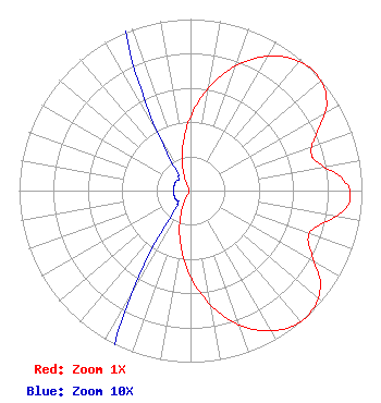 | ||||||||||||||||||
| Azimuth | Ratio | Azimuth | Ratio | Azimuth | Ratio | Azimuth | Ratio | ||||||||||||
| 7 | 0.556 | 17 | 0.729 | 27 | 0.872 | 37 | 0.967 | ||||||||||||
| 47 | 1.000 | 57 | 0.947 | 67 | 0.793 | 72 | 0.740 | ||||||||||||
| 77 | 0.756 | 87 | 0.902 | 92 | 0.933 | 97 | 0.902 | ||||||||||||
| 107 | 0.756 | 112 | 0.740 | 117 | 0.793 | 127 | 0.947 | ||||||||||||
| 137 | 1.000 | 147 | 0.967 | 157 | 0.872 | 167 | 0.729 | ||||||||||||
| 177 | 0.556 | 187 | 0.378 | 197 | 0.218 | 207 | 0.094 | ||||||||||||
| 217 | 0.021 | 227 | 0.010 | 237 | 0.010 | 247 | 0.010 | ||||||||||||
| 257 | 0.010 | 267 | 0.010 | 277 | 0.010 | 287 | 0.010 | ||||||||||||
| 297 | 0.010 | 307 | 0.010 | 317 | 0.010 | 327 | 0.021 | ||||||||||||
| 337 | 0.094 | 347 | 0.218 | 357 | 0.378 | ||||||||||||||
Structure Registration Number 1026755 Structure Type: GTOWER Registered To: American Towers LLC Structure Address: 216 Paoli Ave (010110) Philadelphia, PA County Name: Philadelphia County ASR Issued: 06/09/2015 Date Built: 08/01/2008 Site Elevation: 75.6 m (248 ft.) Structure Height: 338.9 m (1112 ft.) Height Overall: 360.5 m (1183 ft.) Overall Height AMSL: 436.1 m (1431 ft.) FAA Determination: 04/23/2015 FAA Study #: 2015-AEA-640-OE FAA Circular #: 70/7460-1K Paint & Light FAA Chapters: 3, 4, 5, 12 PRIOR STUDY 2013-AEA-5467-OE 40-02-19.7 N 75-14-12.8 W (NAD 83) 40-02-19.3 N 75-14-14.2 W (Converted to NAD 27) |
5670 Wilshire Blvd., Ste 1620 Los Angeles, CA 90036 Phone: 323-904-4090 Limited Liability Company | Title: Assistant Secretary Date: 08/28/2017 Application Certifier Local Media Tv Philadelphia Llc 5670 Wilshire Blvd., Ste 1620 Los Angeles, CA 90036 Applicant LAWRENCE ROGOW Local Media Tv Philadelphia Llc 5670 Wilshire Blvd., Suite 1620 Los Angeles, CA 90036 JOAN STEWART Wiley Rein Llp 1776 K Street Nw Washington, DC 20006 | |||||||||||||||||