
FCCInfo.com
A Service of Cavell, Mertz & Associates, Inc.
(855) FCC-INFO
|
|
KPPI-LD from 03/31/2005 KPPI-LD from 03/28/2005 KPPI-LD from 12/17/2004 KPPI-LD from 11/19/2001 |
|
|
||||||||||||||||
|
|
Status: License (Licensed And Silent) Application Accepted: 09/06/2017 License Expires: 02/01/2023 File Number: -0000029679 FCC Website Links: LMS Facility Details This Application Other KPPI-LD Applications Including Superseded Applications Mailing Address Correspondence for KPPI-LD Correspondence related to application -0000029679 Service Contour - Open Street Map or USGS Map (68 dBu) Service Contour - KML / Google Earth (68 dBu) Rabbit Ears Info Search for KPPI-LD Site Location: 15-11-11.1 N 145-44-39.6 E (NAD 83) ERP: 0.78 kW Polarization: Horizontally polarized R/C AGL: 24 m (79 ft.) R/C AMSL: 480 m (1575 ft.) Site Elevation: 456 m. (1496 ft.) Height Overall*: 42 m (138 ft.) (* As Filed In This Application, may differ from ASR Data, Below.) Directional Antenna - Antenna Make/Model: Jampro JHD-HV2 Antenna ID: 1002007 Polarization: Horizontally polarized
| ||||||||||||||||||
| Antenna Data for Antenna Id: 1002007 KPPI-LD TX File: -0000029679 Jampro - JHD-HV2 Service: TX Standard Pattern: N Pattern and Field Values Include a 22° Clockwise Rotation | 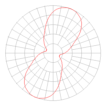 | ||||||||||||||||||
| Azimuth | Ratio | Azimuth | Ratio | Azimuth | Ratio | Azimuth | Ratio | ||||||||||||
| 2 | 0.888 | 12 | 0.970 | 22 | 1.000 | 32 | 0.970 | ||||||||||||
| 42 | 0.888 | 52 | 0.728 | 62 | 0.528 | 72 | 0.402 | ||||||||||||
| 82 | 0.310 | 92 | 0.233 | 102 | 0.163 | 112 | 0.146 | ||||||||||||
| 122 | 0.163 | 132 | 0.233 | 142 | 0.310 | 152 | 0.402 | ||||||||||||
| 162 | 0.528 | 172 | 0.728 | 182 | 0.888 | 192 | 0.970 | ||||||||||||
| 202 | 1.000 | 212 | 0.970 | 222 | 0.888 | 232 | 0.728 | ||||||||||||
| 242 | 0.528 | 252 | 0.402 | 262 | 0.310 | 272 | 0.233 | ||||||||||||
| 282 | 0.163 | 292 | 0.146 | 302 | 0.163 | 312 | 0.233 | ||||||||||||
| 322 | 0.310 | 332 | 0.402 | 342 | 0.528 | 352 | 0.728 | ||||||||||||
Structure Registration Number 1008506 Structure Type: GTOWER Registered To: Sorensen Pacific Broadcasting, Inc. Structure Address: Mt Tapochau Garapan, MP County Name: Saipan Municipality ASR Issued: 03/13/2018 Date Built: 03/27/2017 Site Elevation: 456 m (1496 ft.) Structure Height: 42 m (138 ft.) Height Overall: 42 m (138 ft.) Overall Height AMSL: 498 m (1634 ft.) FAA Determination: 02/15/2017 FAA Study #: 2016-AWP-12345-OE Paint & Light FAA Chapters: NONE 15-11-11.1 N 145-44-39.6 E (NAD 83) |
Saipan, MP 96950 Phone: 670-285-3322 Limited Liability Company | Title: Chairman Date: 09/06/2017 Application Certifier SORENSEN TELEVISION SYSTEMS, INC. Sorensen Television Systems, Inc. 962 Pale San Vitores Road Suite 116 Tumon, GU 96913 Applicant Gray Frierson Haertig Gray Frierson Haertig & Assoc. 4646 S.w. Council Crest Drive Portland, OR 97239 Engineering Counsel ALLAN G. MOSKOWITZ, MOSKOWITZ Allan G. Moskowitz, Esq. 10845 Tuckahoe Way N. Potomac, MD 20878 Esq. | |||||||||||||||||