
FCCInfo.com
A Service of Cavell, Mertz & Associates, Inc.
(855) FCC-INFO
|
|
K17MJ-D from 12/07/2006 K17MJ-D from 12/09/1991 |
|
|
||||||||||||||||
|
|
Status: License Application Accepted: 10/10/2017 License Expires: 08/01/2022 File Number: -0000032609 FCC Website Links: LMS Facility Details This Application Other K17MJ-D Applications Including Superseded Applications Mailing Address Correspondence for K17MJ-D Correspondence related to application -0000032609 Service Contour - Open Street Map or USGS Map (51 dBu) Service Contour - KML / Google Earth (51 dBu) Rabbit Ears Info Search for K17MJ-D Site Location: 29-26-29.9 N 98-30-22.8 W (NAD 83) Site Location: 29-26-29.1 N 98-30-21.7 W (Converted to NAD 27) ERP: 15 kW Polarization: Horizontally polarized Electrical Beam Tilt: 1.25 degrees R/C AGL: 148 m (486 ft.) R/C AMSL: 355.2 m (1165 ft.) Emission Mask: Stringent Site Elevation: 207.2 m. (680 ft.) Height Overall*: 152 m (499 ft.) (* As Filed In This Application, may differ from ASR Data, Below.) Directional Antenna - Antenna Make/Model: DIELECTRIC TLP-8B Antenna ID: 1002128 Polarization: Horizontally polarized | ||||||||||||||||||
| Antenna Data for Antenna Id: 1002128 K17MJ-D LD File: -0000032609 DIELECTRIC - TLP-8B Service: LD Standard Pattern: N | 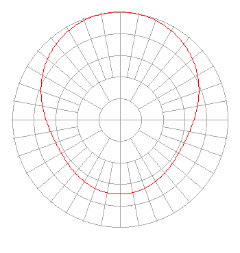 | ||||||||||||||||||
| Azimuth | Ratio | Azimuth | Ratio | Azimuth | Ratio | Azimuth | Ratio | ||||||||||||
| 0 | 1.000 | 10 | 0.995 | 20 | 0.979 | 30 | 0.953 | ||||||||||||
| 40 | 0.918 | 50 | 0.875 | 60 | 0.828 | 70 | 0.778 | ||||||||||||
| 80 | 0.729 | 90 | 0.686 | 100 | 0.653 | 110 | 0.633 | ||||||||||||
| 120 | 0.627 | 130 | 0.632 | 140 | 0.646 | 150 | 0.662 | ||||||||||||
| 160 | 0.678 | 170 | 0.689 | 180 | 0.692 | 190 | 0.689 | ||||||||||||
| 200 | 0.678 | 210 | 0.662 | 220 | 0.646 | 230 | 0.632 | ||||||||||||
| 240 | 0.627 | 250 | 0.633 | 260 | 0.653 | 270 | 0.686 | ||||||||||||
| 280 | 0.729 | 290 | 0.778 | 300 | 0.828 | 310 | 0.875 | ||||||||||||
| 320 | 0.918 | 330 | 0.953 | 340 | 0.979 | 350 | 0.995 | ||||||||||||
Structure Registration Number 1214327 Structure Type: GTOWER Registered To: American Towers LLC Structure Address: 1010 W. Laurel St. (atc Site # 282679) San Antonio, TX County Name: Bexar County ASR Issued: 05/24/2016 Date Built: 07/12/2001 Site Elevation: 207.2 m (680 ft.) Structure Height: 152 m (499 ft.) Height Overall: 152 m (499 ft.) Overall Height AMSL: 359.2 m (1178 ft.) FAA Determination: 03/16/2016 FAA Study #: 2016-ASW-2905-OE FAA Circular #: 70/7460-1L Paint & Light FAA Chapters: 4, 8, 12 PRIOR STUDY 2000-ASW-1251-OE 29-26-29.9 N 98-30-22.8 W (NAD 83) 29-26-29.1 N 98-30-21.7 W (Converted to NAD 27) |
295 Madison Avenue, 12th Floor New York, NY 10017 Phone: 954-606-5486 Corporation | Title: Member Date: 10/10/2017 Application Certifier MINTZ BROADCASTING Mintz Broadcasting 518 Peoples St Corpus Christi, TX 78401 Applicant LEE PENTZMAN Shainis & Peltzman 1800 M Street, N.w. Suite 240 Washington, DC 20036 JIMMY WILKEN Mako Communications 3406 Brawner Parkway Corpus Christi, TX 78411 ENGINEER | |||||||||||||||||