
FCCInfo.com
A Service of Cavell, Mertz & Associates, Inc.
(855) FCC-INFO
|
|
KFTR-DT from 01/01/2004 KFTR-DT from 11/01/2001 KFTR-DT from 12/29/1992 KFTR-DT from 01/05/1987 KFTR-DT from 11/28/1983 |
Virtual Channel 46 |
|
|||||||||||||||||||
|
|
Repacking Information: No changes Status: Construction Permit Application Accepted: 11/28/2017 KFTR-DT CP Expires: 12/03/2023 File Number: -0000035667 FCC Website Links: LMS Facility Details This Application Other KFTR-DT Applications Including Superseded Applications Mailing Address Correspondence for KFTR-DT Correspondence related to application -0000035667 Service Contour - Open Street Map or USGS Map (41 dBu) Service Contour - KML / Google Earth (41 dBu) Public Inspection Files History Cards for KFTR-DT Rabbit Ears Info Search for KFTR-DT Site Location: 34-13-36.1 N 118-04-02.3 W (NAD 83) Site Location: 34-13-36.1 N 118-03-59.1 W (Converted to NAD 27) ERP: 780 kW Polarization: Elliptically polarized HAAT: 949 m (3114 ft.) Electrical Beam Tilt: 1.5 degrees R/C AGL: 98 m (322 ft.) R/C AMSL: 1838.6 m (6032 ft.) Site Elevation: 1740.6 m. (5711 ft.) Height Overall*: 106.7 m (350 ft.) (* As Filed In This Application, may differ from ASR Data, Below.) Directional Antenna - Antenna Make/Model: Electronics Research Inc. ATW22HS6-ETC1-29H Antenna ID: 1002639 Polarization: Elliptically polarized | |||||||||||||||||||||
| Antenna Data for Antenna Id: 1002639 KFTR-DT DT File: -0000035667 Electronics Research Inc. - ATW22HS6-ETC1-29H Service: DT Standard Pattern: N | 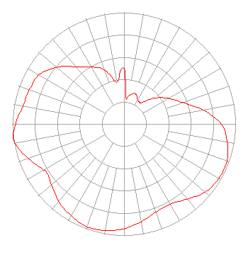 | |||||||||||||||||||||
| Azimuth | Ratio | Azimuth | Ratio | Azimuth | Ratio | Azimuth | Ratio | |||||||||||||||
| 0 | 0.500 | 4 | 0.240 | 10 | 0.260 | 20 | 0.290 | |||||||||||||||
| 30 | 0.250 | 35 | 0.240 | 40 | 0.250 | 50 | 0.360 | |||||||||||||||
| 60 | 0.460 | 70 | 0.560 | 80 | 0.720 | 90 | 0.870 | |||||||||||||||
| 100 | 0.940 | 110 | 0.980 | 120 | 0.980 | 130 | 0.950 | |||||||||||||||
| 140 | 0.880 | 150 | 0.830 | 160 | 0.840 | 170 | 0.890 | |||||||||||||||
| 180 | 0.940 | 190 | 0.970 | 200 | 0.980 | 210 | 0.950 | |||||||||||||||
| 220 | 0.910 | 230 | 0.850 | 237 | 0.820 | 240 | 0.830 | |||||||||||||||
| 250 | 0.910 | 260 | 0.990 | 263 | 1.000 | 270 | 0.970 | |||||||||||||||
| 280 | 0.920 | 290 | 0.900 | 300 | 0.880 | 310 | 0.790 | |||||||||||||||
| 320 | 0.670 | 330 | 0.590 | 340 | 0.520 | 350 | 0.380 | |||||||||||||||
Structure Registration Number 1232157 Structure Type: TOWER Registered To: Univision Television Group, Inc. Structure Address: Sited On Mt. Wilson (multiple Tall-tower Area) Pasadena, CA County Name: Los Angeles County ASR Issued: 10/18/2007 Date Built: 08/11/2002 Site Elevation: 1740.6 m (5711 ft.) Structure Height: 88.4 m (290 ft.) Height Overall: 106.7 m (350 ft.) Overall Height AMSL: 1847.3 m (6061 ft.) FAA Determination: 08/01/2001 FAA Study #: 01-AWP-2311-OE Paint & Light FAA Chapters: NONE PRIOR STUDY 99-AWP-2295-OE 34-13-36.1 N 118-04-02.3 W (NAD 83) 34-13-36.1 N 118-03-59.1 W (Converted to NAD 27) |
101 Constitution Avenue, Nw, Suite 800w Washington, DC 20001 Phone: 310-348-3600 Limited Liability Company | Title: Legal Counsel Date: 11/28/2017 Application Certifier UNIMAS LOS ANGELES LLC Unimas Los Angeles Llc 5999 Center Drive Los Angeles, CA 90045 Applicant Karl D Lahm, P.E. Univision Management Company 358 Pines Blvd. Lake Villa, IL 60046 Director, RF Systems Engineering MACE J. ROSENSTEIN, ESQ Covington & Burling Llp One Citycenter 850 Tenth Street Nw Washington, DC 20001 | ||||||||||||||||||||
| ||||||||||||||||||||||