
FCCInfo.com
A Service of Cavell, Mertz & Associates, Inc.
(855) FCC-INFO
|
|
DK34GL from 06/13/2002 |
|
|
||||||||||||||||
|
|
Status: License Application Accepted: 01/04/2018 License Expires: 10/01/2022 File Number: -0000037623 FCC Website Links: LMS Facility Details This Application Other DK34GL Applications Including Superseded Applications Mailing Address Correspondence for DK34GL Correspondence related to application -0000037623 Service Contour - Open Street Map or USGS Map (74 dBu) Service Contour - KML / Google Earth (74 dBu) Rabbit Ears Info Search for DK34GL Site Location: 34-57-20.2 N 104-40-55.0 W (NAD 83) Site Location: 34-57-20.0 N 104-40-53.0 W (Converted to NAD 27) ERP: 0.609 kW R/C AGL: 49 m (161 ft.) R/C AMSL: 1511.1 m (4958 ft.) Site Elevation: 1462.1 m. (4797 ft.) Height Overall*: 59.1 m (194 ft.) (* As Filed In This Application, may differ from ASR Data, Below.) Directional Antenna - Antenna Make/Model: Scala 4DR-8-2HW Antenna ID: 20751 | ||||||||||||||||||
| Antenna Data for Antenna Id: 20751 DK34GL TX File: -0000037623 Scala - 4DR-8-2HW Service: TX Standard Pattern: Y Pattern and Field Values Include a 180° Clockwise Rotation | 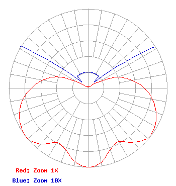 | ||||||||||||||||||
| Azimuth | Ratio | Azimuth | Ratio | Azimuth | Ratio | Azimuth | Ratio | ||||||||||||
| 0 | 0.020 | 10 | 0.020 | 20 | 0.020 | 30 | 0.020 | ||||||||||||
| 40 | 0.020 | 50 | 0.020 | 60 | 0.130 | 70 | 0.395 | ||||||||||||
| 80 | 0.560 | 90 | 0.710 | 100 | 0.825 | 110 | 0.915 | ||||||||||||
| 120 | 0.975 | 130 | 0.983 | 140 | 0.895 | 150 | 0.784 | ||||||||||||
| 160 | 0.827 | 170 | 0.955 | 180 | 1.000 | 190 | 0.945 | ||||||||||||
| 200 | 0.830 | 210 | 0.795 | 220 | 0.925 | 230 | 0.995 | ||||||||||||
| 240 | 0.975 | 250 | 0.920 | 260 | 0.835 | 270 | 0.715 | ||||||||||||
| 280 | 0.580 | 290 | 0.410 | 300 | 0.135 | 310 | 0.020 | ||||||||||||
| 320 | 0.020 | 330 | 0.020 | 340 | 0.020 | 350 | 0.020 | ||||||||||||
Structure Registration Number 1231696 Structure Type: TOWER Registered To: Regents of UNM & Board of Education of Abuquerque, NM (KNME-TV) Structure Address: 1.4 Km North Of Santa Rosa, New Mexico Santa Rosa, NM County Name: Guadalupe County ASR Issued: 01/08/2002 Date Built: 04/19/2002 Site Elevation: 1462.1 m (4797 ft.) Structure Height: 54.9 m (180 ft.) Height Overall: 59.1 m (194 ft.) Overall Height AMSL: 1521.2 m (4991 ft.) FAA Determination: 12/27/2001 FAA Study #: 01-ASW-7286-OE Paint & Light FAA Chapters: NONE Removed expiration date from determination. Scenario 1./jjs/case#635066 34-57-20.2 N 104-40-55.0 W (NAD 83) 34-57-20.0 N 104-40-53.0 W (Converted to NAD 27) |
9800 University Avenue Lubbock, TX 79423 Phone: 806-748-9300 Corporation | Title: President Date: 01/04/2018 Application Certifier Ramar Communications, Inc.. 9800 University Avenue Lubbock, TX 79423 Applicant Dennis P. Corbett Telecommunications Law Professionals Pllc 1025 Connecticut Avenue, Nw Suite 1011 Washington, DC 20036 Tee Thomas CE Ramar Communications, Inc.. 9800 University Avenue Lubbock, TX 79423 | |||||||||||||||||