
FCCInfo.com
A Service of Cavell, Mertz & Associates, Inc.
(855) FCC-INFO
|
|
K17JN-D from 08/25/2017 K17JN-D from 08/04/2017 K17JN-D from 08/03/2017 K17JN-D from 11/30/2016 K17JN-D from 11/29/2016 K17JN-D from 06/04/2016 K17JN-D from 02/25/2010 |
|
|
||||||||||||||||
|
|
Status: License Application Accepted: 06/08/2018 License Expires: 06/01/2022 File Number: -0000055105 FCC Website Links: LMS Facility Details This Application Other K17JN-D Applications Including Superseded Applications Mailing Address Correspondence for K17JN-D Correspondence related to application -0000055105 Service Contour - Open Street Map or USGS Map (51 dBu) Service Contour - KML / Google Earth (51 dBu) Rabbit Ears Info Search for K17JN-D Site Location: 36-24-28.4 N 97-59-55.5 W (NAD 83) Site Location: 36-24-28.3 N 97-59-54.3 W (Converted to NAD 27) ERP: 15 kW Polarization: Horizontally polarized R/C AGL: 90 m (295 ft.) R/C AMSL: 480.7 m (1577 ft.) Emission Mask: Full Service Site Elevation: 390.7 m. (1282 ft.) Height Overall*: 142 m (466 ft.) (* As Filed In This Application, may differ from ASR Data, Below.) Directional Antenna - Antenna Make/Model: Andrew AL8M Antenna ID: 1003852 Polarization: Horizontally polarized | ||||||||||||||||||
| Antenna Data for Antenna Id: 1003852 K17JN-D LD File: -0000055105 Andrew - AL8M Service: LD Standard Pattern: N Pattern and Field Values Include a 45° Clockwise Rotation | 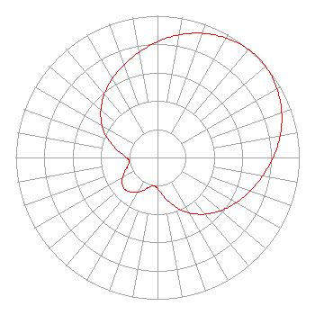 | ||||||||||||||||||
| Azimuth | Ratio | Azimuth | Ratio | Azimuth | Ratio | Azimuth | Ratio | ||||||||||||
| 5 | 0.848 | 15 | 0.907 | 25 | 0.954 | 35 | 0.988 | ||||||||||||
| 45 | 1.000 | 55 | 0.988 | 65 | 0.954 | 75 | 0.907 | ||||||||||||
| 85 | 0.848 | 95 | 0.784 | 105 | 0.723 | 115 | 0.667 | ||||||||||||
| 125 | 0.612 | 135 | 0.553 | 145 | 0.488 | 155 | 0.414 | ||||||||||||
| 165 | 0.327 | 175 | 0.246 | 185 | 0.203 | 195 | 0.215 | ||||||||||||
| 205 | 0.261 | 215 | 0.300 | 225 | 0.322 | 235 | 0.305 | ||||||||||||
| 245 | 0.261 | 255 | 0.215 | 265 | 0.203 | 275 | 0.246 | ||||||||||||
| 285 | 0.327 | 295 | 0.414 | 305 | 0.488 | 315 | 0.553 | ||||||||||||
| 325 | 0.612 | 335 | 0.667 | 345 | 0.723 | 355 | 0.784 | ||||||||||||
Structure Registration Number 1011491 Structure Type: GTOWER Registered To: Nolen Solutions, Inc. Structure Address: 9.65 Km W Jct Us 81 & 412 2 Km N Enid, OK County Name: Garfield County ASR Issued: 12/17/2020 Date Built: 01/01/1974 Site Elevation: 390.7 m (1282 ft.) Structure Height: 137.1 m (450 ft.) Height Overall: 142 m (466 ft.) Overall Height AMSL: 532.7 m (1748 ft.) FAA Determination: 12/09/2020 FAA Study #: 2020-ASW-16535-OE FAA Circular #: 70/7460-1M Paint & Light FAA Chapters: 4, 8, 15 PRIOR STUDY 2001-ASW-2910-OE 36-24-28.4 N 97-59-55.5 W (NAD 83) 36-24-28.3 N 97-59-54.3 W (Converted to NAD 27) |
11754 Us Hwy 77 Ardmore, OK 73601 Phone: 580-220-1033 Not-for-Profit | Title: President Date: 06/08/2018 Application Certifier CLARION BROADCASTING GROUP, INC. Clarion Broadcasting Group, Inc. 11754 Us Hwy 77 Ardmore, OK 73601 Applicant Kevin Fisher Smith And Fisher, Llc 4791 Wintergreen Court Woodbridge, VA 22192 Consulting Engineer DONALD MARTIN Donald E. Martin, P.c. Falls Church, VA 22041 ATTORNEY | |||||||||||||||||