
FCCInfo.com
A Service of Cavell, Mertz & Associates, Inc.
(855) FCC-INFO
|
|
WCTX from 04/01/1996 |
RF spectrum relinquished in the spectrum auction Virtual Channel 59 |
|
||||||||||||||||
|
|
WCTX is a channel sharing guest of WTNH, New Haven, Connecticut Repacking Information: Channel 39 was relinquished in the spectrum auction Status: License Application Accepted: 07/02/2018 License Expires: 04/01/2023 File Number: -0000055647 FCC Website Links: LMS Facility Details This Application Other WCTX Applications Including Superseded Applications Mailing Address Correspondence for WCTX Correspondence related to application -0000055647 Service Contour - Open Street Map or USGS Map (36 dBu) Service Contour - KML / Google Earth (36 dBu) Public Inspection Files Rabbit Ears Info Search for WCTX Site Location: 41-25-22.2 N 72-57-04.9 W (NAD 83) Site Location: 41-25-21.9 N 72-57-06.5 W (Converted to NAD 27) ERP: 20.5 kW Polarization: Horizontally polarized HAAT: 342 m (1122 ft.) R/C AGL: 244 m (801 ft.) R/C AMSL: 439.7 m (1443 ft.) Site Elevation: 195.7 m. (642 ft.) Height Overall*: 276.4 m (907 ft.) (* As Filed In This Application, may differ from ASR Data, Below.) Directional Antenna - Antenna Make/Model: DIELECTRIC THP-C4SP-2/8-1-R Antenna ID: 1003911 Polarization: Horizontally polarized | ||||||||||||||||||
| Antenna Data for Antenna Id: 1003911 WCTX DT File: -0000055647 DIELECTRIC - THP-C4SP-2/8-1-R Service: DT Standard Pattern: N | 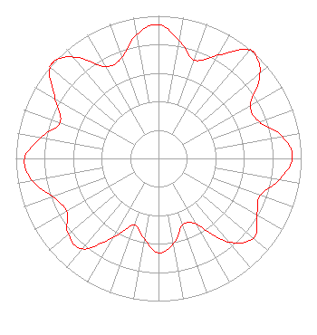 | ||||||||||||||||||
| Azimuth | Ratio | Azimuth | Ratio | Azimuth | Ratio | Azimuth | Ratio | ||||||||||||
| 0 | 0.938 | 10 | 0.839 | 20 | 0.734 | 30 | 0.838 | ||||||||||||
| 40 | 0.994 | 42 | 1.000 | 50 | 0.928 | 60 | 0.745 | ||||||||||||
| 70 | 0.751 | 80 | 0.883 | 90 | 0.939 | 100 | 0.859 | ||||||||||||
| 110 | 0.758 | 120 | 0.796 | 130 | 0.870 | 140 | 0.763 | ||||||||||||
| 150 | 0.535 | 160 | 0.496 | 170 | 0.606 | 180 | 0.662 | ||||||||||||
| 190 | 0.573 | 200 | 0.497 | 210 | 0.640 | 220 | 0.828 | ||||||||||||
| 230 | 0.827 | 240 | 0.744 | 250 | 0.787 | 260 | 0.900 | ||||||||||||
| 270 | 0.938 | 280 | 0.839 | 290 | 0.734 | 300 | 0.838 | ||||||||||||
| 310 | 0.994 | 312 | 1.000 | 313 | 1.000 | 320 | 0.928 | ||||||||||||
| 330 | 0.744 | 340 | 0.751 | 350 | 0.883 | ||||||||||||||
Structure Registration Number 1043980 Structure Type: TOWER Registered To: Nexstar Media Inc. Structure Address: End Of Talmadge Rd Hamden, CT County Name: New Haven County ASR Issued: 05/28/2021 Date Built: 06/27/2003 Site Elevation: 195.7 m (642 ft.) Structure Height: 234.7 m (770 ft.) Height Overall: 276.4 m (907 ft.) Overall Height AMSL: 472.1 m (1549 ft.) FAA Determination: 02/21/2003 FAA Study #: 2003-ANE-56-OE FAA Circular #: 70/7460-1K Paint & Light FAA Chapters: 3, 4, 5, 12 Removed expiration date from determination. Scenario 1./jjs/case#635066 41-25-22.2 N 72-57-04.9 W (NAD 83) 41-25-21.9 N 72-57-06.5 W (Converted to NAD 27) |
545 E. John Carpenter Freeway Suite 700 Irving, TX 75062 Phone: 972-373-8800 Corporation | Title: General Counsel Date: 07/02/2018 Application Certifier Nexstar Broadcasting, Inc. 545 E. John Carpenter Freeway Suite 700 Irving, TX 75062 Applicant Elizabeth Ryder Nexstar Broadcasting, Inc. 545 E. John Carpenter Freeway Suite 700 Irving, TX 75062 General Counsel | |||||||||||||||||