
FCCInfo.com
A Service of Cavell, Mertz & Associates, Inc.
(855) FCC-INFO
|
|
K16ML-D from 10/16/2018 K16ML-D from 11/16/2011 K16ML-D from 11/12/1985 |
|
|
||||||||||||||||
|
|
Status: License Application Accepted: 10/02/2018 License Expires: 02/01/2023 File Number: -0000060192 FCC Website Links: LMS Facility Details This Application Other K16ML-D Applications Including Superseded Applications Mailing Address Correspondence for K16ML-D Correspondence related to application -0000060192 Service Contour - Open Street Map or USGS Map (51 dBu) Service Contour - KML / Google Earth (51 dBu) Rabbit Ears Info Search for K16ML-D Site Location: 44-30-16.9 N 122-57-36.0 W (NAD 83) Site Location: 44-30-17.5 N 122-57-31.7 W (Converted to NAD 27) ERP: 2.2 kW Polarization: Horizontally polarized R/C AGL: 24 m (79 ft.) R/C AMSL: 455.6 m (1495 ft.) Emission Mask: Full Service Site Elevation: 431.6 m. (1416 ft.) Height Overall*: 65.8 m (216 ft.) (* As Filed In This Application, may differ from ASR Data, Below.) Directional Antenna - Antenna Make/Model: Kathrein 3X3 KBBU ARRAY Antenna ID: 98641 Polarization: Horizontally polarized
| ||||||||||||||||||
| Antenna Data for Antenna Id: 98641 K16ML-D LD File: -0000060192 Kathrein - 3X3 KBBU ARRAY Service: LD Standard Pattern: Y Pattern and Field Values Include a 240° Clockwise Rotation | 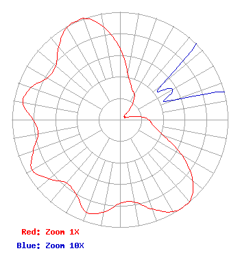 | ||||||||||||||||||
| Azimuth | Ratio | Azimuth | Ratio | Azimuth | Ratio | Azimuth | Ratio | ||||||||||||
| 0 | 0.659 | 10 | 0.428 | 20 | 0.313 | 30 | 0.267 | ||||||||||||
| 40 | 0.174 | 50 | 0.052 | 60 | 0.056 | 70 | 0.053 | ||||||||||||
| 80 | 0.174 | 90 | 0.267 | 100 | 0.313 | 110 | 0.428 | ||||||||||||
| 120 | 0.660 | 130 | 0.876 | 140 | 1.000 | 150 | 0.986 | ||||||||||||
| 160 | 0.884 | 170 | 0.777 | 180 | 0.777 | 190 | 0.873 | ||||||||||||
| 200 | 0.913 | 210 | 0.807 | 220 | 0.769 | 230 | 0.855 | ||||||||||||
| 240 | 0.938 | 250 | 0.855 | 260 | 0.769 | 270 | 0.806 | ||||||||||||
| 280 | 0.914 | 290 | 0.873 | 300 | 0.777 | 310 | 0.775 | ||||||||||||
| 320 | 0.884 | 330 | 0.986 | 340 | 1.000 | 350 | 0.875 | ||||||||||||
Structure Registration Number 1034282 Structure Type: LTOWER Registered To: American Towers LLC Structure Address: 35701 Rock Hill Road (peterson Butte #8222) Lebanon, OR County Name: Linn County ASR Issued: 07/03/2013 Date Built: 03/01/1993 Site Elevation: 431.6 m (1416 ft.) Structure Height: 61.3 m (201 ft.) Height Overall: 65.8 m (216 ft.) Overall Height AMSL: 497.4 m (1632 ft.) FAA Determination: 06/24/2013 FAA Study #: 2013-ANM-1357-OE FAA Circular #: 70/7460-1K Paint & Light FAA Chapters: 4, 6, 12 PRIOR STUDY 2006-ANM-3993-OE 44-30-16.9 N 122-57-36.0 W (NAD 83) 44-30-17.5 N 122-57-31.7 W (Converted to NAD 27) |
Tegna Inc. Tysons, VA 22102 Phone: 703-873-6606 Limited Liability Company | Title: Secretary Date: 10/02/2018 Application Certifier Sander Operating Co. Iii Llc D/b/a Kgw Television Tegna, Inc. 7950 Jones Branch Drive Mclean, VA 22107 Applicant Michael Beder, Esq Sander Operating Co. Iii Llc D/b/a Kgw Television 7950 Jones Branch Drive Mclean, VA 22107 Asosciate General Counsel William Meintel Meintel, Sgrignoli & Wallace, Llc Warrenton, VA 20187 Senior Partner | |||||||||||||||||