
FCCInfo.com
A Service of Cavell, Mertz & Associates, Inc.
(855) FCC-INFO
|
|
K30PD-D from 10/16/2018 K30PD-D from 07/19/2010 K30PD-D from 08/04/1992 |
|
|
|||||||||||||||||||||
|
|
Status: License Application Accepted: 10/01/2018 License Expires: 10/03/2022 File Number: -0000060011 FCC Website Links: LMS Facility Details This Application Other K30PD-D Applications Including Superseded Applications Mailing Address Correspondence for K30PD-D Correspondence related to application -0000060011 Service Contour - Open Street Map or USGS Map (51 dBu) Service Contour - KML / Google Earth (51 dBu) Rabbit Ears Info Search for K30PD-D Site Location: 37-03-34.6 N 112-31-12.2 W (NAD 83) Site Location: 37-03-34.7 N 112-31-09.5 W (Converted to NAD 27) ERP: 0.063 kW Polarization: Horizontally polarized R/C AGL: 15 m (49 ft.) R/C AMSL: 1774 m (5820 ft.) Emission Mask: Simple Site Elevation: 1759 m. (5771 ft.) Height Overall*: 19.5 m (64 ft.) (* As Filed In This Application, may differ from ASR Data, Below.) Directional Antenna - Antenna Make/Model: Scala 1X2KBBU Antenna ID: 20718 Polarization: Horizontally polarized
| |||||||||||||||||||||||
| Antenna Data for Antenna Id: 20718 K30PD-D LD File: -0000060011 Scala - 1X2KBBU Service: LD Standard Pattern: Y Pattern and Field Values Include a 180° Clockwise Rotation | 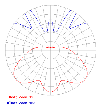 | |||||||||||||||||||||||
| Azimuth | Ratio | Azimuth | Ratio | Azimuth | Ratio | Azimuth | Ratio | |||||||||||||||||
| 0 | 0.069 | 10 | 0.043 | 20 | 0.051 | 30 | 0.116 | |||||||||||||||||
| 40 | 0.065 | 50 | 0.089 | 60 | 0.131 | 70 | 0.202 | |||||||||||||||||
| 80 | 0.316 | 90 | 0.432 | 100 | 0.570 | 110 | 0.738 | |||||||||||||||||
| 120 | 0.931 | 130 | 1.000 | 140 | 0.955 | 150 | 0.813 | |||||||||||||||||
| 160 | 0.717 | 170 | 0.846 | 180 | 0.931 | 190 | 0.846 | |||||||||||||||||
| 200 | 0.717 | 210 | 0.813 | 220 | 0.955 | 230 | 1.000 | |||||||||||||||||
| 240 | 0.931 | 250 | 0.738 | 260 | 0.570 | 270 | 0.432 | |||||||||||||||||
| 280 | 0.316 | 290 | 0.202 | 300 | 0.131 | 310 | 0.089 | |||||||||||||||||
| 320 | 0.065 | 330 | 0.116 | 340 | 0.051 | 350 | 0.043 | |||||||||||||||||
Structure Registration Number 1269722 Structure Type: TOWER Registered To: Western Kane County Special Service District Structure Address: Mountain North Northeast Of Kanab. 2.9 Miles From Kanab Municipal @ 15 Deg. Kanag, UT County Name: Kane County ASR Issued: 08/11/2009 Date Built: 08/05/2009 Site Elevation: 1759 m (5771 ft.) Structure Height: 19.5 m (64 ft.) Height Overall: 19.5 m (64 ft.) Overall Height AMSL: 1778.5 m (5835 ft.) FAA Determination: 08/03/2009 FAA Study #: 2009-ANM-1121-OE Paint & Light FAA Chapters: NONE 37-03-34.6 N 112-31-12.2 W (NAD 83) 37-03-34.7 N 112-31-09.5 W (Converted to NAD 27) |
101 Wasatch Drive Salt Lake City, UT 84112 Phone: 501-585-1601 Government Entity | Title: Technical Representative Date: 10/01/2018 Application Certifier UTAH STATE BOARD OF REGENTS Utah State Board Of Regents 101 Wasatch Drive Salt Lake City, UT 84112 Applicant MAURI Kent PARSONS Utah State Board Of Regents 371 South 460 East Monroe, UT 84754 Technical Representative PHILIP ALAN Titus Utah State Board Of Regents 101 Wasatch Drive Salt Lake City, UT 84112 Director of Engineering | ||||||||||||||||||||||