
FCCInfo.com
A Service of Cavell, Mertz & Associates, Inc.
(855) FCC-INFO
|
|
DK47GD from 05/07/1999 DK47GD from 03/04/1996 |
|
|
||||||||||||||||
|
|
Status: License Application Accepted: 01/09/2019 License Expires: 12/01/2022 File Number: -0000065886 FCC Website Links: LMS Facility Details This Application Other DK47GD Applications Including Superseded Applications Mailing Address Correspondence for DK47GD Correspondence related to application -0000065886 Service Contour - Open Street Map or USGS Map (74 dBu) Service Contour - KML / Google Earth (74 dBu) Rabbit Ears Info Search for DK47GD Site Location: 35-21-37.0 N 120-39-23.7 W (NAD 83) Site Location: 35-21-37.1 N 120-39-20.1 W (Converted to NAD 27) ERP: 27.1 kW Polarization: Horizontally polarized R/C AGL: 28.4 m (93 ft.) R/C AMSL: 776 m (2546 ft.) Site Elevation: 747.6 m. (2453 ft.) Height Overall*: 39 m (128 ft.) (* As Filed In This Application, may differ from ASR Data, Below.) Directional Antenna - Antenna Make/Model: Kathrein K72314 Antenna ID: 19753 Polarization: Horizontally polarized | ||||||||||||||||||
| Antenna Data for Antenna Id: 19753 DK47GD TX File: -0000065886 Kathrein - K72314 Service: TX Standard Pattern: Y | 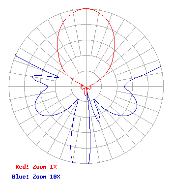 | ||||||||||||||||||
| Azimuth | Ratio | Azimuth | Ratio | Azimuth | Ratio | Azimuth | Ratio | ||||||||||||
| 0 | 1.000 | 10 | 0.960 | 20 | 0.870 | 30 | 0.730 | ||||||||||||
| 40 | 0.560 | 50 | 0.420 | 60 | 0.270 | 70 | 0.150 | ||||||||||||
| 80 | 0.070 | 90 | 0.050 | 100 | 0.060 | 110 | 0.070 | ||||||||||||
| 120 | 0.070 | 130 | 0.060 | 140 | 0.040 | 150 | 0.020 | ||||||||||||
| 160 | 0.050 | 170 | 0.010 | 180 | 0.120 | 190 | 0.100 | ||||||||||||
| 200 | 0.050 | 210 | 0.020 | 220 | 0.040 | 230 | 0.060 | ||||||||||||
| 240 | 0.070 | 250 | 0.070 | 260 | 0.060 | 270 | 0.050 | ||||||||||||
| 280 | 0.070 | 290 | 0.050 | 300 | 0.270 | 310 | 0.420 | ||||||||||||
| 320 | 0.560 | 330 | 0.730 | 340 | 0.870 | 350 | 0.960 | ||||||||||||
Structure Registration Number 1009393 Structure Type: TOWER Registered To: SBA Structures, LLC Structure Address: 2.75 Mi Sw Of Cuesta Electronics Site Los Padres Natl Forest Santa Margarita, CA County Name: San Luis Obispo County ASR Issued: 04/26/2013 Date Built: 10/15/1984 Site Elevation: 747.6 m (2453 ft.) Structure Height: 33.5 m (110 ft.) Height Overall: 39 m (128 ft.) Overall Height AMSL: 786.6 m (2581 ft.) FAA Determination: 10/09/2001 FAA Study #: 01-AWP-3890-OE Paint & Light FAA Chapters: NONE PRIOR STUDY 99-AWP-1064-OE 35-21-37.0 N 120-39-23.7 W (NAD 83) 35-21-37.1 N 120-39-20.1 W (Converted to NAD 27) |
9550 Firestone Boulevard Suite 105 Downey, CA 90241 Phone: 562-745-2355 Applicant | Title: President Date: 01/09/2019 Application Certifier KWHY-22 BROADCASTING, LLC Kwhy-22 Broadcasting, Llc 9550 Firestone Boulevard Suite 105 Downey, CA 90241 Applicant matt weitz Meruelo Group, Llc 9550 Firestone Blvd Ste 105 Downey, CA 90241 | |||||||||||||||||