
FCCInfo.com
A Service of Cavell, Mertz & Associates, Inc.
(855) FCC-INFO
|
|
W29EZ-D from 08/31/2012 W29EZ-D from 12/04/1998 |
|
|
||||||||||||||||
|
|
Status: License Application Accepted: 01/10/2019 License Expires: 06/01/2023 File Number: -0000066382 FCC Website Links: LMS Facility Details This Application Other W29EZ-D Applications Including Superseded Applications Mailing Address Correspondence for W29EZ-D Correspondence related to application -0000066382 Service Contour - Open Street Map or USGS Map (51 dBu) Service Contour - KML / Google Earth (51 dBu) Rabbit Ears Info Search for W29EZ-D Site Location: 42-01-55.0 N 76-47-01.0 W (NAD 83) Site Location: 42-01-54.7 N 76-47-02.2 W (Converted to NAD 27) ERP: 0.776 kW Polarization: Circularly polarized R/C AGL: 77 m (253 ft.) R/C AMSL: 615.6 m (2020 ft.) Emission Mask: Full Service Site Elevation: 538.6 m. (1767 ft.) Height Overall*: 97.5 m (320 ft.) (* As Filed In This Application, may differ from ASR Data, Below.) Directional Antenna - Antenna Make/Model: Jampro JA/LS-8_Elmira Antenna ID: 1004527 Polarization: Circularly polarized | ||||||||||||||||||
| Antenna Data for Antenna Id: 1004527 W29EZ-D LD File: -0000066382 Jampro - JA/LS-8_Elmira Service: LD Standard Pattern: N | 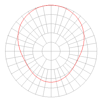 | ||||||||||||||||||
| Azimuth | Ratio | Azimuth | Ratio | Azimuth | Ratio | Azimuth | Ratio | ||||||||||||
| 0 | 1.000 | 10 | 0.994 | 20 | 0.978 | 30 | 0.951 | ||||||||||||
| 40 | 0.915 | 50 | 0.871 | 60 | 0.820 | 70 | 0.767 | ||||||||||||
| 80 | 0.715 | 90 | 0.668 | 100 | 0.631 | 110 | 0.609 | ||||||||||||
| 120 | 0.602 | 130 | 0.608 | 140 | 0.623 | 150 | 0.642 | ||||||||||||
| 160 | 0.659 | 170 | 0.672 | 180 | 0.676 | 190 | 0.672 | ||||||||||||
| 200 | 0.659 | 210 | 0.642 | 220 | 0.623 | 230 | 0.608 | ||||||||||||
| 240 | 0.602 | 250 | 0.609 | 260 | 0.631 | 270 | 0.668 | ||||||||||||
| 280 | 0.715 | 290 | 0.767 | 300 | 0.820 | 310 | 0.871 | ||||||||||||
| 320 | 0.915 | 330 | 0.951 | 340 | 0.978 | 350 | 0.994 | ||||||||||||
Structure Registration Number 1006946 Structure Type: GTOWER Registered To: T & K Communications Systems, Inc Structure Address: Comfort Hill Rd Elmira, NY County Name: Chemung County ASR Issued: 05/13/2022 Date Built: 07/01/1984 Site Elevation: 538.6 m (1767 ft.) Structure Height: 91.4 m (300 ft.) Height Overall: 97.5 m (320 ft.) Overall Height AMSL: 636.1 m (2087 ft.) FAA Determination: 03/21/2014 FAA Study #: 2013-AEA-4608-OE FAA Circular #: 70/7460-1K Paint & Light FAA Chapters: 4, 8, 12 Unterminated study at request of FCC./vn/case#HD0000002277002 42-01-55.0 N 76-47-01.0 W (NAD 83) 42-01-54.7 N 76-47-02.2 W (Converted to NAD 27) |
Po Box 220 West Frankfort, IL 62896 Phone: 618-627-4651 Not-for-Profit | Title: President Date: 01/10/2019 Application Certifier THREE ANGELS BROADCASTING NETWORK, INC. Three Angels Broadcasting Network, Inc. Po Box 220 West Frankfort, IL 62896 Applicant DANIEL N. PEEK 3abn Po Box 220 West Frankfort, IL 62896 ENGINEER MOSES PRIMO 3abn West Frankfort, IL 62896 DIRECTOR OF BROADCASTING OPERATIONS AND ENGINEERING | |||||||||||||||||