
FCCInfo.com
A Service of Cavell, Mertz & Associates, Inc.
(855) FCC-INFO
|
|
|
Post-repack Channel 17 Virtual Channel 16 |
|
|||||||||||||||||||
|
|
Repacking Information: Pre-Repack Channel: 46 Post-Repack Channel: 17 Post-Repack ERP: 95.4 kW Phase: 2 Completion Deadline: 4/12/2019 Upstream/Downstream Dependencies Other Linked Stations Find nearby TV Facilities Status: License Application Accepted: 04/12/2019 License Expires: 02/01/2022 File Number: -0000071604 FCC Website Links: LMS Facility Details This Application Other KSNF Applications Including Superseded Applications Mailing Address Correspondence for KSNF Correspondence related to application -0000071604 Service Contour - Open Street Map or USGS Map (41 dBu) Service Contour - KML / Google Earth (41 dBu) Public Inspection Files History Cards for KSNF Rabbit Ears Info Search for KSNF Site Location: 37-04-33.0 N 94-33-17.0 W (NAD 83) Site Location: 37-04-32.8 N 94-33-16.2 W (Converted to NAD 27) ERP: 525 kW Polarization: Elliptically polarized HAAT: 321.9 m (1056 ft.) Electrical Beam Tilt: 0.75 degrees R/C AGL: 297.9 m (977 ft.) R/C AMSL: 614.7 m (2017 ft.) Site Elevation: 316.8 m. (1039 ft.) Height Overall*: 310 m (1017 ft.) (* As Filed In This Application, may differ from ASR Data, Below.) Directional Antenna - Antenna Make/Model: Dielectric TUM25-04-16/64H-R-1-T Antenna ID: 1004829 Polarization: Elliptically polarized | |||||||||||||||||||||
| Antenna Data for Antenna Id: 1004829 KSNF DT File: -0000071604 Dielectric - TUM25-04-16/64H-R-1-T Service: DT Standard Pattern: N | 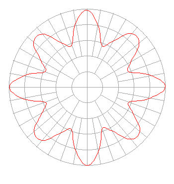 | |||||||||||||||||||||
| Azimuth | Ratio | Azimuth | Ratio | Azimuth | Ratio | Azimuth | Ratio | |||||||||||||||
| 0 | 0.980 | 10 | 0.800 | 20 | 0.560 | 30 | 0.680 | |||||||||||||||
| 40 | 0.890 | 50 | 0.870 | 60 | 0.650 | 70 | 0.570 | |||||||||||||||
| 80 | 0.840 | 90 | 1.000 | 100 | 0.820 | 110 | 0.570 | |||||||||||||||
| 120 | 0.680 | 130 | 0.880 | 140 | 0.870 | 150 | 0.650 | |||||||||||||||
| 160 | 0.570 | 170 | 0.840 | 180 | 1.000 | 190 | 0.830 | |||||||||||||||
| 200 | 0.580 | 210 | 0.680 | 220 | 0.890 | 230 | 0.880 | |||||||||||||||
| 240 | 0.660 | 250 | 0.570 | 260 | 0.840 | 270 | 0.990 | |||||||||||||||
| 280 | 0.820 | 290 | 0.570 | 300 | 0.680 | 310 | 0.890 | |||||||||||||||
| 320 | 0.880 | 330 | 0.650 | 340 | 0.570 | 350 | 0.830 | |||||||||||||||
Structure Registration Number 1002544 Structure Type: TOWER Registered To: Nexstar Media Inc. Structure Address: 1502 Cleveland Joplin, MO County Name: Jasper County ASR Issued: 05/28/2021 Date Built: 01/01/1978 Site Elevation: 316.8 m (1039 ft.) Structure Height: 289 m (948 ft.) Height Overall: 310 m (1017 ft.) Overall Height AMSL: 626.8 m (2056 ft.) FAA Determination: 09/26/1978 FAA Study #: 78-ACE-689-OE Paint & Light FAA Chapters: 1, 3, 7, 16, 21 RED LIGHTS/PAINT 37-04-33.0 N 94-33-17.0 W (NAD 83) 37-04-32.8 N 94-33-16.2 W (Converted to NAD 27) |
545 E. John Carpenter Freeway Suite 700 Irving, TX 75062 Phone: 972-373-8800 Corporation | Title: General Counsel Date: 04/12/2019 Application Certifier Nexstar Broadcasting, Inc. 545 E. John Carpenter Freeway Suite 700 Irving, TX 75062 Applicant William T Godfrey, Jr Kessler And Gehman Associates, Inc. Kessler And Gehman Associates, Inc. 507-d Nw 60th Street Gainesville, FL 32607 Consulting Engineers Elizabeth Ryder Nexstar Broadcasting, Inc. 545 E John Carpenter Freeway Suite 700 Irving, TX 75062 General Counsel | ||||||||||||||||||||
| ||||||||||||||||||||||