
FCCInfo.com
A Service of Cavell, Mertz & Associates, Inc.
(855) FCC-INFO
|
|
WRCX-LD from 07/17/2008 WRCX-LD from 10/15/2007 WRCX-LD from 07/18/2000 WRCX-LD from 12/01/1995 WRCX-LD from 09/28/1994 WRCX-LD from 08/24/1987 |
|
|
||||||||||||||||
|
|
Status: STA – Special Temporary Authority Application Accepted: 05/02/2019 STA Expires: 05/08/2019 File Number: -0000072325 FCC Website Links: LMS Facility Details This Application Other WRCX-LD Applications Including Superseded Applications Mailing Address Correspondence for WRCX-LD Correspondence related to application -0000072325 Service Contour - Open Street Map or USGS Map (74 dBu) Service Contour - KML / Google Earth (74 dBu) Rabbit Ears Info Search for WRCX-LD Site Location: 39-43-28.0 N 84-15-18.0 W (NAD 83) Site Location: 39-43-27.8 N 84-15-18.2 W (Converted to NAD 27) ERP: 34 kW R/C AGL: 280 m (919 ft.) R/C AMSL: 553.1 m (1815 ft.) Site Elevation: 273.1 m. (896 ft.) Height Overall*: 351.4 m (1153 ft.) (* As Filed In This Application, may differ from ASR Data, Below.) Directional Antenna - Antenna Make/Model: Jampro JA/LS-AB-24 Antenna ID: 19330 | ||||||||||||||||||
| Antenna Data for Antenna Id: 19330 WRCX-LD TX File: -0000072325 Jampro - JA/LS-AB-24 Service: TX Standard Pattern: Y Pattern and Field Values Include a 100° Clockwise Rotation | 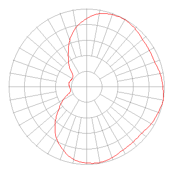 | ||||||||||||||||||
| Azimuth | Ratio | Azimuth | Ratio | Azimuth | Ratio | Azimuth | Ratio | ||||||||||||
| 0 | 0.870 | 10 | 0.950 | 20 | 0.980 | 30 | 0.990 | ||||||||||||
| 40 | 0.970 | 50 | 0.940 | 60 | 0.930 | 70 | 0.930 | ||||||||||||
| 80 | 0.960 | 90 | 0.980 | 100 | 1.000 | 110 | 0.980 | ||||||||||||
| 120 | 0.960 | 130 | 0.930 | 140 | 0.930 | 150 | 0.940 | ||||||||||||
| 160 | 0.970 | 170 | 0.990 | 180 | 0.980 | 190 | 0.950 | ||||||||||||
| 200 | 0.870 | 210 | 0.770 | 220 | 0.630 | 230 | 0.470 | ||||||||||||
| 240 | 0.350 | 250 | 0.230 | 260 | 0.210 | 270 | 0.220 | ||||||||||||
| 280 | 0.230 | 290 | 0.220 | 300 | 0.210 | 310 | 0.230 | ||||||||||||
| 320 | 0.350 | 330 | 0.470 | 340 | 0.630 | 350 | 0.770 | ||||||||||||
Structure Registration Number 1013716 Structure Type: TOWER Registered To: WRGT-TV Structure Address: 2045 S Gettysburg Rd Dayton, OH County Name: Montgomery County ASR Issued: 05/07/2002 Date Built: 08/15/1984 Site Elevation: 273.1 m (896 ft.) Structure Height: 335 m (1099 ft.) Height Overall: 351.4 m (1153 ft.) Overall Height AMSL: 624.5 m (2049 ft.) FAA Determination: 04/02/2002 FAA Study #: 01-agl-8063-oe FAA Circular #: Paint & Light FAA Chapters: A1, B, E, H Removed expiration date from determination. Scenario 1./jjs/case#635066 39-43-28.0 N 84-15-18.0 W (NAD 83) 39-43-27.8 N 84-15-18.2 W (Converted to NAD 27) |
708 West Hillcrest Avenue Dayton, OH 45406 Phone: 937-275-7677 Limited Liability Company | Title: President Date: 05/02/2019 Application Certifier ROSS COMMUNICATIONS, LTD. Ross Communications, Ltd. 708 West Hillcrest Avenue Dayton, OH 45406 Applicant TIMOTHY Z SAWYER T Z Sawyer Technical Consultants 2130 Hutchison Grove Court, Suite 100 Falls Church, VA 22043 Technical Consultant KATHLEEN VICTORY, ESQ. Fletcher Heald & Hildreth, Plc 1300 N. 17th Street 11th Floor Arlington, VA 22209 COUNSEL | |||||||||||||||||