
FCCInfo.com
A Service of Cavell, Mertz & Associates, Inc.
(855) FCC-INFO
|
|
|
RF spectrum relinquished in the spectrum auction Virtual Channel 35 |
|
||||||||||||||||
|
|
WWTO-TV is a channel sharing guest of WLPD-CD, Plano, Illinois Repacking Information: Channel 10 was relinquished in the spectrum auction Status: STA – Special Temporary Authority Application Accepted: 06/13/2019 STA Expires: 00/00/0000 File Number: -0000074718 FCC Website Links: LMS Facility Details This Application Other WWTO-TV Applications Including Superseded Applications Mailing Address Correspondence for WWTO-TV Correspondence related to application -0000074718 Service Contour - Open Street Map or USGS Map (41 dBu) Service Contour - KML / Google Earth (41 dBu) Public Inspection Files Rabbit Ears Info Search for WWTO-TV Site Location: 41-50-18.3 N 88-04-48.9 W (NAD 83) Site Location: 41-50-18.2 N 88-04-48.7 W (Converted to NAD 27) ERP: 15 kW Polarization: Horizontally polarized HAAT: 415 m (1362 ft.) Electrical Beam Tilt: 0.25 degrees R/C AGL: 78.8 m (259 ft.) R/C AMSL: 307.4 m (1009 ft.) Emission Mask: Full Service Site Elevation: 228.6 m. (750 ft.) Height Overall*: 91.5 m (300 ft.) (* As Filed In This Application, may differ from ASR Data, Below.) Directional Antenna - Antenna Make/Model: DIELECTRIC TUA-C3-4/12L Antenna ID: 111434 Polarization: Horizontally polarized | ||||||||||||||||||
| Antenna Data for Antenna Id: 111434 WWTO-TV DT File: -0000074718 DIELECTRIC - TUA-C3-4/12L Service: DT Standard Pattern: Y Pattern and Field Values Include a 180° Clockwise Rotation | 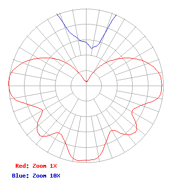 | ||||||||||||||||||
| Azimuth | Ratio | Azimuth | Ratio | Azimuth | Ratio | Azimuth | Ratio | ||||||||||||
| 0 | 0.056 | 10 | 0.050 | 20 | 0.073 | 30 | 0.204 | ||||||||||||
| 40 | 0.377 | 50 | 0.540 | 60 | 0.704 | 70 | 0.853 | ||||||||||||
| 80 | 0.954 | 90 | 0.978 | 100 | 0.942 | 110 | 0.756 | ||||||||||||
| 120 | 0.686 | 130 | 0.849 | 134 | 0.876 | 140 | 0.828 | ||||||||||||
| 150 | 0.672 | 160 | 0.770 | 170 | 0.940 | 180 | 0.969 | ||||||||||||
| 190 | 0.960 | 200 | 0.786 | 210 | 0.707 | 220 | 0.854 | ||||||||||||
| 224 | 0.876 | 230 | 0.820 | 240 | 0.652 | 250 | 0.752 | ||||||||||||
| 260 | 0.946 | 270 | 0.999 | 273 | 1.000 | 280 | 0.977 | ||||||||||||
| 290 | 0.865 | 300 | 0.710 | 310 | 0.545 | 320 | 0.371 | ||||||||||||
| 330 | 0.189 | 340 | 0.087 | 350 | 0.062 | ||||||||||||||
Structure Registration Number 1029952 Structure Type: LTOWER Registered To: College of DuPage, District 502 Structure Address: 22nd St & Lambert Rd Glen Ellyn, IL County Name: DuPage County ASR Issued: 10/02/2017 Date Built: 12/12/2013 Site Elevation: 228.6 m (750 ft.) Structure Height: 91.5 m (300 ft.) Height Overall: 91.5 m (300 ft.) Overall Height AMSL: 320.1 m (1050 ft.) FAA Determination: 03/14/2007 FAA Study #: 2007-AGL-1510-OE Paint & Light FAA Chapters: A1, H, 3, 11, 21, 23 PRIOR STUDY 1993-AGL-1283-OE 41-50-18.3 N 88-04-48.9 W (NAD 83) 41-50-18.2 N 88-04-48.7 W (Converted to NAD 27) |
13600 Heritage Parkway Suite 200 Fort Worth, TX 76177 Phone: 855-826-2255 Not-for-Profit | Title: Assistant Secretary Date: 06/13/2019 Application Certifier TRINITY BROADCASTING OF TEXAS, INC. Trinity Broadcasting Of Texas, Inc. 13600 Heritage Parkway Suite 200 Fort Worth, TX 76177 Applicant Kevin T. Fisher T. Fisher Smith & Fisher 4791 Wintergreen Court Woodbridge, VA 22192 Esq. Coby M. May M. May, Esq. Colby M. May, Esq., P.c. P. O. Box 15473 Washington, DC 20003 | |||||||||||||||||