
FCCInfo.com
A Service of Cavell, Mertz & Associates, Inc.
(855) FCC-INFO
|
|
K46KI-D from 01/28/1982 |
|
|
||||||||||||||||
|
|
Status: Construction Permit Application Accepted: 07/01/2019 K46KI-D CP Expires: 07/13/2021 File Number: -0000075178 FCC Website Links: LMS Facility Details This Application Other K46KI-D Applications Including Superseded Applications Mailing Address Correspondence for K46KI-D Correspondence related to application -0000075178 Service Contour - Open Street Map or USGS Map (51 dBu) Service Contour - KML / Google Earth (51 dBu) Rabbit Ears Info Search for K46KI-D Site Location: 39-18-37.3 N 106-56-55.0 W (NAD 83) Site Location: 39-18-37.4 N 106-56-52.8 W (Converted to NAD 27) ERP: 0.06 kW Polarization: Horizontally polarized R/C AGL: 9 m (30 ft.) R/C AMSL: 2691.8 m (8831 ft.) Emission Mask: Stringent Site Elevation: 2682.8 m. (8802 ft.) Height Overall*: 15.8 m (52 ft.) (* As Filed In This Application, may differ from ASR Data, Below.) Directional Antenna - Antenna Make/Model: Kathrein TWO K723147 @ 137, 227 DEG Antenna ID: 93084 Polarization: Horizontally polarized | ||||||||||||||||||
| Antenna Data for Antenna Id: 93084 K46KI-D LD File: -0000075178 Kathrein - TWO K723147 @ 137, 227 DEG Service: LD Standard Pattern: Y | 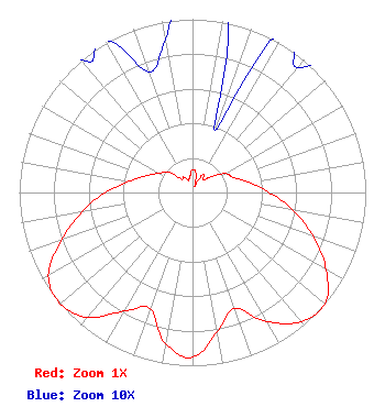 | ||||||||||||||||||
| Azimuth | Ratio | Azimuth | Ratio | Azimuth | Ratio | Azimuth | Ratio | ||||||||||||
| 0 | 0.132 | 10 | 0.114 | 20 | 0.038 | 30 | 0.118 | ||||||||||||
| 40 | 0.094 | 50 | 0.139 | 60 | 0.219 | 70 | 0.251 | ||||||||||||
| 80 | 0.333 | 90 | 0.444 | 100 | 0.591 | 110 | 0.742 | ||||||||||||
| 120 | 0.891 | 130 | 1.000 | 140 | 0.974 | 150 | 0.860 | ||||||||||||
| 160 | 0.712 | 170 | 0.815 | 180 | 0.951 | 190 | 0.888 | ||||||||||||
| 200 | 0.714 | 210 | 0.791 | 220 | 0.941 | 230 | 0.998 | ||||||||||||
| 240 | 0.961 | 250 | 0.805 | 260 | 0.651 | 270 | 0.503 | ||||||||||||
| 280 | 0.371 | 290 | 0.283 | 300 | 0.223 | 310 | 0.183 | ||||||||||||
| 320 | 0.101 | 330 | 0.103 | 340 | 0.074 | 350 | 0.090 | ||||||||||||
Structure Registration Number 1242304 Structure Type: TOWER Registered To: Pitkin County Translator Department Structure Address: Williams Hill Snowmass Village, CO County Name: Pitkin County ASR Issued: 12/30/2014 Date Built: 01/31/2008 Site Elevation: 2682.8 m (8802 ft.) Structure Height: 15.8 m (52 ft.) Height Overall: 15.8 m (52 ft.) Overall Height AMSL: 2698.6 m (8854 ft.) FAA Determination: 07/18/2008 FAA Study #: 2008-ANM-2244-OE Paint & Light FAA Chapters: NONE PRIOR STUDY 2002-ANM-403-OE 39-18-37.3 N 106-56-55.0 W (NAD 83) 39-18-37.4 N 106-56-52.8 W (Converted to NAD 27) |
351 Southside Dr. Basalt, CO 81621 Phone: 970-429-6114 Government Entity | Title: Communications Manager Date: 07/01/2019 Application Certifier PITKIN COUNTY TRANSLATOR DEPARTMENT Pitkin County Translator Department 351 Southside Dr. Basalt, CO 81621 Applicant Jim McDonald B. W. St. Clair 117 East Eleventh St. Loveland, CO 80537 Engineering Consultant | |||||||||||||||||