
FCCInfo.com
A Service of Cavell, Mertz & Associates, Inc.
(855) FCC-INFO
|
|
KBND-LD from 08/02/2019 KBND-LD from 01/26/2015 KBND-LD from 08/11/2005 KBND-LD from 10/17/2001 |
|
|
||||||||||||||||
|
|
Status: License Application Accepted: 07/17/2019 License Expires: 02/01/2023 File Number: -0000078155 FCC Website Links: LMS Facility Details This Application Other KBND-LD Applications Including Superseded Applications Mailing Address Correspondence for KBND-LD Correspondence related to application -0000078155 Service Contour - Open Street Map or USGS Map (51 dBu) Service Contour - KML / Google Earth (51 dBu) Rabbit Ears Info Search for KBND-LD Site Location: 44-04-38.2 N 121-20-00.7 W (NAD 83) Site Location: 44-04-38.8 N 121-19-56.6 W (Converted to NAD 27) ERP: 2.3 kW Polarization: Horizontally polarized R/C AGL: 53 m (174 ft.) R/C AMSL: 1335.6 m (4382 ft.) Emission Mask: Stringent Site Elevation: 1282.6 m. (4208 ft.) Height Overall*: 91.4 m (300 ft.) (* As Filed In This Application, may differ from ASR Data, Below.) Directional Antenna - Antenna Make/Model: Scala 2X2KBBU Antenna ID: 20727 Polarization: Horizontally polarized | ||||||||||||||||||
| Antenna Data for Antenna Id: 20727 KBND-LD LD File: -0000078155 Scala - 2X2KBBU Service: LD Standard Pattern: Y Pattern and Field Values Include a 120° Clockwise Rotation | 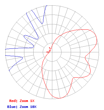 | ||||||||||||||||||
| Azimuth | Ratio | Azimuth | Ratio | Azimuth | Ratio | Azimuth | Ratio | ||||||||||||
| 0 | 0.131 | 10 | 0.202 | 20 | 0.316 | 30 | 0.432 | ||||||||||||
| 40 | 0.570 | 50 | 0.738 | 60 | 0.931 | 70 | 1.000 | ||||||||||||
| 80 | 0.955 | 90 | 0.813 | 100 | 0.717 | 110 | 0.846 | ||||||||||||
| 120 | 0.931 | 130 | 0.846 | 140 | 0.717 | 150 | 0.813 | ||||||||||||
| 160 | 0.955 | 170 | 1.000 | 180 | 0.931 | 190 | 0.738 | ||||||||||||
| 200 | 0.570 | 210 | 0.432 | 220 | 0.316 | 230 | 0.202 | ||||||||||||
| 240 | 0.131 | 250 | 0.089 | 260 | 0.065 | 270 | 0.116 | ||||||||||||
| 280 | 0.051 | 290 | 0.043 | 300 | 0.069 | 310 | 0.043 | ||||||||||||
| 320 | 0.051 | 330 | 0.116 | 340 | 0.065 | 350 | 0.089 | ||||||||||||
Structure Registration Number 1244492 Structure Type: TOWER Registered To: THE CHACKEL FAMILY, LLC Structure Address: Awbrey Butte Bend, OR County Name: Deschutes County ASR Issued: 07/26/2004 Date Built: 10/23/2004 Site Elevation: 1282.6 m (4208 ft.) Structure Height: 91.4 m (300 ft.) Height Overall: 91.4 m (300 ft.) Overall Height AMSL: 1374 m (4508 ft.) FAA Determination: 07/20/2004 FAA Study #: 2004-ANM-367-OE FAA Circular #: 70/7460-1K Paint & Light FAA Chapters: 3, 4, 5, 12 Removed expiration date from determination. Scenario 1./jjs/case#635066 44-04-38.2 N 121-20-00.7 W (NAD 83) 44-04-38.8 N 121-19-56.6 W (Converted to NAD 27) |
63088 Northeast 18th Street Bend, OR 97701 Phone: 541-382-5263 Corporation | Title: President Date: 07/17/2019 Application Certifier COMBINED COMMUNICATIONS, INC. Combined Communications, Inc. 63088 Northeast 18th Street Bend, OR 97701 Applicant Rick 0lson Combined Communications 63088 Northeast 18th Street Bend, OR 97701 ENGINEER Matthew H. Mccormick Fletcher, Heald & Hildreth, Plc 1300 N. 17th Street 11th Floor Arlington, VA 22209 Legal Counsel ERIK C SWANSON, PE Hatfield & Dawson 9500 Greenwood Ave N Seattle, WA 98103 CONSULTING ENGINEER | |||||||||||||||||