
FCCInfo.com
A Service of Cavell, Mertz & Associates, Inc.
(855) FCC-INFO
|
|
K51EF-D from 08/05/2019 K51EF-D from 01/03/2011 K51EF-D from 08/25/1992 |
|
|
||||||||||||||||
|
|
Status: License Application Accepted: 08/01/2019 License Expires: 10/03/2022 File Number: -0000079605 FCC Website Links: LMS Facility Details This Application Other K33QB-D Applications Including Superseded Applications Mailing Address Correspondence for K33QB-D Correspondence related to application -0000079605 Service Contour - Open Street Map or USGS Map (51 dBu) Service Contour - KML / Google Earth (51 dBu) Rabbit Ears Info Search for K33QB-D Site Location: 48-31-51.2 N 116-49-01.4 W (NAD 83) Site Location: 48-31-51.5 N 116-48-57.7 W (Converted to NAD 27) ERP: 0.1 kW Polarization: Horizontally polarized R/C AGL: 14 m (46 ft.) R/C AMSL: 976.6 m (3204 ft.) Emission Mask: Stringent Site Elevation: 962.6 m. (3158 ft.) Height Overall*: 15.2 m (50 ft.) (* As Filed In This Application, may differ from ASR Data, Below.) Directional Antenna - Antenna Make/Model: Scala 4DR-4-2HW Antenna ID: 20741 Polarization: Horizontally polarized
| ||||||||||||||||||
| Antenna Data for Antenna Id: 20741 K33QB-D LD File: -0000079605 Scala - 4DR-4-2HW Service: LD Standard Pattern: Y Pattern and Field Values Include a 270° Clockwise Rotation | 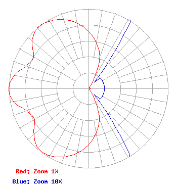 | ||||||||||||||||||
| Azimuth | Ratio | Azimuth | Ratio | Azimuth | Ratio | Azimuth | Ratio | ||||||||||||
| 0 | 0.715 | 10 | 0.580 | 20 | 0.410 | 30 | 0.135 | ||||||||||||
| 40 | 0.020 | 50 | 0.020 | 60 | 0.020 | 70 | 0.020 | ||||||||||||
| 80 | 0.020 | 90 | 0.020 | 100 | 0.020 | 110 | 0.020 | ||||||||||||
| 120 | 0.020 | 130 | 0.020 | 140 | 0.020 | 150 | 0.130 | ||||||||||||
| 160 | 0.395 | 170 | 0.560 | 180 | 0.710 | 190 | 0.825 | ||||||||||||
| 200 | 0.915 | 210 | 0.975 | 220 | 0.983 | 230 | 0.895 | ||||||||||||
| 240 | 0.784 | 250 | 0.827 | 260 | 0.955 | 270 | 1.000 | ||||||||||||
| 280 | 0.945 | 290 | 0.830 | 300 | 0.795 | 310 | 0.925 | ||||||||||||
| 320 | 0.995 | 330 | 0.975 | 340 | 0.920 | 350 | 0.835 | ||||||||||||
Structure Registration Number 1293841 Structure Type: GTOWER Registered To: Priest Lake Translator District Structure Address: Kinner Point Communications Site, Ne Of Coolin, Id Coolin, ID County Name: Bonner County ASR Issued: 11/14/2014 Date Built: 01/01/1991 Site Elevation: 962.6 m (3158 ft.) Structure Height: 15.2 m (50 ft.) Height Overall: 15.2 m (50 ft.) Overall Height AMSL: 977.8 m (3208 ft.) FAA Determination: 08/08/2014 FAA Study #: 2014-ANM-1913-OE Paint & Light FAA Chapters: NONE PRIOR STUDY 2007-ANM-2019-OE 48-31-51.2 N 116-49-01.4 W (NAD 83) 48-31-51.5 N 116-48-57.7 W (Converted to NAD 27) |
Coolin, ID 83821 Phone: 208-443-2492 Government Entity | Title: Acting Chairman Date: 08/01/2019 Application Certifier PRIEST LAKE TRANSLATOR DISTRICT Priest Lake Translator District Coolin, ID 83821 Applicant LARRY AYER Priest Lake Translator District Po Box 12 Nordman, ID 83848 MEMBER, DISTRICT BOARD OF TRUSTEES Jim McDonald B. W. St. Clair 117 East Eleventh St. Loveland, CO 80537 Engineering Consultant | |||||||||||||||||