
FCCInfo.com
A Service of Cavell, Mertz & Associates, Inc.
(855) FCC-INFO
|
|
KRLJ-LD from 05/17/2011 |
|
|
||||||||||||||||
|
|
Status: License Application Accepted: 08/05/2019 License Expires: 02/01/2022 File Number: -0000079995 FCC Website Links: LMS Facility Details This Application Other KRLJ-LD Applications Including Superseded Applications Mailing Address Correspondence for KRLJ-LD Correspondence related to application -0000079995 Service Contour - Open Street Map or USGS Map (51 dBu) Service Contour - KML / Google Earth (51 dBu) Rabbit Ears Info Search for KRLJ-LD Site Location: 37-11-30.1 N 94-41-19.0 W (NAD 83) Site Location: 37-11-29.9 N 94-41-18.2 W (Converted to NAD 27) ERP: 15 kW Polarization: Horizontally polarized R/C AGL: 95 m (312 ft.) R/C AMSL: 362.3 m (1189 ft.) Emission Mask: Full Service Site Elevation: 267.3 m. (877 ft.) Height Overall*: 106.1 m (348 ft.) (* As Filed In This Application, may differ from ASR Data, Below.) Directional Antenna - Antenna Make/Model: Alive ATC-BCSE12M-U1 Antenna ID: Polarization: Horizontally polarized | ||||||||||||||||||
| Antenna Data for Antenna Id: KRLJ-LD LD File: -0000079995 Alive - ATC-BCSE12M-U1 Service: LD Standard Pattern: N Pattern and Field Values Include a 170.0° Clockwise Rotation | 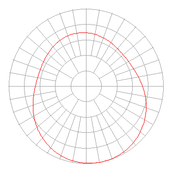 | ||||||||||||||||||
| Azimuth | Ratio | Azimuth | Ratio | Azimuth | Ratio | Azimuth | Ratio | ||||||||||||
| 0 | 0.689 | 10 | 0.678 | 20 | 0.662 | 30 | 0.646 | ||||||||||||
| 40 | 0.632 | 50 | 0.627 | 60 | 0.633 | 70 | 0.653 | ||||||||||||
| 80 | 0.686 | 90 | 0.729 | 100 | 0.778 | 110 | 0.828 | ||||||||||||
| 120 | 0.875 | 130 | 0.918 | 140 | 0.953 | 150 | 0.979 | ||||||||||||
| 160 | 0.995 | 170 | 1.000 | 180 | 0.995 | 190 | 0.979 | ||||||||||||
| 200 | 0.953 | 210 | 0.918 | 220 | 0.875 | 230 | 0.828 | ||||||||||||
| 240 | 0.778 | 250 | 0.729 | 260 | 0.686 | 270 | 0.653 | ||||||||||||
| 280 | 0.633 | 290 | 0.627 | 300 | 0.632 | 310 | 0.646 | ||||||||||||
| 320 | 0.662 | 330 | 0.678 | 340 | 0.689 | 350 | 0.692 | ||||||||||||
Structure Registration Number 1217160 Structure Type: TOWER Registered To: American Towers LLC Structure Address: 7822 Ne Bethlehem Rd (lawton Ks # 35630) Galena, KS County Name: Cherokee County ASR Issued: 01/15/2013 Date Built: 09/11/2000 Site Elevation: 267.3 m (877 ft.) Structure Height: 103.6 m (340 ft.) Height Overall: 106.1 m (348 ft.) Overall Height AMSL: 373.4 m (1225 ft.) FAA Determination: 07/14/2005 FAA Study #: 2005-ACE-1844-OE Paint & Light FAA Chapters: A1, H, 3, 11, 21, 23 Continue As Is OM&L = A MED-DUAL SYSTEM 37-11-30.1 N 94-41-19.0 W (NAD 83) 37-11-29.9 N 94-41-18.2 W (Converted to NAD 27) |
295 Madison Avenue, 12th Floor New York, NY 10017 Phone: 954-606-5486 Corporation | Title: Chief Operating Officer Date: 08/05/2019 Application Certifier Dtv America Corporation 450 Park Avenue 30th Floor New York, NY 10022 Applicant Paul A. Cicelski, Esq Lerman Senter Pllc 2001 L St. Nw Suite 400 Washington, DC 20036 Kurt Hanson Hc2 Broadcasting Holdings, Inc. 450 Park Ave. 30th Fl New York, NY 10022 Chief Technology Officer Rebecca Hanson Hc2 Broadcasting Holdings, Inc. 450 Park Ave. 30th Fl New York, NY 10022 EVP and GENERAL COUNSEL RENEE ILHARDT Dtv America Corporation 450 Park Ave 30th Fl New York, NY 10022 | |||||||||||||||||