FCCInfo.com
A Service of Cavell, Mertz & Associates, Inc.
(855) FCC-INFO
|
|
KWHS-LP from 11/04/1996 K51CE from 08/26/1991 HF0308RZ from ??? |
|
|
||||||||||||||||
|
|
Status: LIC Application Accepted: 09/16/2019 License Expires: 04/01/2030 File Number: 0000081492 FCC Website Links: LMS Facility Details This Application Other KWHS-LD Applications Including Superseded Applications Service Contour - Open Street Map or USGS Map (48 dBu) Service Contour - KML / Google Earth (48 dBu) Rabbit Ears Info Search for KWHS-LD Site Location: 38-44-41.9 N 104-51-39.4 W (NAD 83) Site Location: 38-44-41.9 N 104-51-37.5 W (Converted to NAD 27) ERP: 3 kW Polarization: Horizontally polarized R/C AGL: 42.1 m (138 ft.) R/C AMSL: 2903 m (9524 ft.) Emission Mask: Full Service Site Elevation: 2860.9 m. (9386 ft.) Height Overall*: 90.5 m (297 ft.) (* As Filed In This Application, may differ from ASR Data, Below.) Directional Antenna - Antenna Make/Model: DIELECTRIC TLS-V4 Antenna ID: 1005556 Polarization: Horizontally polarized | ||||||||||||||||||
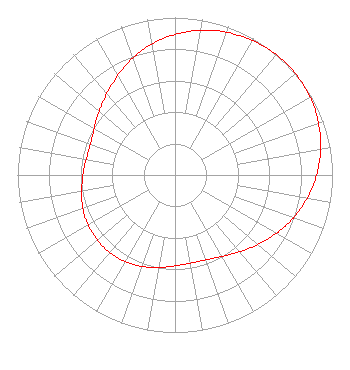
| Antenna Data for Antenna Id: 1005556 KWHS-LD LD File: -0000081492 DIELECTRIC - TLS-V4 Service: LD Standard Pattern: N Pattern and Field Values Include a 45° Clockwise Rotation |  | ||||||||||||||||||
| Azimuth | Ratio | Azimuth | Ratio | Azimuth | Ratio | Azimuth | Ratio | ||||||||||||
| 5 | 0.914 | 15 | 0.951 | 25 | 0.975 | 35 | 0.993 | ||||||||||||
| 45 | 1.000 | 55 | 0.996 | 65 | 0.981 | 75 | 0.955 | ||||||||||||
| 85 | 0.920 | 95 | 0.876 | 105 | 0.826 | 115 | 0.771 | ||||||||||||
| 125 | 0.714 | 135 | 0.661 | 145 | 0.615 | 155 | 0.583 | ||||||||||||
| 165 | 0.569 | 175 | 0.571 | 185 | 0.586 | 195 | 0.607 | ||||||||||||
| 205 | 0.627 | 215 | 0.640 | 225 | 0.645 | 235 | 0.641 | ||||||||||||
| 245 | 0.631 | 255 | 0.613 | 265 | 0.592 | 275 | 0.579 | ||||||||||||
| 285 | 0.570 | 295 | 0.579 | 305 | 0.610 | 315 | 0.650 | ||||||||||||
| 325 | 0.699 | 335 | 0.759 | 345 | 0.817 | 355 | 0.869 | ||||||||||||
Structure Registration Number 1257453 Structure Type: TOWER Registered To: CHEYENNE PROPAGATION Structure Address: Cheyenne Mountain Colorado Springs, CO County Name: El Paso County ASR Issued: 06/04/2012 Date Built: 07/02/2008 Site Elevation: 2860.9 m (9386 ft.) Structure Height: 76.2 m (250 ft.) Height Overall: 90.5 m (297 ft.) Overall Height AMSL: 2951.4 m (9683 ft.) FAA Determination: 01/25/2007 FAA Study #: 2006-ANM-3575-OE FAA Circular #: 70/7460-1K Paint & Light FAA Chapters: 4, 8, 12 Removed expiration date from determination. Scenario 1./jjs/case#635066 38-44-41.9 N 104-51-39.4 W (NAD 83) 38-44-41.9 N 104-51-37.5 W (Converted to NAD 27) |
PO Box 6922 Clearwater, FL 33758 Phone: 727-535-5622 Not-for-Profit | Title: President Date: 09/16/2019 Application Certifier Christian Televsion Corporation, Inc. Christian Televsion Corporation, Inc. PO Box 6922 Clearwater, FL 33758 Applicant Joseph C Chautin, III Hardy, Carey, Chautin & Balkin, L.L.P. 1080 West Causeway Approach Mandeville, LA 70471 William Jeffrey Reynolds Du Treil, Lundin & Rackley, Inc. 3135 Southgate Circle Sarasota, FL 34239 Technical Consultant | |||||||||||||||||