
FCCInfo.com
A Service of Cavell, Mertz & Associates, Inc.
(855) FCC-INFO
|
|
WCWG from 08/28/2000 WCWG from 03/14/1996 WCWG from 05/03/1983 |
RF spectrum relinquished in the spectrum auction Virtual Channel 20 |  |
|
|||||||||||||||
|
|
WCWG is a channel sharing guest of WXII-TV, Winston-salem, North Carolina Repacking Information: Channel 19 was relinquished in the spectrum auction Status: License Application Accepted: 09/11/2019 License Expires: 12/01/2020 File Number: -0000081214 FCC Website Links: LMS Facility Details This Application Other WCWG Applications Including Superseded Applications Mailing Address Correspondence for WCWG Correspondence related to application -0000081214 Service Contour - Open Street Map or USGS Map (41 dBu) Service Contour - KML / Google Earth (41 dBu) Public Inspection Files Rabbit Ears Info Search for WCWG Site Location: 36-22-30.6 N 80-22-25.2 W (NAD 83) Site Location: 36-22-30.1 N 80-22-26.0 W (Converted to NAD 27) ERP: 1000 kW Polarization: Horizontally polarized HAAT: 571.9 m (1876 ft.) Electrical Beam Tilt: 1 degree R/C AGL: 160 m (525 ft.) R/C AMSL: 891.5 m (2925 ft.) Site Elevation: 731.5 m. (2400 ft.) Height Overall*: 177.7 m (583 ft.) (* As Filed In This Application, may differ from ASR Data, Below.) Directional Antenna - Antenna Make/Model: DIELECTRIC TFU-30DSC-R C135 Antenna ID: 1005513 Polarization: Horizontally polarized | ||||||||||||||||||
| Antenna Data for Antenna Id: 1005513 WCWG DT File: -0000081214 DIELECTRIC - TFU-30DSC-R C135 Service: DT Standard Pattern: N | 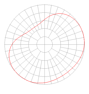 | ||||||||||||||||||
| Azimuth | Ratio | Azimuth | Ratio | Azimuth | Ratio | Azimuth | Ratio | ||||||||||||
| 0 | 0.622 | 10 | 0.716 | 20 | 0.809 | 30 | 0.886 | ||||||||||||
| 40 | 0.940 | 50 | 0.973 | 60 | 0.991 | 70 | 0.999 | ||||||||||||
| 76 | 1.000 | 80 | 0.999 | 90 | 0.993 | 100 | 0.978 | ||||||||||||
| 110 | 0.956 | 120 | 0.932 | 130 | 0.912 | 140 | 0.900 | ||||||||||||
| 150 | 0.900 | 160 | 0.912 | 170 | 0.932 | 180 | 0.956 | ||||||||||||
| 190 | 0.978 | 200 | 0.993 | 210 | 0.999 | 214 | 1.000 | ||||||||||||
| 220 | 0.999 | 230 | 0.991 | 240 | 0.973 | 250 | 0.940 | ||||||||||||
| 260 | 0.886 | 270 | 0.809 | 280 | 0.716 | 290 | 0.622 | ||||||||||||
| 300 | 0.549 | 310 | 0.511 | 320 | 0.498 | 330 | 0.498 | ||||||||||||
| 340 | 0.511 | 350 | 0.549 | ||||||||||||||||
Structure Registration Number 1008241 Structure Type: GTOWER Registered To: Hearst Properties Inc. Structure Address: Atop Sauratown Mtn End Of Sauratown Mtn Rd Pilot Mountain, NC County Name: Stokes County ASR Issued: 07/12/2018 Date Built: 07/11/2018 Site Elevation: 731.5 m (2400 ft.) Structure Height: 176.6 m (579 ft.) Height Overall: 177.7 m (583 ft.) Overall Height AMSL: 909.2 m (2983 ft.) FAA Determination: 05/07/2018 FAA Study #: 2018-ASO-3058-OE FAA Circular #: 70/7460-1L Paint & Light FAA Chapters: 3, 4, 5, 12 PRIOR STUDY 1996-ASO-5346-OE 36-22-30.6 N 80-22-25.2 W (NAD 83) 36-22-30.1 N 80-22-26.0 W (Converted to NAD 27) |
P.o. Box 1800 Raleigh, NC 27602 Phone: 919-839-0300 Limited Liability Company | Application Certifier Hearst Properties Inc Hearst Properties Inc Po Box 1800 Raleign, NC 27602 Applicant Coe W Ramsey Brooks, Pierce Et Al. 150 Fayetteville Street Suite 1700 Raleigh, NC 27601 | |||||||||||||||||