
FCCInfo.com
A Service of Cavell, Mertz & Associates, Inc.
(855) FCC-INFO
|
|
K33QC-D from 05/17/2011 |
|
|
|||||||||||||||||||||||||
|
|
Status: License Application Accepted: 09/23/2019 License Expires: 10/03/2022 File Number: -0000081916 FCC Website Links: LMS Facility Details This Application Other K33QC-D Applications Including Superseded Applications Mailing Address Correspondence for K33QC-D Correspondence related to application -0000081916 Service Contour - Open Street Map or USGS Map (51 dBu) Service Contour - KML / Google Earth (51 dBu) Rabbit Ears Info Search for K33QC-D Site Location: 35-40-51.0 N 109-03-10.6 W (NAD 83) Site Location: 35-40-50.9 N 109-03-08.3 W (Converted to NAD 27) ERP: 2.52 kW Polarization: Horizontally polarized Electrical Beam Tilt: 1.75 degrees R/C AGL: 20.7 m (68 ft.) R/C AMSL: 2122.3 m (6963 ft.) Emission Mask: Stringent Site Elevation: 2101.6 m. (6895 ft.) Height Overall*: 23.2 m (76 ft.) (* As Filed In This Application, may differ from ASR Data, Below.) Directional Antenna - Antenna Make/Model: Andrew AL8 Antenna ID: 16352 Polarization: Horizontally polarized
| |||||||||||||||||||||||||||
| Antenna Data for Antenna Id: 16352 K33QC-D LD File: -0000081916 Andrew - AL8 Service: LD Standard Pattern: Y | 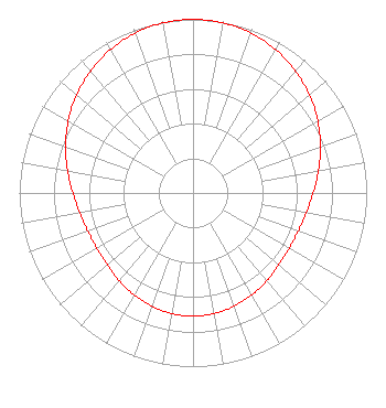 | |||||||||||||||||||||||||||
| Azimuth | Ratio | Azimuth | Ratio | Azimuth | Ratio | Azimuth | Ratio | |||||||||||||||||||||
| 0 | 1.000 | 10 | 0.995 | 20 | 0.979 | 30 | 0.953 | |||||||||||||||||||||
| 40 | 0.918 | 50 | 0.876 | 60 | 0.829 | 70 | 0.780 | |||||||||||||||||||||
| 80 | 0.733 | 90 | 0.692 | 100 | 0.662 | 110 | 0.644 | |||||||||||||||||||||
| 120 | 0.639 | 130 | 0.646 | 140 | 0.661 | 150 | 0.678 | |||||||||||||||||||||
| 160 | 0.694 | 170 | 0.705 | 180 | 0.709 | 190 | 0.705 | |||||||||||||||||||||
| 200 | 0.694 | 210 | 0.678 | 220 | 0.661 | 230 | 0.646 | |||||||||||||||||||||
| 240 | 0.639 | 250 | 0.644 | 260 | 0.662 | 270 | 0.692 | |||||||||||||||||||||
| 280 | 0.733 | 290 | 0.780 | 300 | 0.829 | 310 | 0.876 | |||||||||||||||||||||
| 320 | 0.918 | 330 | 0.953 | 340 | 0.979 | 350 | 0.995 | |||||||||||||||||||||
Structure Registration Number 1265075 Structure Type: TOWER Registered To: Navajo Nation Structure Address: 4611 Tribal Hill Road Window Rock, AZ County Name: Apache County ASR Issued: 04/23/2012 Date Built: 03/30/2012 Site Elevation: 2101.6 m (6895 ft.) Structure Height: 18.2 m (60 ft.) Height Overall: 23.2 m (76 ft.) Overall Height AMSL: 2124.8 m (6971 ft.) FAA Determination: 04/20/2012 FAA Study #: 2012-AWP-2641-OE Paint & Light FAA Chapters: NONE PRIOR STUDY 2011-AWP-8029-OE 35-40-51.0 N 109-03-10.6 W (NAD 83) 35-40-50.9 N 109-03-08.3 W (Converted to NAD 27) |
#w008-262 -tribal Hill Drive Window Rock, AZ 86515 Phone: 928-871-7826 Government Entity | Title: Program Manager Date: 09/23/2019 Application Certifier THE NAVAJO NATION The Navajo Nation #w008-262 -tribal Hill Drive Window Rock, AZ 86515 Applicant Edsel Pete Navajo Nation #w008-262 -tribal Hill Drive Window Rock, AZ 86515 Program Manager I Dennis Wallace Meintel, Sgrignoli, & Wallace, Llc 1282 Smallwood Drive Suite 372 Waldorf, MD 20603 Technical Consultant | ||||||||||||||||||||||||||
| ||||||||||||||||||||||||||||