
FCCInfo.com
A Service of Cavell, Mertz & Associates, Inc.
(855) FCC-INFO
|
|
W25FH-D from 05/17/2011 |
|
|
||||||||||||||||
|
|
Status: License Application Accepted: 11/08/2019 License Expires: 08/02/2021 File Number: -0000088484 FCC Website Links: LMS Facility Details This Application Other W25FH-D Applications Including Superseded Applications Mailing Address Correspondence for W25FH-D Correspondence related to application -0000088484 Service Contour - Open Street Map or USGS Map (51 dBu) Service Contour - KML / Google Earth (51 dBu) Rabbit Ears Info Search for W25FH-D Site Location: 41-05-56.9 N 85-08-42.0 W (NAD 83) Site Location: 41-05-56.7 N 85-08-42.1 W (Converted to NAD 27) ERP: 15 kW Polarization: Horizontally polarized Electrical Beam Tilt: .75 degrees R/C AGL: 103.6 m (340 ft.) R/C AMSL: 337.1 m (1106 ft.) Emission Mask: Full Service Site Elevation: 233.5 m. (766 ft.) Height Overall*: 128.3 m (421 ft.) (* As Filed In This Application, may differ from ASR Data, Below.) Directional Antenna - Antenna Make/Model: Electronics Research Inc. ETU2U1-HSP2C-32 Antenna ID: Polarization: Horizontally polarized | ||||||||||||||||||
| Antenna Data for Antenna Id: W25FH-D LD File: -0000088484 Electronics Research Inc. - ETU2U1-HSP2C-32 Service: LD Standard Pattern: N Pattern and Field Values Include a 37.0° Clockwise Rotation | 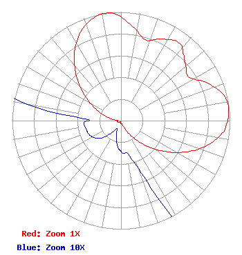 | ||||||||||||||||||
| Azimuth | Ratio | Azimuth | Ratio | Azimuth | Ratio | Azimuth | Ratio | ||||||||||||
| 7 | 0.876 | 17 | 0.777 | 27 | 0.844 | 37 | 0.893 | ||||||||||||
| 45 | 0.824 | 47 | 0.798 | 57 | 0.740 | 67 | 0.872 | ||||||||||||
| 77 | 0.980 | 87 | 0.991 | 93 | 0.966 | 97 | 0.934 | ||||||||||||
| 107 | 0.810 | 117 | 0.642 | 127 | 0.462 | 137 | 0.294 | ||||||||||||
| 147 | 0.159 | 157 | 0.062 | 167 | 0.033 | 177 | 0.030 | ||||||||||||
| 183 | 0.027 | 187 | 0.024 | 197 | 0.015 | 207 | 0.008 | ||||||||||||
| 217 | 0.014 | 227 | 0.023 | 237 | 0.029 | 247 | 0.032 | ||||||||||||
| 257 | 0.033 | 267 | 0.034 | 272 | 0.031 | 277 | 0.065 | ||||||||||||
| 287 | 0.159 | 297 | 0.286 | 307 | 0.442 | 317 | 0.614 | ||||||||||||
| 327 | 0.780 | 337 | 0.912 | 347 | 0.988 | 352 | 1.000 | ||||||||||||
| 357 | 0.981 | ||||||||||||||||||
Structure Registration Number 1028214 Structure Type: GTOWER Registered To: American Towers LLC Structure Address: 2602 Cass Street (fort Wayne -cass St. #090136) Fort Wayne, IN County Name: Allen County ASR Issued: 01/11/2023 Date Built: 05/17/2005 Site Elevation: 233.5 m (766 ft.) Structure Height: 123.4 m (405 ft.) Height Overall: 128.3 m (421 ft.) Overall Height AMSL: 361.8 m (1187 ft.) FAA Determination: 01/03/2023 FAA Study #: 2022-AGL-4782-OE FAA Circular #: 70/7460-1K Paint & Light FAA Chapters: 4, 8, 12 PRIOR STUDY 2012-AGL-5804-OE 41-05-56.9 N 85-08-42.0 W (NAD 83) 41-05-56.7 N 85-08-42.1 W (Converted to NAD 27) |
295 Madison Avenue, 12th Floor New York, NY 10017 Phone: 954-606-5486 Corporation | Title: Chief Operating Officer Date: 11/08/2019 Application Certifier Dtv America Corporation 450 Park Avenue 30th Floor New York, NY 10022 Applicant KURT HANSON Hc2 Broadcasting Holdings, Inc. 450 Park Ave 30th Fl New York, NY 10022 CHIEF TECHNOLOGY OFFICER REBECCA HANSON Hc2 Broadcasting Holdings, Inc. 450 Park Ave 30th Fl New York, NY 10022 EVP and General Counsel RENEE ILHARDT Hc2 Broadcasting Holdings, Inc. 450 Park Ave 30th Fl New York, NY 10022 | |||||||||||||||||