
FCCInfo.com
A Service of Cavell, Mertz & Associates, Inc.
(855) FCC-INFO
|
|
KISA-LD from 11/07/2005 KISA-LD from 04/08/2005 KISA-LD from 01/22/1992 |
|
|
||||||||||||||||
|
|
Status: License Application Accepted: 01/28/2020 License Expires: 08/01/2022 File Number: -0000101032 FCC Website Links: LMS Facility Details This Application Other KISA-LD Applications Including Superseded Applications Mailing Address Correspondence for KISA-LD Correspondence related to application -0000101032 Service Contour - Open Street Map or USGS Map (51 dBu) Service Contour - KML / Google Earth (51 dBu) Rabbit Ears Info Search for KISA-LD Site Location: 29-26-29.9 N 98-30-22.8 W (NAD 83) Site Location: 29-26-29.1 N 98-30-21.7 W (Converted to NAD 27) ERP: 15 kW Polarization: Horizontally polarized R/C AGL: 120 m (394 ft.) R/C AMSL: 327.2 m (1073 ft.) Emission Mask: Full Service Site Elevation: 207.2 m. (680 ft.) Height Overall*: 152 m (499 ft.) (* As Filed In This Application, may differ from ASR Data, Below.) Directional Antenna - Antenna Make/Model: Kathrein 2x1 75010210 Antenna ID: Polarization: Horizontally polarized | ||||||||||||||||||
| Antenna Data for Antenna Id: KISA-LD LD File: -0000101032 Kathrein - 2x1 75010210 Service: LD Standard Pattern: N Pattern and Field Values Include a 200.0° Clockwise Rotation | 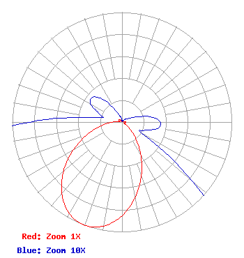 | ||||||||||||||||||
| Azimuth | Ratio | Azimuth | Ratio | Azimuth | Ratio | Azimuth | Ratio | ||||||||||||
| 0 | 0.001 | 10 | 0.001 | 20 | 0.002 | 30 | 0.001 | ||||||||||||
| 40 | 0.001 | 50 | 0.004 | 60 | 0.006 | 70 | 0.013 | ||||||||||||
| 80 | 0.027 | 90 | 0.035 | 100 | 0.033 | 110 | 0.022 | ||||||||||||
| 120 | 0.023 | 130 | 0.084 | 140 | 0.188 | 150 | 0.339 | ||||||||||||
| 160 | 0.516 | 170 | 0.696 | 180 | 0.852 | 190 | 0.962 | ||||||||||||
| 200 | 1.000 | 210 | 0.962 | 220 | 0.852 | 230 | 0.696 | ||||||||||||
| 240 | 0.516 | 250 | 0.339 | 260 | 0.188 | 270 | 0.084 | ||||||||||||
| 280 | 0.023 | 290 | 0.022 | 300 | 0.033 | 310 | 0.035 | ||||||||||||
| 320 | 0.027 | 330 | 0.013 | 340 | 0.006 | 350 | 0.004 | ||||||||||||
Structure Registration Number 1214327 Structure Type: GTOWER Registered To: American Towers LLC Structure Address: 1010 W. Laurel St. (atc Site # 282679) San Antonio, TX County Name: Bexar County ASR Issued: 05/24/2016 Date Built: 07/12/2001 Site Elevation: 207.2 m (680 ft.) Structure Height: 152 m (499 ft.) Height Overall: 152 m (499 ft.) Overall Height AMSL: 359.2 m (1178 ft.) FAA Determination: 03/16/2016 FAA Study #: 2016-ASW-2905-OE FAA Circular #: 70/7460-1L Paint & Light FAA Chapters: 4, 8, 12 PRIOR STUDY 2000-ASW-1251-OE 29-26-29.9 N 98-30-22.8 W (NAD 83) 29-26-29.1 N 98-30-21.7 W (Converted to NAD 27) |
295 Madison Avenue, 12th Floor New York, NY 10017 Phone: 954-606-5486 Corporation | Title: Chief Operating Officer Date: 01/28/2020 Application Certifier HC2 LPTV HOLDINGS, INC. Hc2 Lptv Holdings, Inc. 450 Park Avenue 30th Floor New York, NY 10022 Applicant PAUL CICELSKI Lerman Senter Pllc 2001 L Street, Nw, Suite 400 Washington Dc, DC 20036 KURT HANSON Hc2 Lptv Holdings, Inc. 450 Park Avenue 30th Floor New York, NY 10022 CHIEF TECHNICAL OFFICER REBECCA HANSON Hc2 Lptv Holdings, Inc. 450 Park Avenue 30th Floor New York, NY 10022 EVP AND GENERAL COUNSEL RENEE ILHARDT Hc2 Lptv Holdings, Inc. 450 Park Avenue 30th Floor New York, NY 10022 | |||||||||||||||||