
FCCInfo.com
A Service of Cavell, Mertz & Associates, Inc.
(855) FCC-INFO
|
|
WDWW-LD from 12/12/2013 WDWW-LD from 09/25/2013 WDWW-LD from 03/02/2004 WDWW-LD from 02/19/2004 |
|
|
||||||||||||||||
|
|
Status: License Application Accepted: 02/06/2020 License Expires: 04/01/2021 File Number: -0000105503 FCC Website Links: LMS Facility Details This Application Other WDWW-LD Applications Including Superseded Applications Mailing Address Correspondence for WDWW-LD Correspondence related to application -0000105503 Service Contour - Open Street Map or USGS Map (51 dBu) Service Contour - KML / Google Earth (51 dBu) Rabbit Ears Info Search for WDWW-LD Site Location: 33-48-26.4 N 84-20-21.5 W (NAD 83) Site Location: 33-48-26.0 N 84-20-21.8 W (Converted to NAD 27) ERP: 8 kW Polarization: Circularly polarized Electrical Beam Tilt: 1.0 degree R/C AGL: 283.5 m (930 ft.) R/C AMSL: 547.8 m (1797 ft.) Emission Mask: Full Service Site Elevation: 264.3 m. (867 ft.) Height Overall*: 360.3 m (1182 ft.) (* As Filed In This Application, may differ from ASR Data, Below.) Directional Antenna - Antenna Make/Model: Kathrein ATC-BCC512C150B-V3-28 Antenna ID: Polarization: Circularly polarized | ||||||||||||||||||
| Antenna Data for Antenna Id: WDWW-LD LD File: -0000105503 Kathrein - ATC-BCC512C150B-V3-28 Service: LD Standard Pattern: N Pattern and Field Values Include a 140.0° Clockwise Rotation | 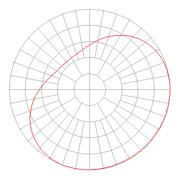 | ||||||||||||||||||
| Azimuth | Ratio | Azimuth | Ratio | Azimuth | Ratio | Azimuth | Ratio | ||||||||||||
| 0 | 0.551 | 10 | 0.619 | 20 | 0.697 | 30 | 0.777 | ||||||||||||
| 40 | 0.849 | 50 | 0.909 | 60 | 0.953 | 70 | 0.981 | ||||||||||||
| 80 | 0.995 | 90 | 1.000 | 100 | 0.999 | 110 | 0.995 | ||||||||||||
| 120 | 0.992 | 130 | 0.990 | 140 | 0.990 | 150 | 0.990 | ||||||||||||
| 160 | 0.992 | 170 | 0.995 | 180 | 0.999 | 190 | 1.000 | ||||||||||||
| 200 | 0.995 | 210 | 0.981 | 220 | 0.953 | 230 | 0.909 | ||||||||||||
| 240 | 0.849 | 250 | 0.777 | 260 | 0.697 | 270 | 0.619 | ||||||||||||
| 280 | 0.551 | 290 | 0.500 | 300 | 0.467 | 310 | 0.451 | ||||||||||||
| 320 | 0.446 | 330 | 0.451 | 340 | 0.467 | 350 | 0.500 | ||||||||||||
Structure Registration Number 1223132 Structure Type: GTOWER Registered To: American Towers LLC Structure Address: 1800 Briarcliff Road Ne (#282650) Atlanta, GA County Name: DeKalb County ASR Issued: 07/11/2023 Date Built: 03/27/2002 Site Elevation: 264.3 m (867 ft.) Structure Height: 321.9 m (1056 ft.) Height Overall: 360.3 m (1182 ft.) Overall Height AMSL: 624.6 m (2049 ft.) FAA Determination: 11/02/2021 FAA Study #: 2021-ASO-36490-OE FAA Circular #: 70/7460-1M Paint & Light FAA Chapters: 4, 9, 15 33-48-26.4 N 84-20-21.5 W (NAD 83) 33-48-26.0 N 84-20-21.8 W (Converted to NAD 27) |
295 Madison Avenue, 12th Floor New York, NY 10017 Phone: 954-606-5486 Corporation | Title: Chief Operating Officer Date: 02/06/2020 Application Certifier Dtv America Corporation 450 Park Avenue 30th Floor New York, NY 10022 Applicant PAUL CICELSKI Lerman Senter P Llc 2001 L Street, Nw, Suite 400 Washington Dc, DC 20036 REBECCA HANSON Hc2 Broadcasting 450 Park Avenue, 30th Floor New York, NY 10022 EVP AND GENERAL COUNSEL KURT HANSON Hc2 Broadcasting Holdings, Inc 450 Park Avenue 30th Floor New York, NY 10022 CHIEF TECHNICAL OFFICER RENEE ILHARDT Dtv America Corporation 450 Park Avenue, 30th Floor New York, NY 10022 | |||||||||||||||||