
FCCInfo.com
A Service of Cavell, Mertz & Associates, Inc.
(855) FCC-INFO
|
|
K25LG-D from 01/28/2000 K25LG-D from 01/26/1995 K25LG-D from 12/05/1991 |
|
|
||||||||||||||||
|
|
Status: License Application Accepted: 03/11/2020 License Expires: 08/01/2022 File Number: -0000107602 FCC Website Links: LMS Facility Details This Application Other K25LG-D Applications Including Superseded Applications Mailing Address Correspondence for K25LG-D Correspondence related to application -0000107602 Service Contour - Open Street Map or USGS Map (51 dBu) Service Contour - KML / Google Earth (51 dBu) Rabbit Ears Info Search for K25LG-D Site Location: 32-03-41.0 N 95-18-51.0 W (NAD 83) Site Location: 32-03-40.4 N 95-18-50.2 W (Converted to NAD 27) ERP: 15 kW Polarization: Horizontally polarized R/C AGL: 200 m (656 ft.) R/C AMSL: 377 m (1237 ft.) Emission Mask: Full Service Site Elevation: 177 m. (581 ft.) Height Overall*: 447 m (1467 ft.) (* As Filed In This Application, may differ from ASR Data, Below.) Directional Antenna - Antenna Make/Model: Jampro JUHD 10X2 Antenna ID: 1006540 Polarization: Horizontally polarized | ||||||||||||||||||
| Antenna Data for Antenna Id: 1006540 K25LG-D LD File: -0000107602 Jampro - JUHD 10X2 Service: LD Standard Pattern: N | 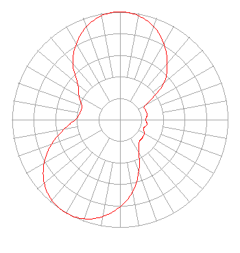 | ||||||||||||||||||
| Azimuth | Ratio | Azimuth | Ratio | Azimuth | Ratio | Azimuth | Ratio | ||||||||||||
| 0 | 1.000 | 10 | 0.980 | 20 | 0.917 | 30 | 0.813 | ||||||||||||
| 40 | 0.680 | 50 | 0.530 | 60 | 0.275 | 70 | 0.253 | ||||||||||||
| 80 | 0.256 | 90 | 0.236 | 100 | 0.255 | 110 | 0.233 | ||||||||||||
| 120 | 0.260 | 130 | 0.267 | 140 | 0.276 | 150 | 0.349 | ||||||||||||
| 160 | 0.509 | 170 | 0.679 | 180 | 0.809 | 190 | 0.914 | ||||||||||||
| 200 | 0.979 | 210 | 1.000 | 220 | 0.979 | 230 | 0.916 | ||||||||||||
| 240 | 0.812 | 250 | 0.679 | 260 | 0.529 | 270 | 0.413 | ||||||||||||
| 280 | 0.374 | 290 | 0.377 | 300 | 0.438 | 310 | 0.510 | ||||||||||||
| 320 | 0.680 | 330 | 0.810 | 340 | 0.915 | 350 | 0.980 | ||||||||||||
Structure Registration Number 1047886 Structure Type: TOWER Registered To: Pinnacle Towers LLC Structure Address: 1.8 Mi W Of Mount Selmand And S Of Hwy 855 Mount Selman, TX County Name: Cherokee County ASR Issued: 05/06/2016 Date Built: 12/01/1986 Site Elevation: 177 m (581 ft.) Structure Height: 445 m (1460 ft.) Height Overall: 447 m (1467 ft.) Overall Height AMSL: 624 m (2047 ft.) FAA Determination: 07/07/1986 FAA Study #: 86-ASW-0755-OE FAA Circular #: 70/7460-1G Paint & Light FAA Chapters: 4, 6, 9 24 HOUR HIGH INTENSITY WHITE LIGHTS 32-03-41.0 N 95-18-51.0 W (NAD 83) 32-03-40.4 N 95-18-50.2 W (Converted to NAD 27) |
Po Box 220 West Frankfort, IL 62896 Phone: 618-627-4651 Not-for-Profit | Title: President Date: 03/11/2020 Application Certifier THREE ANGELS BROADCASTING NETWORK, INC. Three Angels Broadcasting Network, Inc. Po Box 220 West Frankfort, IL 62896 Applicant DANIEL N. PEEK 3abn Po Box 220 West Frankfort, IL 62896 ENGINEER MOSES PRIMO 3abn West Frankfort, IL 62896 DIRECTOR OF BROADCASTING OPERATIONS AND ENGINEERING | |||||||||||||||||