
FCCInfo.com
A Service of Cavell, Mertz & Associates, Inc.
(855) FCC-INFO
|
|
KHMF-LD from 01/08/2018 KHMF-LD from 12/28/2005 KHMF-LD from 06/26/1995 |
|
|
|||||||||||||||||
|
|
Status: License Application Accepted: 06/25/2020 License Expires: 06/01/2021 File Number: -0000116534 FCC Website Links: LMS Facility Details This Application Other KHMF-LD Applications Including Superseded Applications Mailing Address Correspondence for KHMF-LD Correspondence related to application -0000116534 Service Contour - Open Street Map or USGS Map (51 dBu) Service Contour - KML / Google Earth (51 dBu) Rabbit Ears Info Search for KHMF-LD Site Location: 35-31-30.2 N 94-22-28.2 W (NAD 83) Site Location: 35-31-29.9 N 94-22-27.4 W (Converted to NAD 27) ERP: 15 kW Polarization: Horizontally polarized Electrical Beam Tilt: 0.50 degrees R/C AGL: 30 m (98 ft.) R/C AMSL: 365.6 m (1199 ft.) Emission Mask: Full Service Site Elevation: 335.6 m. (1101 ft.) Height Overall*: 48.8 m (160 ft.) (* As Filed In This Application, may differ from ASR Data, Below.) Directional Antenna - Antenna Make/Model: Propagation System Inc PSILP12BA-33/34 Antenna ID: 1006972 Polarization: Horizontally polarized
| |||||||||||||||||||
| Antenna Data for Antenna Id: 1006972 KHMF-LD LD File: -0000116534 Propagation System Inc - PSILP12BA-33/34 Service: LD Standard Pattern: N | 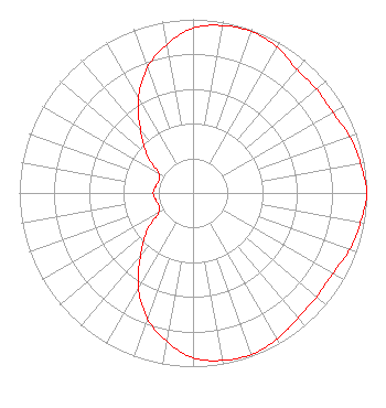 | |||||||||||||||||||
| Azimuth | Ratio | Azimuth | Ratio | Azimuth | Ratio | Azimuth | Ratio | |||||||||||||
| 0 | 0.949 | 10 | 0.979 | 20 | 0.989 | 30 | 0.969 | |||||||||||||
| 40 | 0.929 | 50 | 0.929 | 60 | 0.929 | 70 | 0.959 | |||||||||||||
| 80 | 0.979 | 90 | 1.000 | 100 | 0.979 | 110 | 0.959 | |||||||||||||
| 120 | 0.929 | 130 | 0.929 | 140 | 0.939 | 150 | 0.969 | |||||||||||||
| 160 | 0.989 | 170 | 0.979 | 180 | 0.949 | 190 | 0.869 | |||||||||||||
| 200 | 0.769 | 210 | 0.629 | 220 | 0.469 | 230 | 0.349 | |||||||||||||
| 240 | 0.229 | 250 | 0.209 | 260 | 0.219 | 270 | 0.229 | |||||||||||||
| 280 | 0.219 | 290 | 0.209 | 300 | 0.229 | 310 | 0.349 | |||||||||||||
| 320 | 0.469 | 330 | 0.629 | 340 | 0.769 | 350 | 0.869 | |||||||||||||
Structure Registration Number 1275837 Structure Type: TOWER Registered To: American Towers LLC Structure Address: Beverly Mountain Cedarville, AR County Name: Crawford County ASR Issued: 01/05/2021 Date Built: 06/01/1994 Site Elevation: 335.6 m (1101 ft.) Structure Height: 44.5 m (146 ft.) Height Overall: 48.8 m (160 ft.) Overall Height AMSL: 384.4 m (1261 ft.) FAA Determination: 09/07/2010 FAA Study #: 2010-ASW-4968-OE Paint & Light FAA Chapters: NONE 35-31-30.2 N 94-22-28.2 W (NAD 83) 35-31-29.9 N 94-22-27.4 W (Converted to NAD 27) |
38955 Hills Tech Dr. Farmington Hills, MI 48331 Phone: 248-536-0776 Limited Liability Company | Title: Manager Date: 06/25/2020 Application Certifier KTV MEDIA Ktv Media, Llc P. O. Box 23808 Little Rock, AR 72221 Applicant LARRY MORTON Ellis-wilson, Llc Little Rock, AR 72221 MANAGER | ||||||||||||||||||