
FCCInfo.com
A Service of Cavell, Mertz & Associates, Inc.
(855) FCC-INFO
|
|
KWPX-TV from 03/09/1998 KWPX-TV from 01/30/1987 |
Virtual Channel 33 |  |
|
||||||||||||||||||
|
|
Repacking Information: No changes Status: License Application Accepted: 10/25/2011 License Expires: 02/01/2023 File Number: BLCDT-20111025AIR Prefix Type: This is a License for a commercial digital TV station FCC Website Links: LMS Facility Details This Application Other KWPX-TV Applications Including Superseded Applications Mailing Address Correspondence for KWPX-TV Correspondence related to application BLCDT-20111025AIR Service Contour - Open Street Map or USGS Map (41 dBu) Service Contour - KML / Google Earth (41 dBu) Public Inspection Files Rabbit Ears Info Search for KWPX-TV Site Location: 47-30-16.3 N 121-58-10.0 W (NAD 83) Site Location: 47-30-16.9 N 121-58-05.6 W (Converted to NAD 27) ERP: 400 kW Polarization: Horizontally polarized HAAT: 716 m (2349 ft.) Electrical Beam Tilt: 1 degree R/C AGL: 82.9 m (272 ft.) R/C AMSL: 948.2 m (3111 ft.) Site Elevation: 865.3 m. (2839 ft.) Height Overall*: 94.5 m (310 ft.) (* As Filed In This Application, may differ from ASR Data, Below.) Directional Antenna - Antenna Make/Model: DIELECTRIC TFU-31ETT-R CTSP Antenna ID: 87819 Polarization: Horizontally polarized | |||||||||||||||||||||
| Antenna Data for Antenna Id: 87819 KWPX-TV DT File: BLCDT-20111025AIR DIELECTRIC - TFU-31ETT-R CTSP Service: DT Standard Pattern: Y | 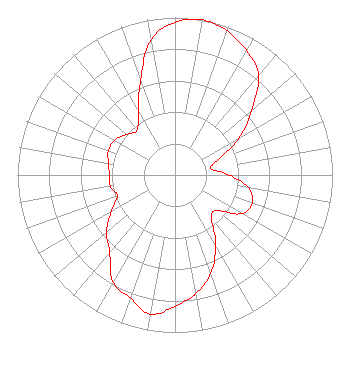 | |||||||||||||||||||||
| Azimuth | Ratio | Azimuth | Ratio | Azimuth | Ratio | Azimuth | Ratio | |||||||||||||||
| 0 | 0.970 | 10 | 1.000 | 20 | 0.973 | 30 | 0.910 | |||||||||||||||
| 40 | 0.826 | 50 | 0.635 | 60 | 0.471 | 70 | 0.298 | |||||||||||||||
| 80 | 0.228 | 90 | 0.347 | 100 | 0.473 | 110 | 0.522 | |||||||||||||||
| 120 | 0.490 | 130 | 0.348 | 140 | 0.360 | 150 | 0.517 | |||||||||||||||
| 160 | 0.665 | 170 | 0.764 | 180 | 0.834 | 190 | 0.897 | |||||||||||||||
| 200 | 0.831 | 210 | 0.787 | 220 | 0.645 | 230 | 0.569 | |||||||||||||||
| 240 | 0.467 | 250 | 0.390 | 260 | 0.416 | 270 | 0.416 | |||||||||||||||
| 280 | 0.429 | 290 | 0.450 | 300 | 0.442 | 310 | 0.400 | |||||||||||||||
| 320 | 0.373 | 330 | 0.468 | 340 | 0.639 | 350 | 0.874 | |||||||||||||||
Structure Registration Number 1056094 [ASR Heights Differ from KWPX-TV Application] Structure Type: LTOWER Registered To: American Towers LLC Structure Address: 10812 279th Ave. So. East (7500) Issaquah, WA County Name: King County ASR Issued: 04/12/2024 Date Built: 12/01/1998 Site Elevation: 865.3 m (2839 ft.) Structure Height: 69.2 m (227 ft.) Height Overall: 91.4 m (300 ft.) Overall Height AMSL: 956.7 m (3139 ft.) FAA Determination: 02/22/2021 FAA Study #: 2019-ANM-7690-OE FAA Circular #: 70/7460-1M Paint & Light FAA Chapters: 4, 8, 15 PRIOR STUDY 2019-ANM-3452-OE 47-30-16.3 N 121-58-10.0 W (NAD 83) 47-30-16.9 N 121-58-05.6 W (Converted to NAD 27) |
312 Walnut Street 28th Floor Cincinnati, OH 45202 Phone: 513-977-3000 Limited Liability Company | Date: 10/25/2011 Application Certifier ION MEDIA LICENSE COMPANY, LLC 601 Clearwater Park Road West Palm Beach, FL 33401-6233 Applicant PAUL TITCHENAL 14444 66th St. N Clearwater, FL 33764 DIRECTOR OF BROADCAST DEVELOPMENT WILLIAM L. WATSON Ion Media Networks, Inc. 601 Clearwater Park Road West Palm Beach, FL 33401-6233 | ||||||||||||||||||||
| ||||||||||||||||||||||