
FCCInfo.com
A Service of Cavell, Mertz & Associates, Inc.
(855) FCC-INFO
|
|
K24JG-D from 09/11/1987 |
|
|
||||||||||||||||
|
|
Status: License Application Accepted: 07/22/2014 License Expires: 02/01/2014 File Number: BLDTT-20140722ACZ Prefix Type: This is BLDTT FCC Website Links: LMS Facility Details This Application Other K24JG-D Applications Including Superseded Applications Mailing Address Correspondence for K24JG-D Correspondence related to application BLDTT-20140722ACZ Service Contour - Open Street Map or USGS Map (51 dBu) Service Contour - KML / Google Earth (51 dBu) Rabbit Ears Info Search for K24JG-D Site Location: 42-02-01.0 N 97-21-55.0 W (NAD 83) Site Location: 42-02-01.0 N 97-21-53.8 W (Converted to NAD 27) ERP: 15 kW Electrical Beam Tilt: 1 degree R/C AGL: 83 m (272 ft.) R/C AMSL: 585.9 m (1922 ft.) Emission Mask: Simple Site Elevation: 502.9 m. (1650 ft.) Height Overall*: 92.4 m (303 ft.) (* As Filed In This Application, may differ from ASR Data, Below.) Directional Antenna - Antenna Make/Model: DIELECTRIC TLP-8B Antenna ID: 118123
| ||||||||||||||||||
| Antenna Data for Antenna Id: 118123 K24JG-D LD File: BLDTT-20140722ACZ DIELECTRIC - TLP-8B Service: LD Standard Pattern: Y Pattern and Field Values Include a 280° Clockwise Rotation | 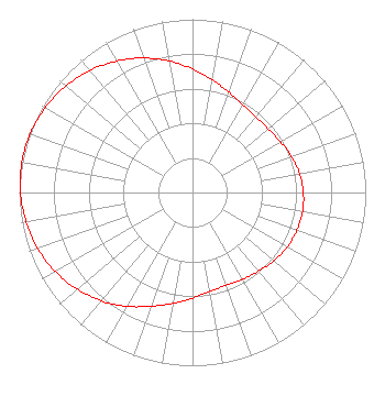 | ||||||||||||||||||
| Azimuth | Ratio | Azimuth | Ratio | Azimuth | Ratio | Azimuth | Ratio | ||||||||||||
| 0 | 0.714 | 10 | 0.661 | 20 | 0.615 | 30 | 0.583 | ||||||||||||
| 40 | 0.569 | 50 | 0.571 | 60 | 0.586 | 70 | 0.607 | ||||||||||||
| 80 | 0.627 | 90 | 0.640 | 100 | 0.645 | 110 | 0.641 | ||||||||||||
| 120 | 0.631 | 130 | 0.613 | 140 | 0.592 | 150 | 0.579 | ||||||||||||
| 160 | 0.570 | 170 | 0.579 | 180 | 0.610 | 190 | 0.650 | ||||||||||||
| 200 | 0.699 | 210 | 0.759 | 220 | 0.817 | 230 | 0.869 | ||||||||||||
| 240 | 0.914 | 250 | 0.951 | 260 | 0.975 | 270 | 0.993 | ||||||||||||
| 280 | 1.000 | 290 | 0.996 | 300 | 0.981 | 310 | 0.955 | ||||||||||||
| 320 | 0.920 | 330 | 0.876 | 340 | 0.826 | 350 | 0.771 | ||||||||||||
Structure Registration Number 1011397 Structure Type: LTOWER Registered To: Gray Media Group, Inc. Structure Address: 2.1 Km Ne Jct Hwys 35 & 275 Norfolk, NE County Name: Stanton County ASR Issued: 08/03/2021 Date Built: 01/01/1965 Site Elevation: 502.9 m (1650 ft.) Structure Height: 91.4 m (300 ft.) Height Overall: 92.4 m (303 ft.) Overall Height AMSL: 595.3 m (1953 ft.) FAA Determination: 03/02/2014 FAA Study #: NOS-31-000183 Paint & Light FAA Chapters: 1, 3, 12, 21 RED LIGHTS/PAINT 42-02-01.0 N 97-21-55.0 W (NAD 83) 42-02-01.0 N 97-21-53.8 W (Converted to NAD 27) |
4370 Peachtree Road, Ne Atlanta, GA 30319 Phone: 404-504-9828 Limited Liability Company | Date: 07/22/2014 Application Certifier KTIV TELEVISION, INC. P.o. Box 909 Quincy, IL 62306 Applicant D. SCOTT TURPIE Lohnes & Culver Llc P.o. Box 881 Silver Spring, MD 20918-0881 TECHNICAL CONSULTANT STEPHEN HARTZELL Brooks, Pierce, Et Al. | |||||||||||||||||