
FCCInfo.com
A Service of Cavell, Mertz & Associates, Inc.
(855) FCC-INFO
|
|
|
Virtual Channel 16 |  |
|
||||||||||||||||||
|
|
Repacking Information: No changes Status: License Application Accepted: 11/10/2009 License Expires: 12/01/2021 File Number: BLCDT-20091110ADL Prefix Type: This is a License for a commercial digital TV station FCC Website Links: LMS Facility Details This Application Other WTJR Applications Including Superseded Applications Mailing Address Correspondence for WTJR Correspondence related to application BLCDT-20091110ADL Service Contour - Open Street Map or USGS Map (41 dBu) Service Contour - KML / Google Earth (41 dBu) Public Inspection Files Rabbit Ears Info Search for WTJR Site Location: 39-58-19.3 N 91-19-40.4 W (NAD 83) Site Location: 39-58-19.1 N 91-19-39.9 W (Converted to NAD 27) ERP: 1000 kW Polarization: Horizontally polarized HAAT: 308 m (1010 ft.) Electrical Beam Tilt: 0.5 degrees R/C AGL: 268 m (879 ft.) R/C AMSL: 495.7 m (1626 ft.) Site Elevation: 227.7 m. (747 ft.) Height Overall*: 273.1 m (896 ft.) (* As Filed In This Application, may differ from ASR Data, Below.) Directional Antenna - Antenna Make/Model: Electronics Research Inc. ATW25H3-HTP1-32S Antenna ID: 102705 Polarization: Horizontally polarized | |||||||||||||||||||||
| Antenna Data for Antenna Id: 102705 WTJR DT File: BLCDT-20091110ADL Electronics Research Inc. - ATW25H3-HTP1-32S Service: DT Standard Pattern: Y | 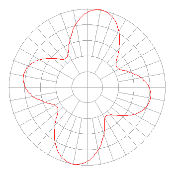 | |||||||||||||||||||||
| Azimuth | Ratio | Azimuth | Ratio | Azimuth | Ratio | Azimuth | Ratio | |||||||||||||||
| 0 | 0.951 | 10 | 1.000 | 20 | 0.951 | 30 | 0.816 | |||||||||||||||
| 40 | 0.636 | 50 | 0.485 | 60 | 0.464 | 70 | 0.568 | |||||||||||||||
| 80 | 0.697 | 90 | 0.790 | 100 | 0.823 | 110 | 0.790 | |||||||||||||||
| 120 | 0.697 | 130 | 0.568 | 140 | 0.464 | 150 | 0.458 | |||||||||||||||
| 160 | 0.636 | 170 | 0.816 | 180 | 0.951 | 190 | 1.000 | |||||||||||||||
| 200 | 0.951 | 210 | 0.816 | 220 | 0.636 | 230 | 0.485 | |||||||||||||||
| 240 | 0.464 | 250 | 0.568 | 260 | 0.697 | 270 | 0.790 | |||||||||||||||
| 280 | 0.823 | 290 | 0.790 | 300 | 0.697 | 310 | 0.568 | |||||||||||||||
| 320 | 0.464 | 330 | 0.485 | 340 | 0.636 | 350 | 0.816 | |||||||||||||||
Structure Registration Number 1009806 Structure Type: GTOWER Registered To: American Towers LLC Structure Address: 3420 N. Cannonball (quincy-il#050994) Quincy, IL County Name: Adams County ASR Issued: 02/12/2015 Date Built: 10/07/2002 Site Elevation: 227.7 m (747 ft.) Structure Height: 259 m (850 ft.) Height Overall: 273.1 m (896 ft.) Overall Height AMSL: 500.8 m (1643 ft.) FAA Determination: 02/11/2015 FAA Study #: 2015-AGL-1844-OE FAA Circular #: 70/7460-1K Paint & Light FAA Chapters: 4, 9, 12 OM&L to remain the same as prior study = A HIGH-DUAL SYSTEM 39-58-19.3 N 91-19-40.4 W (NAD 83) 39-58-19.1 N 91-19-39.9 W (Converted to NAD 27) |
6922 142nd Ave Largo, FL 33771 Phone: 727-535-5622 Not-for-Profit | Date: 11/10/2009 Application Certifier CHRISTIAN TELEVISION NETWORK, INC. 6922 142nd Ave. N. Largo, FL 33771 Applicant CHRIS L. MAVROS 6922 142nd Ave N. Largo, FL 33771 DIRECTOR OF ENGINEERING JOSEPH C. CHAUTIN, III, ESQ. Hardy, Carey, Chautin & Balkin, Llp | ||||||||||||||||||||
| ||||||||||||||||||||||