
FCCInfo.com
A Service of Cavell, Mertz & Associates, Inc.
(855) FCC-INFO
|
|
|
|
|
||||||||||||||||
|
|
Status: License Application Accepted: 08/17/2009 License Expires: 06/01/2022 File Number: BLDTL-20090817AAH Prefix Type: This is BLDTL FCC Website Links: LMS Facility Details This Application Other K24HG-D Applications Including Superseded Applications Mailing Address Correspondence for K24HG-D Correspondence related to application BLDTL-20090817AAH Service Contour - Open Street Map or USGS Map (51 dBu) Service Contour - KML / Google Earth (51 dBu) Rabbit Ears Info Search for K24HG-D Site Location: 40-38-04.0 N 99-41-52.0 W (NAD 83) Site Location: 40-38-04.0 N 99-41-50.6 W (Converted to NAD 27) ERP: 1.1 kW R/C AGL: 90 m (295 ft.) R/C AMSL: 878 m (2881 ft.) Emission Mask: Simple Site Elevation: 788 m. (2585 ft.) Height Overall*: 92 m (302 ft.) (* As Filed In This Application, may differ from ASR Data, Below.) Directional Antenna - Antenna Make/Model: ANIXTER MARK 2 X P-6A120GN-S Antenna ID: 72254 | ||||||||||||||||||
| Antenna Data for Antenna Id: 72254 K24HG-D LD File: BLDTL-20090817AAH ANIXTER MARK - 2 X P-6A120GN-S Service: LD Standard Pattern: Y Pattern and Field Values Include a 240° Clockwise Rotation | 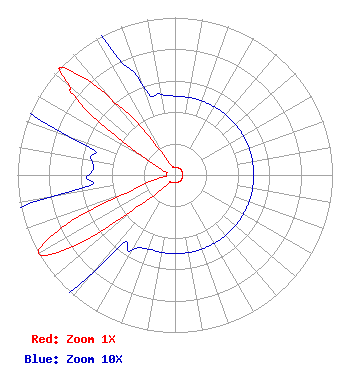 | ||||||||||||||||||
| Azimuth | Ratio | Azimuth | Ratio | Azimuth | Ratio | Azimuth | Ratio | ||||||||||||
| 0 | 0.050 | 10 | 0.050 | 20 | 0.050 | 30 | 0.050 | ||||||||||||
| 40 | 0.050 | 50 | 0.050 | 60 | 0.050 | 70 | 0.050 | ||||||||||||
| 80 | 0.050 | 90 | 0.050 | 100 | 0.050 | 110 | 0.050 | ||||||||||||
| 120 | 0.050 | 130 | 0.050 | 140 | 0.050 | 150 | 0.050 | ||||||||||||
| 160 | 0.050 | 170 | 0.050 | 180 | 0.050 | 190 | 0.050 | ||||||||||||
| 200 | 0.050 | 210 | 0.055 | 220 | 0.079 | 230 | 0.316 | ||||||||||||
| 235 | 0.794 | 240 | 1.000 | 245 | 0.794 | 250 | 0.316 | ||||||||||||
| 260 | 0.079 | 270 | 0.055 | 280 | 0.054 | 290 | 0.072 | ||||||||||||
| 300 | 0.245 | 308 | 0.794 | 310 | 0.876 | 313 | 1.000 | ||||||||||||
| 318 | 0.794 | 320 | 0.603 | 330 | 0.150 | 340 | 0.062 | ||||||||||||
| 350 | 0.052 | ||||||||||||||||||
Structure Registration Number 1041787 Structure Type: TOWER Registered To: Gray Media Group, Inc. Structure Address: 4.5 Mi N & 2 Mi E Smithfield, NE County Name: Gosper County ASR Issued: 09/09/2020 Date Built: 01/01/1984 Site Elevation: 788 m (2585 ft.) Structure Height: 92 m (302 ft.) Height Overall: 92 m (302 ft.) Overall Height AMSL: 880 m (2887 ft.) Paint & Light FAA Chapters: 1, 3, 12, 21 40-38-04.0 N 99-41-52.0 W (NAD 83) 40-38-04.0 N 99-41-50.6 W (Converted to NAD 27) |
840 North 40th Street Lincoln, NE 68503 Phone: 402-467-4321 Applicant | Date: 08/17/2009 Application Certifier GRAY TELEVISION LICENSEE, LLC P.o. Box 30350 Lincoln, NE 68503 Applicant BRENT HAUN P.o. Box 30350 Lincoln, NE 68503 CHIEF ENGINEER JOAN STEWART, ESQ. Wiley Rein Llp | |||||||||||||||||