
FCCInfo.com
A Service of Cavell, Mertz & Associates, Inc.
(855) FCC-INFO
|
|
KMYU from 09/11/1989 |
Virtual Channel 12 |  |
|
||||||||||||||||||||||||||||||||||||
|
|
Repacking Information: No changes Status: License Application Accepted: 10/31/2002 License Expires: 10/01/2014 File Number: BLCDT-20021031ABG Prefix Type: This is a License for a commercial digital TV station FCC Website Links: LMS Facility Details This Application Other KMYU Applications Including Superseded Applications Mailing Address Correspondence for KMYU Correspondence related to application BLCDT-20021031ABG Service Contour - Open Street Map or USGS Map (36 dBu) Service Contour - KML / Google Earth (36 dBu) Public Inspection Files Rabbit Ears Info Search for KMYU Site Location: 37-03-48.0 N 113-34-26.0 W (NAD 83) Site Location: 37-03-48.1 N 113-34-23.2 W (Converted to NAD 27) ERP: 3.2 kW Polarization: Horizontally polarized HAAT: 43 m (141 ft.) R/C AGL: 7 m (23 ft.) R/C AMSL: 965 m (3166 ft.) Site Elevation: 958 m. (3143 ft.) Height Overall*: 29 m (95 ft.) (* As Filed In This Application, may differ from ASR Data, Below.) Directional Antenna - Antenna Make/Model: DIELECTRIC THP-C1-4-1R Antenna ID: 44874 Polarization: Horizontally polarized
| |||||||||||||||||||||||||||||||||||||||
| Antenna Data for Antenna Id: 44874 KMYU DT File: BLCDT-20021031ABG DIELECTRIC - THP-C1-4-1R Service: DT Standard Pattern: Y | 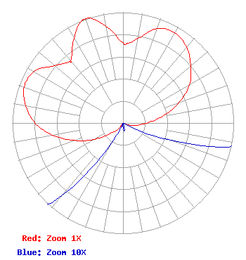 | |||||||||||||||||||||||||||||||||||||||
| Azimuth | Ratio | Azimuth | Ratio | Azimuth | Ratio | Azimuth | Ratio | |||||||||||||||||||||||||||||||||
| 0 | 0.726 | 3 | 0.719 | 10 | 0.775 | 20 | 0.908 | |||||||||||||||||||||||||||||||||
| 30 | 0.939 | 40 | 0.893 | 50 | 0.800 | 60 | 0.694 | |||||||||||||||||||||||||||||||||
| 70 | 0.539 | 80 | 0.371 | 90 | 0.216 | 100 | 0.124 | |||||||||||||||||||||||||||||||||
| 110 | 0.046 | 120 | 0.001 | 130 | 0.001 | 140 | 0.001 | |||||||||||||||||||||||||||||||||
| 150 | 0.001 | 160 | 0.001 | 170 | 0.007 | 180 | 0.004 | |||||||||||||||||||||||||||||||||
| 190 | 0.001 | 200 | 0.001 | 210 | 0.021 | 220 | 0.086 | |||||||||||||||||||||||||||||||||
| 230 | 0.145 | 240 | 0.295 | 250 | 0.462 | 260 | 0.645 | |||||||||||||||||||||||||||||||||
| 270 | 0.794 | 280 | 0.893 | 290 | 0.950 | 300 | 0.929 | |||||||||||||||||||||||||||||||||
| 310 | 0.807 | 319 | 0.734 | 320 | 0.736 | 330 | 0.883 | |||||||||||||||||||||||||||||||||
| 338 | 0.994 | 340 | 1.000 | 342 | 0.997 | 350 | 0.886 | |||||||||||||||||||||||||||||||||
Structure Registration Number 1053312 [ASR Heights Differ from KMYU Application] Structure Type: LTOWER Registered To: American Towers LLC Structure Address: Webb Hill - Washington County (#209530) St. George, UT County Name: Washington County ASR Issued: 03/21/2022 Date Built: 04/23/1999 Site Elevation: 951.9 m (3123 ft.) Structure Height: 27.4 m (90 ft.) Height Overall: 28.9 m (95 ft.) Overall Height AMSL: 980.8 m (3218 ft.) FAA Determination: 02/18/2022 FAA Study #: 2022-ANM-1248-OE Paint & Light FAA Chapters: NONE PRIOR STUDY 2021-ANM-4683-OE 37-03-49.3 N 113-34-25.7 W (NAD 83) 37-03-49.4 N 113-34-22.9 W (Converted to NAD 27) |
1200 Seventeenth Street, Nw Washington, Dc, MD 21030 Phone: 212-663-8195 Limited Liability Company | Date: 10/31/2002 Application Certifier KUTV HOLDINGS INC. Suite 725 2000 K Street Nw Washington, DC 20006-1809 Applicant EDWIN L. NASS Suite 725 2000 K Street, Nw Washington, DC 20006-1809 SPECTRUM MANAGER | ||||||||||||||||||||||||||||||||||||||